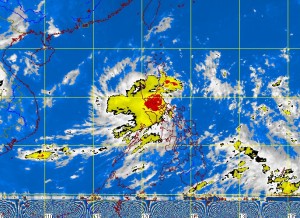
MANILA, Philippines—Hours of heavy rain spawned by a low pressure area off Batangas triggered floods in Southern and Central Luzon, including Metro Manila, prompting the suspension of classes in many places.
The rain, which began pouring after midnight Monday, was so widespread and continuous that it triggered floods in many parts of the capital, submerging cars and stranding motorists and commuters, and prompting local chief executives and school officials to suspend classes.
“Its circulation is wide, that’s why it affected a large area. It has a wide band of clouds. It’s a mini storm without the winds,’’ forecaster Jori Loiz said in an interview before noon Tuesday.
The Philippine Atmospheric, Geophysical and Astronomical Services Administration recorded light to moderate to heavy to intense rainfall in Tanay, Rizal; Sangley, Cavite, and Science Garden in Quezon City, becoming torrential at the Port Area in Manila.
Some 43.4 millimeters of rainfall (torrential) was recorded at the Port Area, 22.9 mm in Science Garden, and 22.4 mm in Sangley (both intense), all at around 3 a.m. Tuesday.
“It will continue to bring moderate to heavy rain over Central and Southern Luzon, including Metro Manila, and even Western Visayas, but the rain will be isolated. By Thursday, we will have improving weather,’’ Loiz said.
The low pressure area, located 50 kilometers west southwest of Manila at 8 a.m., could develop into a depression while swirling away from the archipelago toward the West Philippine Sea, he said.
