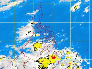
MTSAT ENHANCED IR Satellite Image
MANILA, Philippines—Except for some occasional rains, expect the weather throughout Luzon to improve in the coming days.
Tropical storm “Carina” swirled through the Philippine area of responsibility (PAR) for a few hours Wednesday night before exiting and dissipating, weather forecasters said on Thursday.
Carina (international name: Talim) entered the northwestern tip of the PAR between 6 and 7 p.m. Wednesday, and exited at around 9 p.m., dissipating over southern China, forecaster Ricky Fabregas said in an interview.
The storm, the third cyclone to enter PAR, induced moderate monsoon rains over the western section of northern Luzon, according to the Philippine Atmospheric, Geophysical and Astronomical Services Administration (Pagasa).
Even without any active storm, the southwest monsoon would spawn occasional rains over Northern and Central Luzon, becoming frequent rains over their western section, Pagasa said.
Pagasa is keeping the alert for flash floods and landslides in these areas.
“We will have improving weather in Northern and Central Luzon in the next five days,” Fabregas said by phone. “Metro Manila will have good weather toward weekend.’’
The weather outlook for Visayas and Mindanao would depend on the development of the low pressure area (LPA) east of Visayas, he said.
The LPA, spotted 480 kilometers east of eastern Visayas before dawn Thursday, would likely dissipate because of its “disorganized” clouds, he said.
According to Pagasa, Eastern Visayas and Mindanao will experience cloudy skies with scattered rain showers and thunderstorms.