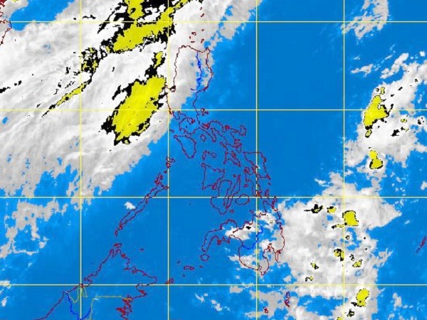
MTSAT ENHANCED IR Satellite Image for 3:32 P.M., 20 June 2012
MANILA, Philippines—Tropical storm “Talim” induced monsoon rains over Luzon, but was forecast to skirt the Philippine area of responsibility (PAR) and strike Taiwan instead.
Changing direction from east northeast to northeast over the West Philippine Sea, the storm would not swirl into the PAR after all, but would induce monsoon rain over northern Luzon, weather forecasters said on Wednesday.
“It has a small chance of entering PAR. If at all, it would only graze the corner of PAR,’’ forecaster Aldczar Aurelio of the Philippine Atmospheric, Geophysical and Astronomical Services Administration (Pagasa) said in an interview.
The bigger possibility was that the storm would swirl between Taiwan and China Wednesday night above the PAR, but would induce light to moderate monsoon rains over northern Luzon, he said.
The rain would be “concentrated” in the western section of northern Luzon, he said.
“Residents there should still watch out for flash floods and landslides given that the mountains there are denuded,” Aurelio said, adding that Taiwan should brace for “moderate to heavy rain” Wednesday night and onwards. “Taiwan would feel its impact.”
By Wednesday morning, the storm was swirling northeast at 22 kph over the sea some 450 kilometers west northwest of Basco, Batanes, in the northern tip of the archipelago.
Packing maximum winds of 85 kilometers per hour and gusting up to 100 kph, it induced light to moderate rain over the western sections of Central and Northern Luzon Wednesday.
The seas off the western sections of Luzon turned rough to very rough because of the storm and southwest monsoon.
“It did not intensify into a typhoon over sea because its band of clouds had been diminished by the southwest monsoon,” Aurelio said.
The weather bureau was also monitoring a low pressure area 2,000 kilometers east of Visayas but still outside the PAR.