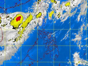
A rare tropical depression that has formed over the West Philippine Sea (South China Sea) has intensified into a tropical storm and could bring rains to northern and Central Luzon beginning Wednesday, the Philippine Atmospheric Geophysical and Astronomical Services Administration (Pagasa) said.
Pagasa said it was monitoring the new storm (international name: Talim), which formed over southern China, as it was expected to enter the Philippine area of responsibility (PAR) Wednesday.
As of 5 p.m. Monday, Pagasa said Talim was still outside the PAR.
Pagasa said the storm was spotted 800 kilometers west of extreme northern Luzon packing maximum sustained winds of 75 kilometers per hour near the center and gustiness of up to 90 kph. But the storm was moving slowly.
Samuel Duran, a Pagasa forecaster, said the weather disturbance would be named Carina once it entered the country. “It is expected to pass between the northern tip of Luzon and Taiwan,” he said.
Duran said a full blown tropical depression coming from the West Philippine Sea was uncommon. Usually, weather disturbances in that region were limited to low pressure areas.
Talim is expected to strengthen as it moves westerly, Duran said.
But models showed the storm would not make landfall in the Philippines, he said. It could affect the weather though as it would enhance the southwest monsoon over Central and northern Luzon, he added.
With Talim in the west and Typhoon Butchoy in the west, the Philippines was sandwiched between two weather disturbances on Monday.
