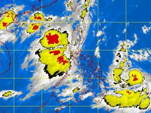
MANILA, Philippines — Tropical storm “Butchoy” (international name Guchol) has slowed down and maintained its strength as it moved west-northwest at 15 kilometers per hour, the state weather bureau said Friday.
As of 4 a.m., Butchoy was seen 620 kilometers east-southeast of Guiaian Eastern Samar with maximum sustained winds of 100 kph near the center and gustiness of up to 130 kph, the Philippines Atmospheric Geophysical and Astronomical Services Administration said.
Pagasa forecasters said that they were closely monitoring Butchoy, even if forecast models said that it wouldn’t make landfall.
It also advised to wait for the next advisory, on whether Butchoy has intensified into a typhoon as reported by the Joint Typhoon Warning Center in Hawaii.
The JTWC data early Friday said that Butchoy has intensified from tropical storm to typhoon, with maximum sustained winds of up to 80 knots and gusts of up to 100 knots.
Meanwhile, rains are seen in parts of the country also due to a prevailing southwest monsoon in Luzon.
Luzon will experience occasional rains becoming frequent over the western section which may trigger flashfloods and landslides. The rest of the country will have cloudy skies with scattered rainshowers or thunderstorms, Pagasa said.
Moderate to strong winds blowing from the southwest will prevail over the whole archipelago with moderate to rough seas.
Major dams in Luzon are also in safe levels as of 6a.m., and has not opened their gates as of 6 a.m., Pagasa said.
It also advised fishing boats and other small seacraft not to venture out into the sea while larger vessels are alerted ahainst big waves.
