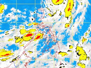
MANILA, Philippines – A new active low pressure area was seen as typhoon “Ambo” moved away from the country, state weather forecasters said Monday.
At 4a.m., the low pressure area was seen 870 kilometers east of Southern Mindanao, the Philippine Atmospheric Geophysical Astronomical Services Administration (Pagasa) said.
Pagasa said once the low pressure area that already entered the Philippine area of responsibility intensifies, it will be called “Butchoy”.
Meanwhile, Ambo no longer posed any threat in the country even as it moved with maximum sustained winds of 140 kilometers per hour near the center and gustiness of up to 170 kph. It was seen 380 km east of Basco, Batanes and was forecast to move north northeast at 15 kph. “Ambo” was expected to be at 640 km northeast of Basco, Batanes by Tuesday morning, and 980 km northeast of Basco, Batanes by Wednesday morning.
Fishing boats and other small seacrafts were advised not to venture out into the sea while larger sea vessels are alerted against big waves due to strong to gale force wind expected to affect the seaboards of Luzon and the western seaboard of Visayas, Pagasa said.
The western section of Northern and Central Luzon will experience cloudy skies with scattered to widespread rains and thunderstorms which may trigger flashfloods and landslides while the rest of Luzon and Western Visayas will have monsoon rains. The rest of Visayas and Mindanao will have partly cloudy to cloudy skies with isolated rainshowers or thunderstorms, it also said.
Moderate to strong winds blowing from the northwest to west will prevail over Extreme Northern Luzon and coming from the southwest over the rest of the country. The coastal waters throughout the archipelago will be moderate to rough, Pagasa added.
