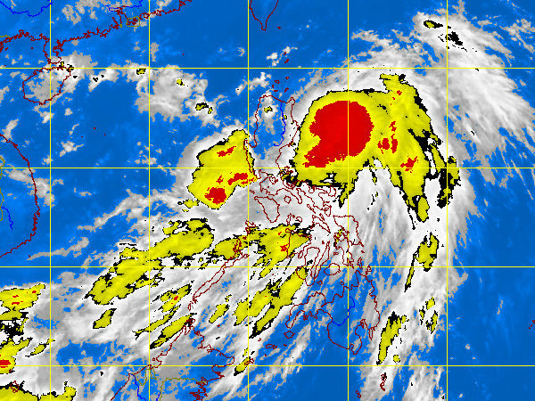
MTSAT ENHANCED IR Satellite Image for 11:32 a.m., 02 June 2012. pagasa.dost.gov.ph
MANILA, Philippines — Tropical storm “Ambo” slightly intensified over the Philippine Sea as it swirled toward extreme northern Luzon, further enhancing monsoon rains over Luzon and Visayas, forecasters said before noon Saturday.
Apart from Aurora and Isabela, the Philippine Atmospheric Geophysical Astronomical Services Administration (Pagasa) raised Storm Signal No. 1 over Cagayan, including Babuyan and Batanes Group of Islands.
While it intensified, packing maximum winds of 85 kilometers per hour and gusting up to 100 kph, Ambo will not directly affect the archipelago because its diameter grew smaller to 400 kilometers, forecaster Aldczar Aurelio said.
The storm (international codename: Mawar), however, will also enhance monsoon rains over Luzon and Visayas between now and its exit early Tuesday morning.
“Expect moderate to heavy rainfall,” Aurelio told reporters in a briefing, pointing out that the storm will generate 15 millimeters to 25 millimeters of rainfall per hour, considered heavy.
The bureau advised residents of areas under Signal No. 1 to watch out for flashfloods and landslides.
By 10 a.m. Saturday, the storm was 200 km east-northeast of Casiguran, Aurora, and was forecast to be 240 km northeast of Aparri, Cagayan Sunday morning.
Since it has slowed down to 13 kph as it swirled north northwest close to extreme northern Luzon, the storm was expected to pick up more moisture over the sea, and there was a “ig chance” it could intensify into a typhoon before it exits toward Japan, Aurelio said.
And if it does, its direct effect on the archipelago will depend on its diameter, he said.