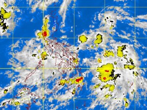
A low pressure area off the Bicol region has enhanced monsoon rains over southern Luzon and the Visayas, and could intensify into a tropical depression toward the weekend, weather forecasters said Wednesday.
If it does intensify, it will be the first tropical cyclone to cross the archipelago this year and would be named “Ambo,” according to weather forecaster Nikos Peñaranda.
While still too far to affect the archipelago, the low pressure area has intensified winds from the southwest or the southwest monsoon, bringing more rain over southern Luzon, including Palawan and the Visayas, Peñaranda said.
Within the next two days, the isolated thunderstorms and rainshowers over northern and Central Luzon would become scattered over southern Luzon and the Visayas, said Peñaranda of the Philippine Atmospheric Geophysical and Astronomical Services Administration (Pagasa).
“It will be more rainy in southern Luzon and the Visayas,” he said by phone.
The low pressure area was spotted in the Philippine Sea, 520 kilometers east of Catarman, Northern Samar, at around 2 a.m. on Wednesday.
It was moving northwestward and was heading toward extreme northern Luzon, he said.
“Based on our models, it could directly affect northern Luzon or it could veer off before reaching northern Luzon,” he said.
“If it develops, it will further enhance the southwest monsoon.” TJ Burgonio
Originally posted: 5:37 pm | Wednesday, May 30th, 2012
