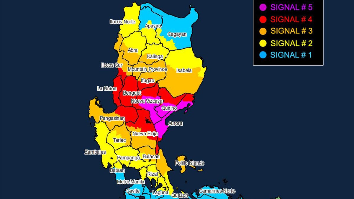
Image from the Philippine Atmospheric, Geophysical, and Astronomical Services Administration
MANILA, Philippines — Parts of Aurora, Quirino, and Nueva Vizcaya were placed under Tropical Cyclone Wind Signal (TCWS) No. 5 as Super Typhoon Pepito (international name: Man-yi) made its second landfall on Sunday afternoon, the Philippine Atmospheric, Geophysical, and Astronomical Services Administration (Pagasa) said.
According to Pagasa, Pepito was last spotted in the vicinity of Nagtipunan, Quirino after making landfall in the vicinity of Dipaculao, Aurora at 3:20 p.m.
READ: Pepito makes second landfall in Aurora
In a 5 p.m. cyclone bulletin, the state weather bureau said typhoon-force winds are expected to hit the following areas under TCWS No. 5:
- Central portion of Aurora (Dipaculao, Baler, Dinalungan, Maria Aurora, Casiguran, San Luis)
- Southern portion of Quirino (Nagtipunan)
- Southern portion of Nueva Vizcaya (Alfonso Castañeda, Dupax del Norte, Dupax del Sur, Kasibu, Aritao, Bambang)
Pagasa said winds greater than 185 kilometers per hour (kph) may be expected in areas under TCWS No. 5 within the next 12 hours, posing an extreme threat to life and property.
The state weather bureau raised TCWS No. 4 over the following areas:
- The rest of Aurora
- The rest of Nueva Vizcaya
- The rest of Quirino
- Southern portion of Ifugao (Kiangan, Lamut, Tinoc, Asipulo, Lagawe), Benguet
- Southern portion of Ilocos Sur (Alilem, Sugpon, Suyo, Santa Cruz, Tagudin)
- La Union Eastern portion of Pangasinan (Sison, Tayug, Binalonan, San Manuel, Asingan, San Quintin, Santa Maria, Natividad, San Nicolas, Balungao, Pozorrubio, Laoac, San Jacinto, San Fabian, Manaoag, City of Urdaneta, Rosales, Umingan, Mangaldan, Mapandan, Villasis, Santo Tomas)
- Northern portion of Nueva Ecija (Gabaldon, Laur, Bongabon, Pantabangan, Rizal, General Mamerto Natividad, Lupao, San Jose City, Llanera, Carranglan, Science City of Muñoz, Talugtug, Cuyapo)
These areas may experience wind speeds stronger than 118 kph up to 184 kph in the next 12 hours, according to Pagasa.
The state weather bureau also warned of significant to severe threat to life and property in areas under TCWS No. 4.
Meanwhile, the following areas were placed under TCWS No. 3, where storm-force winds ranging from 89 to 117 kph within 18 hours:
- Southern portion of Isabela (San Agustin, Jones, Echague, San Guillermo, Angadanan, Alicia, San Mateo, Ramon, San Isidro, City of Santiago, Cordon, Dinapigue, Roxas, Aurora, Cabatuan, City of Cauayan, Luna, San Mariano, Benito Soliven, Naguilian, Reina Mercedes, San Manuel, Burgos)
- The rest of Ifugao
- Mountain Province
- Southern portion of Kalinga (Pasil, Tanudan, Lubuagan, Tinglayan)
- Southern portion of Abra (Tubo, Luba, Pilar, Villaviciosa, San Isidro, Pidigan, Langiden, San Quintin, Bangued, Manabo, Boliney, Peñarrubia, Bucloc, Sallapadan, Bucay)
- The rest of Ilocos Sur
- The rest of Pangasinan
- The northern and eastern portions of Tarlac (Paniqui, La Paz, Moncada, City of Tarlac, Gerona, Pura, San Clemente, Santa Ignacia, Victoria, Camiling, Concepcion, Ramos, San Manuel, Anao)
- The rest of Nueva Ecija
- Northern portion of Bulacan (Doña Remedios Trinidad, San Miguel)
- Northern portion of Quezon (Infanta, General Nakar) including Polillo Islands
Moderate to significant threat to life and property may be experienced in areas under TCWS No. 3, the state weather bureau said.
Meanwhile, TCWS No. 2 was hoisted over the following areas:
- The rest of Isabela
- Southwestern portion of mainland Cagayan (Enrile, Tuao, Solana, Tuguegarao City, Piat, Rizal)
- The rest of Isabela Southwestern portion of mainland Cagayan (Enrile, Tuao, Solana, Tuguegarao City, Piat, Rizal)
- The rest of Kalinga
- Southern portion of Apayao (Conner, Kabugao)
- The rest of Abra
- Ilocos Norte
- Zambales
- The rest of Tarlac
- Northern portion of Bataan (Orani, Abucay, Hermosa, Samal, Dinalupihan)
- Pampanga
- The rest of Bulacan
- Metro Manila
- Rizal
- Northeastern portion of Laguna (Santa Cruz, Pila, Mabitac, Paete, Pagsanjan, Pangil, Santa Maria, Siniloan, Cavinti, Kalayaan, Lumban, Pakil, Famy)
- Central portion of Quezon (Sampaloc, Mauban, Perez, Real)
Pagasa said gale-force winds ranging from 62 to 88 kph may be expected in the next 24 hours in areas under TCWS No. 2. It also cautioned that these areas may see minor to moderate threat to life and property due to effects of the super typhoon.
TCWS No. 1 was raised over the areas listed below:
- The rest of mainland Cagayan
- The rest of Apayao
- The rest of Bataan
- Cavite
- The rest of Apayao The rest of Bataan, Cavite
- The rest of Laguna
- Batangas
- The rest of Quezon
- Northern portion of Occidental Mindoro (Abra de Ilog, Paluan) including Lubang Islands
- Northern portion of Oriental Mindoro (Puerto Galera, San Teodoro, Naujan, Baco, City of Calapan)
- Marinduque
- Camarines Norte
- Northern portion of Camarines Sur (Libmanan, Tinambac, Siruma, Cabusao, Canaman, Magarao, Calabanga, Bombon, Sipocot, Ragay, Del Gallego, Lupi, Lagonoy, Goa, Garchitorena, Pasacao, Pamplona, Camaligan, Gainza)
Intermittent rains or winds of 39 to 61 kph may be expected in these areas within the next 36 hours, according to Pagasa.
Pagasa also reminded residents in areas identified as highly or very highly susceptible to hazards to comply with evacuation orders and other directives from local authorities.
As of the latest bulletin, Pepito was packing maximum sustained winds of 185 kph near its center and a gustiness of up to 305 kph. It was moving northwestward at 25 kph.
READ: Super Typhoon Pepito prompts more evacuations in Aurora


