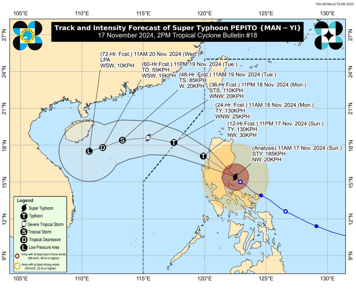
(Track from Pagasa)
MANILA, Philippines — Signal No. 5 remains hoisted over two areas as Super Typhoon Pepito (international name: Man-yi) is expected to slightly ease up into a typhoon before making a second landfall in the vicinity of Aurora on Sunday afternoon.
“Pepito is forecast to slightly weaken as a typhoon prior to its second landfall. Significant weakening will occur during the passage of this tropical cyclone over mainland Luzon today,” Philippine Atmospheric, Geophysical and Astronomical Services Administration 2 p.m. cyclone update said.
It added that Pepito will likely exit the Luzon landmass by Sunday night and exit the country’s boundary by Monday morning or noon.
So far, the super typhoon has kept its strength, moving 20 kilometers per hour (kph).
It was last seen over the coastal waters of Baler, Aurora, carrying maximum sustained winds of 185 kph and gusts of up to 230 kph.
As Pepito traverses the Philippine Sea, Pagasa’s update showed that two areas under Signal No. 5 — the southern portion of Quirino (Nagtipunan) and the southern portion of Nueva Vizcaya (Alfonso Castañeda).
(Image from Pagasa)
Meanwhile, below are other areas with wind signals:
Tropical Cyclone Wind Signal (TCWS) No. 4
- The rest of Aurora
- The rest of Nueva Vizcaya
- The rest of Quirino
- The southern portion of Ifugao (Kiangan, Lamut, Tinoc, Asipulo, Lagawe)
- Benguet
- The southern portion of Ilocos Sur (Alilem, Sugpon, Suyo, Santa Cruz, Tagudin)
- La Union
- The eastern portion of Pangasinan (Sison, Tayug, Binalonan, San Manuel, Asingan, San Quintin, Santa Maria, Natividad, San Nicolas, Balungao, Pozorrubio, Laoac, San Jacinto, San Fabian, Manaoag, City of Urdaneta, Rosales, Umingan, Mangaldan, Mapandan, Villasis, Santo Tomas)
- The northern portion of Nueva Ecija (Gabaldon, Laur, Bongabon, Pantabangan, Rizal, General Mamerto Natividad, Lupao, San Jose City, Llanera, Carranglan, Science City of Muñoz, Talugtug, Cuyapo)
- The northern and eastern portion of Polillo Islands (Panukulan, Burdeos, Patnanungan, and Jomalig)
TCWS No. 3
- The southern portion of Isabela (San Agustin, Jones, Echague, San Guillermo, Angadanan, Alicia, San Mateo, Ramon, San Isidro, City of Santiago, Cordon, Dinapigue, Roxas, San Manuel, Aurora, Cabatuan, City of Cauayan, Luna)
- The rest of Ifugao, Mountain Province
- The southern portion of Abra (Tubo, Luba, Pilar, Villaviciosa, San Isidro, Pidigan, Langiden, San Quintin, Bangued, Manabo)
- The rest of Ilocos Sur
- The rest of Pangasinan
- The northern and eastern portions of Tarlac (Paniqui, La Paz, Moncada, City of Tarlac, Gerona, Pura, San Clemente, Santa Ignacia, Victoria, Camiling, Concepcion, Ramos, San Manuel, Anao)
- The rest of Nueva Ecija, the northern portion of Bulacan (Doña Remedios Trinidad, San Miguel), The northern portion of Quezon (Infanta, General Nakar) including the rest of Polillo Islands
TCWS No. 2
- The rest of Isabela
- The southwestern portion of mainland Cagayan (Enrile, Tuao, Solana, Tuguegarao City, Piat, Rizal)
- Kalinga
- The southern portion of Apayao (Conner, Kabugao)
- The rest of Abra
- Ilocos Norte
- Zambales
- Bataan
- Pampanga
- The rest of Bulacan
- Metro Manila
- Rizal
- Cavite
- Laguna
- The central and eastern portions of Quezon (Pitogo, Buenavista, Lucena City, Calauag, Pagbilao, Tiaong, Lopez, Guinayangan, Unisan, General Luna, Plaridel, Quezon, San Antonio, Alabat, Candelaria, Lucban, Sampaloc, Padre Burgos, Sariaya, City of Tayabas, Macalelon, Mauban, Dolores, Perez, Agdangan, Gumaca, Atimonan, Real, Tagkawayan)
- Camarines Norte
- The northwestern portion of Camarines Sur (Del Gallego, Ragay, Lupi, Sipocot)
TCWS No. 1
- The rest of mainland Cagayan
- The rest of Apayao
- Batangas
- The northern portion of Occidental Mindoro (Abra de Ilog, Paluan) including Lubang Islands
- The northern portion of Oriental Mindoro (Puerto Galera, San Teodoro, Naujan, Baco, Victoria, Socorro, Pinamalayan, Gloria, Pola, City of Calapan)
- The northwestern portion of Romblon (Banton, Corcuera, Concepcion)
- Marinduque
- The rest of Quezon, the rest of Camarines Sur, Catanduanes, Albay, the northern portion of Sorsogon (Donsol, Pilar, Castilla, City of Sorsogon, Prieto Diaz)
- Burias Island
Tropical Cyclone Warning System Signals (Illustration from Ed Lustan)