Pepito to make landfall in Catanduanes within next few hours

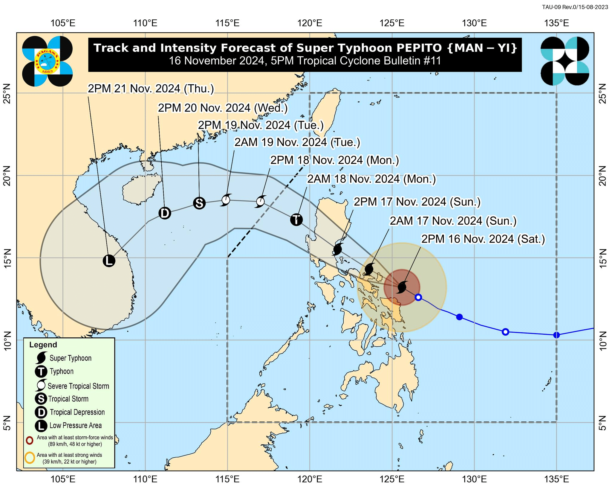
Track and intensity forecast of Super Typhoon Pepito (international name: Man-yi) as of 5 p.m., Saturday, November 16, 2024 Image by Pagasa / Facebook
MANILA, Philippines — Super Typhoon Pepito (international name: Man-yi) is set to make landfall between 8 p.m. to 11 p.m. on Saturday in Catanduanes, the Philippine Atmospheric, Geophysical and Astronomical Services (Pagasa).
READ: LIVE UPDATES: Typhoon Pepito
In a 5 p.m. briefing, Pagasa weather specialist Loriedin De La Cruz-Galicia said that there is an “increasing chance” that the eye of the super typhoon may not approach the landmass.
“There is an increasing chance that the eye of this storm will slightly shift upwards and not make direct contact with the landmass. However, the effects on Catanduanes, Camarines Sur, Albay, Sorsogon, and almost the entire Bicol region will remain the same, whether it makes landfall in Catanduanes or not,” De La Cruz-Galicia explained in a mix of Filipino and English.
The weather specialist also noted that Pepito is possible to make a landfall between Aurora or Quezon Province on Sunday afternoon or evening.
“It will traverse the eastern section of Bicol and eventually, by tomorrow afternoon or evening, it may make landfall between Aurora or Quezon Province. It will then continue to traverse or cross through the landmass of Central or Northern Luzon,” De La Cruz-Galicia added in a mix of Filipino and English.
Further, Pagasa said in its weather bulletin that Pepito is approaching its peak intensity, however, it added that “the intensity of PEPITO may begin to maintain or slightly decrease in the next coming hours.”
The weather agency located the center of the eye of Pepito some 120 kilometers east of Virac, Catanduanes, moving west-northwestward at 20 kilometers per hour (kph). It was still packing maximum wind speed of 195 kph and gustiness of up to 240 kph.
READ: Camarines Sur areas now under Signal No. 5 due to Pepito
Pagasa hoisted Tropical Cyclone Wind Signals (TCWS) across the country, with TCWS No. 5 being the highest over Catanduanes and the northeastern portion of Camarines Sur. This may bring extreme threat to life and property, with wind speed ranging from 185 kph or higher.
READ: LIST: Areas at high risk of storm surge due to Super Typhoon Pepito
The following areas will also experience torrential to heavy rainfall from Saturday to Monday afternoon:
Saturday to Sunday afternoon (November 17)
Intense to torrential (>200 millimeters of rainfall)
- Catanduanes
- Camarines Sur
- Albay
- Camarines Norte
Heavy to intense (100-200 mm)
- Quezon
- Northern Samar
- Sorsogon
Moderate to heavy (50-100 mm)
- Aurora
- Bulacan
- Rizal
- Cavite
- Laguna
- Batangas
- Marinduque
- Samar
- Leyte
- Biliran
- Eastern Samar
- Masbate
Sunday afternoon (November 17) to Monday afternoon (November 18)
Intense to torrential
- Quezon
- Aurora
- Quirino
- Nueva Vizcaya
- Nueva Ecija
- Rizal
- Benguet
- Pangasinan
Heavy to intense
- La Union
- Tarlac
- Pampanga
- Bataan
- Bulacan
- Zambales
- Metro Manila
- Cavite
- Laguna
- Camarines Norte
Moderate to heavy
- Marinduque
- Camarines Sur
- Batangas
- Cagayan
- Isabela
- Ifugao
- Mountain Province
- Kalinga
- Abra
- Ilocos Sur
A storm surge warning where peak heights exceeding 3.0 is expected in the next 48 hours over low-lying or exposed coastal communities of the following areas:
- Ilocos Region (western coast)
- Isabela
- Central Luzon
- Metro Manila
- Calabarzon (Cavite, Laguna, Batangas, Rizal, Quezon)
- Marinduque
- Bicol Region
- Northern Samar
- Samar
- Eastern Samar
- Biliran
Meanwhile, a gale warning was hoisted over the eastern and southern seaboards of Southern Luzon and the eastern seaboard of Visayas.