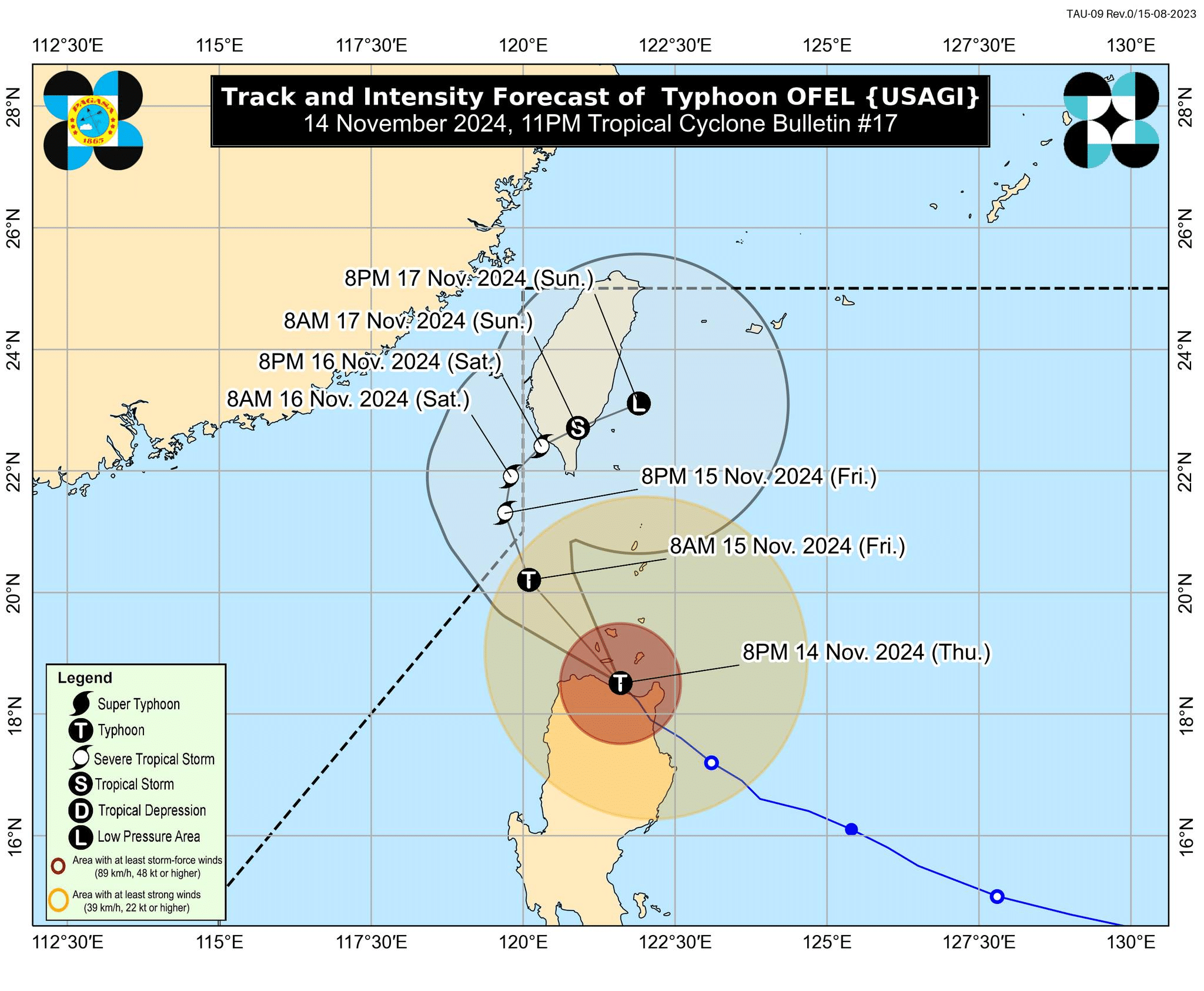
Track and intensity forecast of Typhoon Ofel (international name: Usagi) as of 11 p.m. on Thursday, November 14, 2024. (Photo by Pagasa/Facebook)
MANILA, Philippines — Typhoon Ofel (international name: Usagi) further weakened while passing through Babuyan Islands on Thursday night and is expected to re-enter the Philippine area of responsibility (PAR) on Saturday, the state weather bureau said.
In its 11 p.m. weather bulletin, the Philippine Atmospheric, Geophysical and Astronomical Services Administration (Pagasa) said that Ofel was last located over the coastal water of Calayan, Cagayan, and moving northwestward at 15 kilometers per hour (kph) with a maximum wind speed of 130 kph and gustiness of up to 200 kph.
Pagasa also noted in its bulletin that Ofel will continue to weaken throughout the forecast period “due to frictional effects of land as well as the increasingly unfavorable environment over the Luzon Strait and the sea east of Taiwan.”
READ: Ofel continues to weaken as it approaches Babuyan Islands
Furthermore, Pagasa weather specialist Daniel James Villamil said in the 11 p.m. weather briefing that the typhoon is expected to re-enter the PAR on Saturday.
“It is possible for the storm to exit PAR by Friday morning and re-enter PAR on Saturday afternoon or evening before making landfall in the Taiwan area,” Villamil said in a mix of English and Filipino.
“It is possible that later tonight or early tomorrow morning, the storm could make a second landfall or come close to any island in the Babuyan Group of Islands,” Villamil added.
READ: Pepito enters PAR, may become a typhoon
Wind signals
The following areas have been placed under Tropical Cyclone Wind Signals (TCWS) based on expected wind speeds and the potential threat to life and property:
- TCWS No. 4 (118 to 184 kph wind speed): Significant to severe threat to life and property
- Luzon:
- Northern portion of Cagayan (Santa Teresita, Ballesteros, Aparri, Camalaniugan, Buguey, Gonzaga, Santa Ana, Abulug, Pamplona, Sanchez-Mira, Claveria, Santa Praxedes, Lal-Lo, Allacapan) including Babuyan Islands
- Luzon:
- TCWS No. 3 (89 to 117 kph wind speed): Moderate to significant threat to life and property
- Luzon:
- Southern portion of Batanes (Basco, Mahatao, Ivana, Uyugan, Sabtang)
- Central and southeastern portions of mainland Cagayan (Lasam, Alcala, Amulung, Iguig, Santo Niño, Rizal, Piat, Peñablanca, Baggao, Gattaran)
- Northern and central portions of Apayao (Flora, Pudtol, Kabugao, Calanasa, Luna, Santa Marcela)
- Northern portion of Ilocos Norte (Adams, Dumalneg, Bangui, Pagudpud, Pasuquin, Burgos, Vintar, Carasi)
- Luzon:
- TCWS No. 2 (62 to 88 kph wind speed): Minor to moderate impacts to life and property
- Luzon:
- Rest of Batanes
- Rest of Cagayan
- Northern portion of Isabela (Quezon, Delfin Albano, Tumauini, Maconacon, Cabagan, San Pablo, Santo Tomas, Santa Maria)
- Rest of Apayao
- Northern portion of Kalinga (Pinukpuk, Rizal, City of Tabuk, Balbalan)
- Northern portion of Abra (Tineg, Lacub, Malibcong, Lagayan, San Juan, Lagangilang, Licuan-Baay, Daguioman)
- Rest of Ilocos Norte
- Luzon:
- TCWS No. 1 (39 to 61 kph wind speed): Minimal to minor threat to life and property
- Luzon:
- Rest of Isabela
- Northeastern portion of Quirino (Maddela)
- Rest of Abra
- Rest of Kalinga
- Mountain Province
- Northern portion of Ifugao (Aguinaldo, Banaue, Mayoyao, Hingyon, Hungduan, Lagawe, Kiangan, Alfonso Lista)
- Northern and central portions of Ilocos Sur (Sinait, Cabugao, San Juan, San Ildefonso, Magsingal, Santo Domingo, Bantay, San Vicente, City of Vigan, Caoayan, Santa Catalina, Santa, Nagbukel, Narvacan, Gregorio del Pilar, San Esteban, Banayoyo, Cervantes, Burgos, City of Candon, Santa Lucia, Santiago, Lidlidda, Suyo, Sigay, Galimuyod, Quirino, San Emilio, Santa Cruz, Santa Maria, Salcedo)
- Northern portion of Aurora (Casiguran, Dilasag)
- Luzon: