Ofel now a super typhoon; Signal No. 5 up in Cagayan
LIVE UPDATES: Super Typhoon Ofel

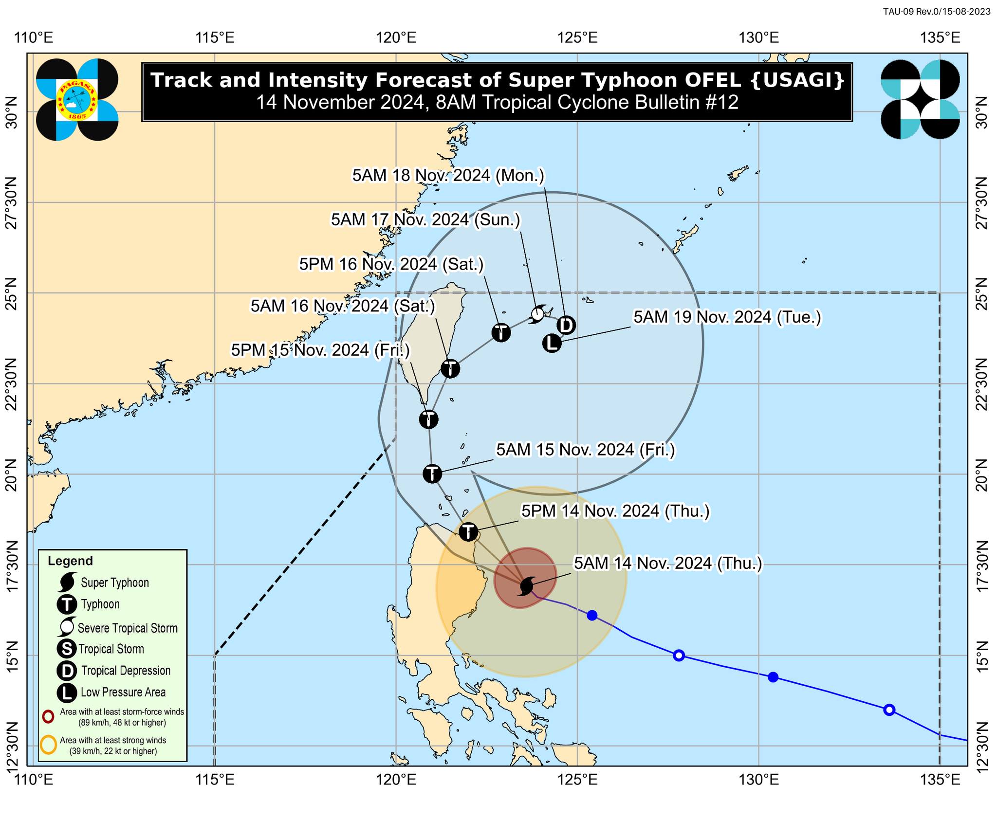
Ofel track and intensity – Typhoon Ofel (international name: Usagi) has reached super typhoon status, prompting the state weather bureau to raise Tropical Cyclone Wind Signal (TCWS) No. 5 in the northeastern portion of mainland Cagayan on Thursday morning, November 14, 2024. Photo from Pagasa
MANILA, Philippines — Typhoon Ofel (international name: Usagi) has reached super typhoon status, prompting the state weather bureau to raise Tropical Cyclone Wind Signal (TCWS) No. 5 in the northeastern portion of mainland Cagayan on Thursday morning.
Very strong winds greater than 185 kilometers per hour (kph) may be expected in areas under TCWS No. 5, the Philippine Atmospheric, Geophysical, and Astronomical Services Administration (Pagasa) said in its 8 a.m. bulletin.
It also said that Ofel’s latest location was marked 165 kilometers east-southeast of Tuguegarao City, Cagayan, packing maximum sustained winds of 185 kph and gustiness of up to 230 kph.
The super typhoon was moving northwestward at 15 kph, based on its latest track forecast.
READ: WALANG PASOK: Class suspensions for November 14 due to Ofel
Article continues after this advertisementOfel’s intensification likewise prompted Pagasa to raise TCWS No. 4 in three Northern Luzon areas:
Article continues after this advertisement- Southeastern portion of Babuyan Islands (Camiguin Island)
- Northern and eastern portions of mainland Cagayan (Santa Teresita, Ballesteros, Aparri, Camalaniugan, Buguey, Lal-Lo, Allacapan, Gattaran, Baggao, Peñablanca)
- Northeastern portion of Isabela (Maconacon, Divilacan, Palanan)
Strong winds between 118 kph up and 184 kph may be experienced in areas under TCWS No. 4, and affected residents were advised to take caution because very heavy damage to high-risk structures is possible.
The state weather agency also raised TCWS No. 3 over the following areas:
- Rest of Babuyan IslandsThe rest of Cagayan
- Northern, central, and southeastern portions of Isabela (San Pablo, Delfin Albano, Ilagan City, Tumauini, Cabagan, Santa Maria, Santo Tomas, San Mariano, Dinapigue)
- Northern portion of Apayao (Flora, Santa Marcela, Luna, Pudtol, Calanasan, Kabugao)
- Northern portion of Ilocos Norte (Pagudpud, Adams, Dumalneg)
Areas under TCWS No. 3 may expect winds ranging from 89 kph to 117 kph within the next 18 hours, according to Pagasa.
TCWS No. 2, which carries winds greater than 62 kph and up to 88 kph, was likewise hoisted over the following places:
- Batanes
- Western and southern portions of Isabela (Quezon, Quirino, Mallig, San Manuel, Aurora, Cabatuan, City of Cauayan, Benito Soliven, Naguilian, Gamu, Burgos, Reina Mercedes, Luna, Roxas, Angadanan, Alicia, San Guillermo, Echague, Jones, San Agustin, San Mateo, San Isidro),
Northeastern portion of Quirino (Maddela) - Rest of Apayao
- Kalinga
- Northeastern portion of Abra (Tineg, Lacub, Malibcong, Lagayan, San Juan, Lagangilang, Licuan-Baay, Daguioman)Eastern portion of Mountain Province (Paracelis)
- Eastern portion of Ifugao (Alfonso Lista)
- Rest of Ilocos Norte
- Northern portion of Aurora (Dilasag)
READ: Heavy rainfall warnings up over parts of Northern Luzon
Pagasa further declared TCWS No. 1 in the following areas:
- Rest of Isabela
- Rest of Quirino
- Nueva Vizcaya
- Rest of Mountain Province
- Rest of Ifugao
- Rest of Abra
- Northern portion of Benguet (Bokod, Mankayan, Kapangan, Atok, Kabayan, Kibungan, Bakun, Buguias, Tublay)
- Ilocos Sur
- Northern portion of La Union (Luna, Sudipen, Bangar, Santol, San Gabriel, Bagulin, Bacnotan, Balaoan, San Juan)
- Northern and central portions of Aurora (Casiguran, Dinalungan, Dipaculao, Maria Aurora, Baler, San Luis)
Areas under TCWS No. 1 are expected to experience strong winds of 39 kph to 61 kph, which pose minimal to minor threat to life and property.
Based on Pagasa’s latest forecast track, Ofel is still expected to move northwestward over the Philippine Sea before making landfall along the eastern coast of Cagayan or northern Isabela by Thursday afternoon.
“It will then emerge over Babuyan Channel tonight while making another landfall or passing close to Babuyan Islands,” the state weather bureau added.
However, Pagasa emphasized that hazards on land and coastal waters may still be experienced in areas outside the landfall point and the forecast confidence cone.
It reminded the public to remain vigilant for potential impacts, including strong winds, heavy rains, and possible storm surges.
A gale warning remains in effect over the northern and eastern seaboards of Northern Luzon and the eastern seaboard of Central Luzon, following Ofel’s intensification into a super typhoon.