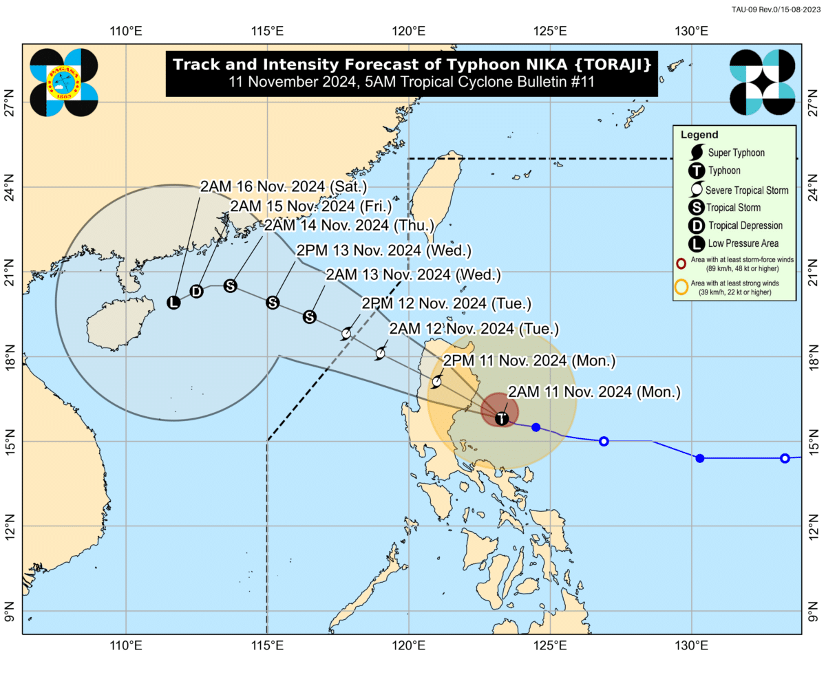
MANILA, Philippines — Several parts of northern Luzon were placed under Tropical Cyclone Wind Signal (TCWS) No. 4 as Nika (international name: Toraji) intensifies into a typhoon while moving west northwestward at 20 km/h over the Philippine Sea, the state weather bureau reported on Monday morning.
In its 5 a.m. bulletin, the Philippine Atmospheric, Geophysical and Astronomical Services Administration said Typhoon Nika was last spotted 100 km east southeast of Casiguran, Aurora and is expected to make landfall over Isabela or northern Aurora this morning.
It was packing maximum sustained winds of 120 km/h near the center and gustiness of up to 150 km/h.
Due to these developments, the following areas in Luzon were placed under TCWS No. 4:
- The northernmost portion of Aurora (Dilasag, Casiguran)
- the central and southern portions of Isabela (Dinapigue, San Mariano, San Guillermo, Jones, Echague, Ramon, San Isidro, City of Santiago, Cordon, Roxas, Burgos, Reina Mercedes, Naguilian, Benito Soliven, Gamu, San Manuel, Aurora, San Mateo, Cabatuan, Alicia, Luna, City of Cauayan, Angadanan, Quezon, Mallig, Quirino, Ilagan City, Delfin Albano, San Agustin),
- the southeastern portion of Abra (Tubo, Boliney, Daguioman, Bucloc, Malibcong),
- the central and eastern portions of Mountain Province (Sadanga, Bontoc, Barlig, Natonin, Paracelis),
- the eastern portion of Ifugao (Aguinaldo, Mayoyao, Alfonso Lista), and
- the western and southern portions of Kalinga (Tanudan, Tinglayan, Pasil, Lubuagan, Balbalan, City of Tabuk)
Areas under TCWS No. 4 may experience winds greater than 118 km/h and up to 184 km/h for at least 12 hours.
Meanwhile, the following Luzon areas were placed under TCWS No. 3:
- the northern portion of Aurora (Dinalungan),
- the northeastern portion of Nueva Vizcaya (Diadi, Bagabag, Quezon, Solano, Villaverde, Kasibu, Ambaguio, Bayombong),
- the northern portion of Quirino (Diffun, Cabarroguis, Aglipay, Saguday, Maddela),
- the rest of Isabela,
- the southwestern portion of Cagayan (Enrile, Solana, Tuao, Tuguegarao City, Rizal, Piat),
- the rest of Abra, the southern portion of Apayao (Conner, Kabugao), the rest of Kalinga,
- the rest of Mountain Province, the rest of Ifugao, the northern portion of Benguet (Buguias, Mankayan, Bakun),
- the southern portion of Ilocos Norte (Laoag City, Sarrat, San Nicolas, Piddig, Marcos, Nueva Era, Dingras, Bacarra, Solsona, Paoay, Currimao, Pinili, Badoc, City of Batac, Banna),
- and Ilocos Sur
These areas under TCWS No. 3 may experience winds greater than 89 km/h up to 117 km/h, and which may last for at least 18 hours.
The following areas on the other hand were placed under TCWS No. 2:
- The central portion of Aurora (Dipaculao, Maria Aurora, Baler),
- the rest of Nueva Vizcaya,
- the rest of Quirino,
- the northwestern and eastern portions of Cagayan (Iguig, Peñablanca, Baggao, Alcala, Amulung, Santo Niño, Gattaran, Lasam, Santa Praxedes, Claveria, Sanchez-Mira, Pamplona, Abulug, Allacapan, Ballesteros, Lal-Lo, Aparri, Camalaniugan, Buguey, Santa Teresita, Gonzaga),
- the rest of Apayao, the rest of Benguet,
- the rest of Ilocos Norte, La Union,
- the northeastern portion of Pangasinan (San Nicolas, Natividad, San Quintin, Sison, San Manuel, Umingan, Tayug), and
- the northern portion of Nueva Ecija (Carranglan, Pantabangan, Lupao, San Jose City)
These areas under TCWS No. 2 may experience winds greater than 62 km/h and up to 88 km/h, lasting for at least 24 hours.
On the other hand, the following areas were placed under TCWS No. 1
- The rest of Aurora,
- the rest of Cagayan including Babuyan Islands,
- the rest of Pangasinan,
- the rest of Nueva Ecija, Bulacan, Pampanga, Tarlac,
- the northern and central portions of Zambales (Santa Cruz, Candelaria, Masinloc, Palauig, Iba, Botolan, Cabangan, San Marcelino, San Felipe, San Narciso),
- Metro Manila,
- Rizal,
- the eastern portion of Laguna (Santa Maria, Mabitac, Pakil, Pangil, Famy, Siniloan, Paete, Kalayaan, Cavinti, Lumban, Luisiana, Santa Cruz, Magdalena, Pagsanjan, Majayjay, Liliw, Nagcarlan, Pila, Victoria),
- the northern and eastern portions of Quezon (Calauag, Infanta, Quezon, Alabat, Sampaloc, Mauban, Perez, Real, General Nakar, Tagkawayan, Guinayangan) including Pollilo Islands,
- Camarines Norte, and
- the northeastern portion of Camarines Sur (Siruma, Tinambac, Garchitorena, Lagonoy)
These areas under TCWS No. 1 may experience winds of 39-61 km/h, which may last for at least 36 hours. Intermittent rains may also be expected within 36 hours.
Pagasa added that Typhoon Nika is expected to traverse the landmass of mainland Luzon today and emerge over the sea west of Ilocos Sur this evening.