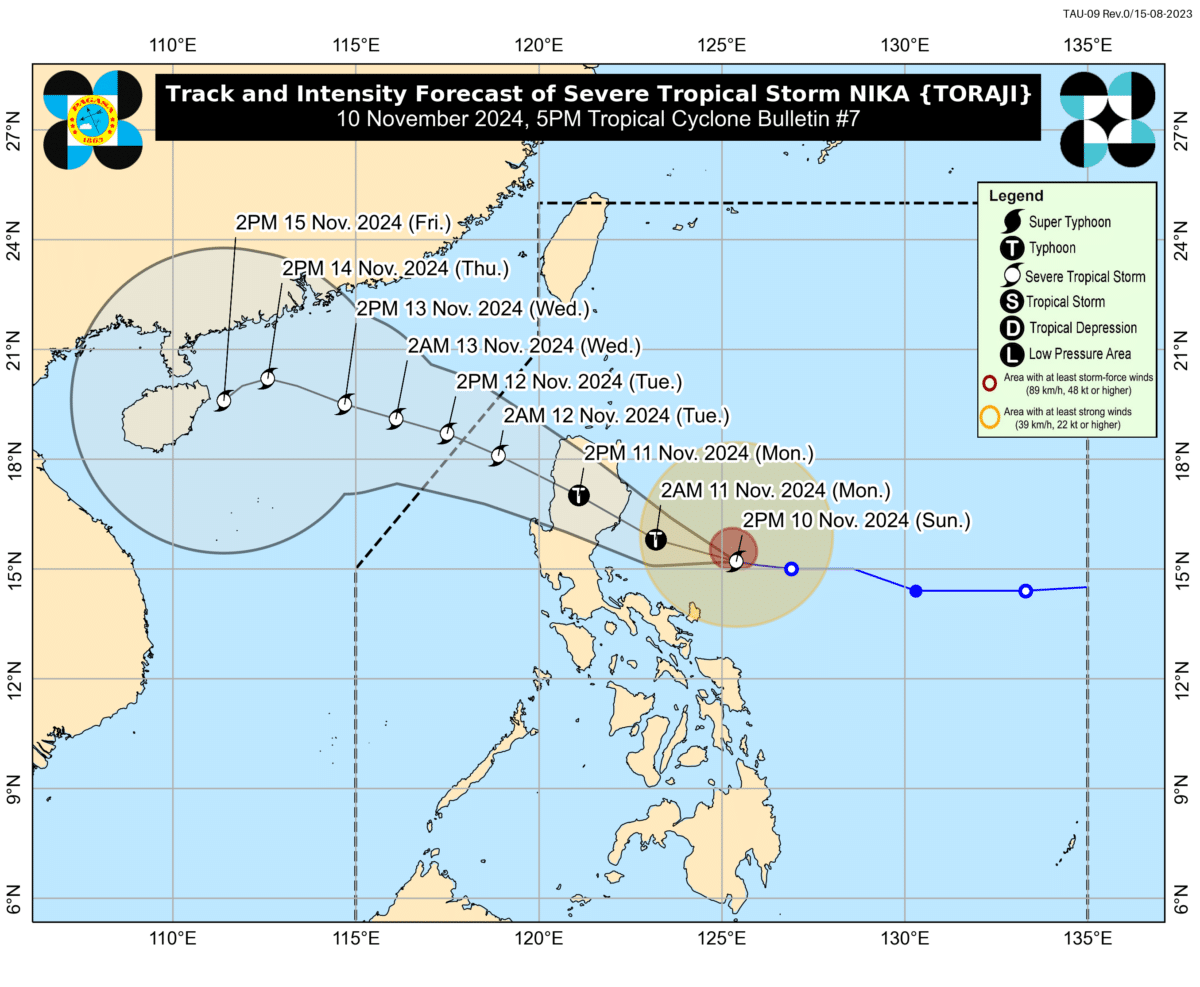
Image from the Philippine Atmospheric, Geophysical, and Astronomical Services Administration.
MANILA, Philippines — Tropical Storm Nika (international name: Toraji) was nearing typhoon strength as it moved westward on Sunday afternoon, the state weather bureau said.
In its 5 p.m. bulletin, the Philippine Atmospheric, Geophysical, and Astronomical Services Administration (Pagasa) said Nika was last spotted 380 kilometers (km) east of Infanta, Quezon.
It was packing maximum sustained winds of 110 kilometers per hour (kph) near its center. It had a gustiness of up to 135 kph as it moved westward at 20 kph.
Nika is forecast to intensify to around 130 kph before making landfall over Isabela or northern Aurora on Monday morning or early afternoon, marking its peak intensity, according to Pagasa.
“The tropical cyclone will then traverse the landmass of mainland northern Luzon and emerge over the West Philippine Sea tomorrow (November 11) evening,” the state weather bureau said.
Nika would continue moving west northwestward over the West Philippine Sea and exit the Philippine Area of Responsibility by Tuesday afternoon, the agency added.
Tropical Cyclone Wind Signals (TCWS) remain hoisted over many parts of the country.
TCWS No. 2 was raised over the following areas, where winds of greater than 62 kph and up to 88 kph may be expected in at least 24 hours:
- The northern portion of Aurora (Dilasag, Casiguran, Dinalungan, Dipaculao, Maria Aurora, Baler)
- Isabela
- Quirino
- Southern portion of mainland Cagayan (Solana, Iguig, Peñablanca, Tuguegarao City, Enrile, Baggao, Alcala, Amulung, Santo Niño, Rizal, Piat, Tuao, Gattaran, Lasam), Nueva Vizcaya, the southern portion of Apayao (Kabugao, Conner, Flora, Pudtol)
- Abra
- Kalinga
- Mountain Province
- Ifugao
- Benguet
- Northern portion of Nueva Ecija (Carranglan, Pantabangan, Lupao, San Jose City)
- Southern portion of Ilocos Sur (Narvacan, Nagbukel, Cervantes, Quirino, San Emilio, Santa Maria, Burgos, San Esteban, Santiago, Lidlidda, Banayoyo, City of Candon, Galimuyod, Salcedo, Gregorio del Pilar, Sigay, Santa Lucia, Santa Cruz, Suyo, Alilem, Tagudin, Sugpon)
- La Union
- Northeastern portion of Pangasinan (San Nicolas, Natividad, San Quintin, Sison, San Manuel, Umingan, Tayug)
Meanwhile, the following areas were placed under TCWS No. 1:
- The rest of Cagayan including Babuyan Islands
- The rest of Apayao
- Ilocos Norte
- The rest of Ilocos Sur
- The rest of Pangasinan
- The rest of Aurora, Tarlac
- Northern and central portions of Zambales (Santa Cruz, Candelaria, Masinloc, Palauig, Iba, Botolan, Cabangan, San Marcelino, San Felipe, San Narciso)
- The rest of Nueva Ecija
- Pampanga
- Bulacan
- Metro Manila
- Rizal
- Eastern portion of Laguna (Santa Maria, Mabitac, Pakil, Pangil, Famy, Siniloan, Paete, Kalayaan, Cavinti, Lumban, Luisiana, Santa Cruz, Magdalena, Pagsanjan, Majayjay, Liliw, Nagcarlan, Pila, Victoria)
- Eastern portion of Quezon (Calauag, Guinayangan, Tagkawayan, Pitogo, San Andres, Buenavista, San Francisco, Pagbilao, Infanta, Lopez, Catanauan, Mulanay, Unisan, General Luna, Plaridel, Quezon, Alabat, Sampaloc, Padre Burgos, Macalelon, Mauban, Perez, Agdangan, Gumaca, Atimonan, Real, San Narciso, General Nakar, Lucban, City of Tayabas, Lucena City) including Polillo Islands
- Camarines Norte
- Camarines Sur
- Catanduanes
- Northeastern portion of Albay (Malinao, Tiwi, Bacacay, City of Tabaco, Malilipot, Rapu-Rapu)
Intermittent rains and winds of 39 to 61 kph may be expected in areas under TCWS No. 1 within the next 36 hours.
“The public and disaster risk reduction and management offices concerned are advised to take all necessary measures to protect life and property,” Pagasa said.
A gale warning was also raised over the eastern seaboard of Luzon due to Nika’s intensification, deeming sea travel risky for all types of vessels.
READ: Tropical Storm Nika may cause storm surge in 13 Luzon provinces