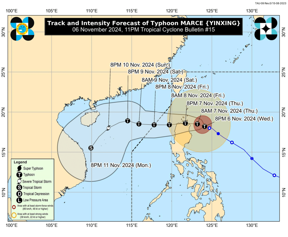
Track and intensity forecast of Typhoon Marce (international name: Yinxing) as of 11 p.m., November 6, 2024. —Photo from Pagasa/Facebook)
MANILA, Philippines — Typhoon Marce (international name: Yinxing) may have reached its peak intensity with Tropical Cyclone Wind Signal (TCWS) No. 3 hoisted over parts of northern Cagayan, the weather bureau said.
In its 11 p.m. weather bulletin, the Philippine Atmospheric, Geophysical and Astronomical Services Administration (Pagasa) said that Marce further intensified as it sustained a maximum wind speed of 155 kilometers per hour (kph) and gustiness of up to 190 kph.
READ: Marce maintains strength over Cagayan waters; Signal No. 3 up in 2 areas
Marce was also last spotted 240 kilometers east of Aparri in Cagayan, moving west-northwestward at 10 kph
READ: LIST: Luzon areas to have moderate to torrential rains from Nov. 6-8
Further, TCWS No. 3 was raised over the following areas:
- Northern and central portions of mainland Cagayan (Santa Ana, Gonzaga, Lal-Lo, Santa Teresita, Buguey, Aparri, Camalaniugan, Allacapan, Gattaran, Lasam, Ballesteros, Baggao, Alcala, Santo Niño, Rizal, Abulug, Pamplona, Sanchez-Mira, Claveria, Santa Praxedes) including Babuyan Islands
- Eastern portion of Apayao (Flora, Santa Marcela, Luna, Pudtol)
TCWS No. 2
Luzon:
- Batanes
- Rest of mainland Cagayan
- Northern and central portions of Isabela (San Pablo, Santa Maria, Divilacan, Tumauini, Maconacon, Cabagan, Santo Tomas, Quezon, Palanan, Ilagan City, Mallig, Delfin Albano, Quirino, San Mariano, Gamu, Roxas, Naguilian, Burgos, Reina Mercedes, Benito Soliven, Luna, Aurora, San Manuel)
- Rest of Apayao
- Abra
- Kalinga
- Eastern and central portions of Mountain Province (Paracelis, Natonin, Barlig, Sadanga)
- Ilocos Norte
- Northern portion of Ilocos Sur (Sinait, Cabugao, San Juan, Magsingal, Santo Domingo, Bantay, San Iledefonso, San Vicente, Santa Catalina, City of Vigan, Narvacan, Caoayan, Santa, Nagbukel, Santa Maria, San Esteban, Santiago, Burgos, Banayoyo, Lidlidda, San Emilio)
TCWS No.1
Luzon:
- The rest of Ilocos Sur
- La Union
- The northern portion of Pangasinan (Bani, Bolinao, Anda, City of Alaminos, Agno, Sual, Labrador, Burgos, Mabini, Lingayen, Binmaley, Dagupan City, Mangaldan, San Fabian, San Jacinto, Pozorrubio, Sison, San Manuel, San Nicolas, Natividad, San Quintin, Tayug, Santa Maria, Binalonan, Asingan, Laoac, Manaoag, Mapandan, Santa Barbara, Calasiao, City of Urdaneta)
- Rest of Mountain Province
- Ifugao
- Benguet
- Rest of Isabela
- Quirino
- Nueva Vizcaya
- Northern and central portions of Aurora (Dilasag, Casiguran, Dinalungan, Dipaculao, Maria Aurora, Baler)
- Northern portion of Nueva Vizcaya (Carranglan)
Pagasa added, “[s]light weakening is expected due to possible interaction with the terrain of mainland Luzon during the landfall or close approach of MARCE.”
There is also a possibility that Marce will exit the Philippine area of responsibility by Friday evening.
Meanwhile, a storm surge warning is up for the next 48 hours over the low-lying or coastal communities of the following:
- Batanes
- Cagayan, including Babuyan Islands
- Isabela
- Ilocos Norte
- Ilocos Sur
- La Union
A gale warning is also up over the seaboards of Northern Luzon and the eastern seaboard of Central Luzon.

