Marce seen to reach typhoon category Nov 5, says Pagasa
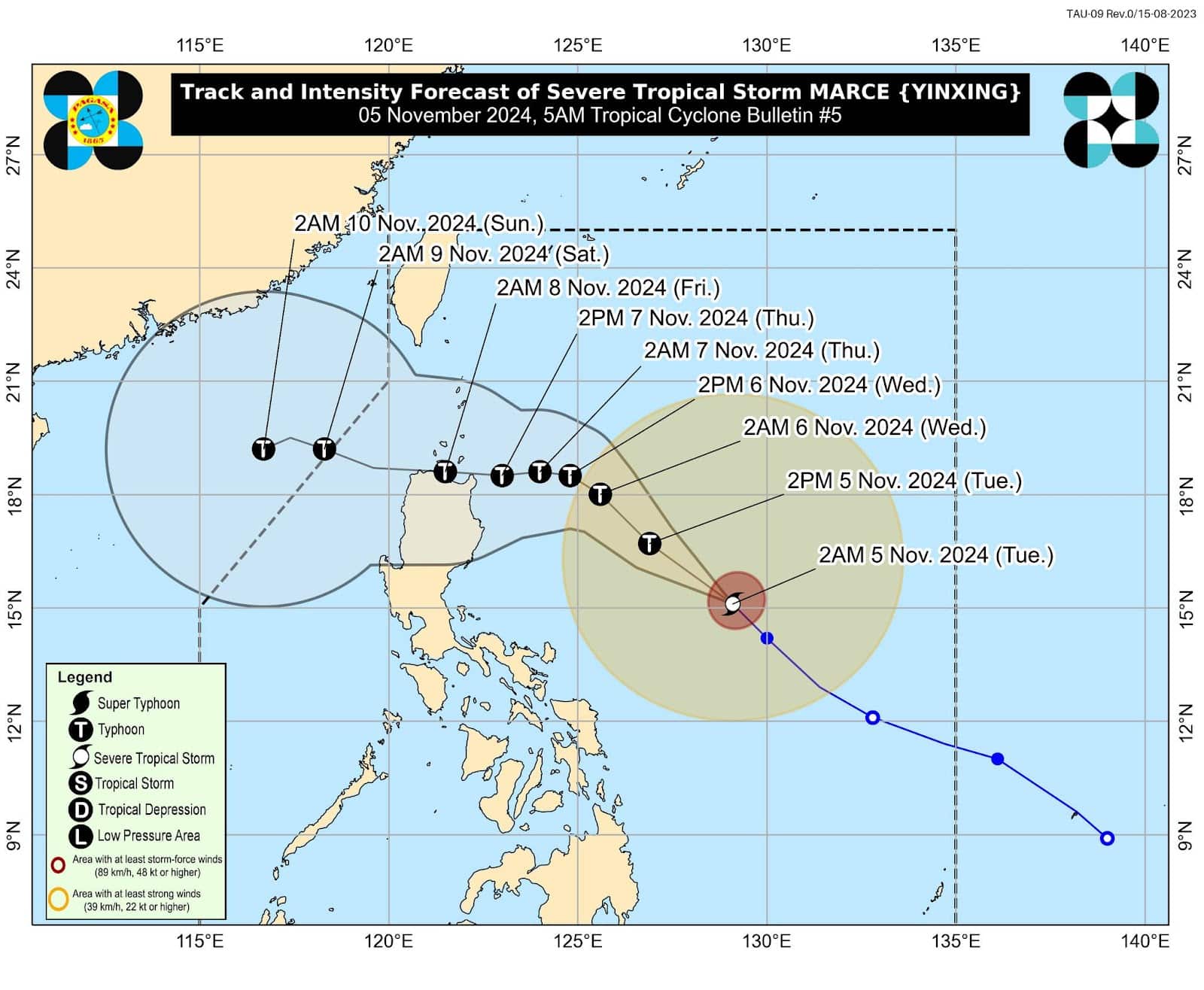
MANILA, Philippines — Severe Tropical Storm Marce (international name: Yinxing) slightly intensified on Tuesday morning, bringing it closer to typhoon status, according to the Philippine Atmospheric, Geophysical and Astronomical Services Administration (Pagasa).
“Marce may further strengthen today and reach the typhoon category until it exits our Philippine area of responsibility (PAR),” Pagasa weather specialist Rhea Torres said in mixed Filipino and English during a press briefing.
In a 5 a.m. bulletin, the state weather agency said Marce was last spotted 735 kilometers (km) east of Baler, Aurora. It was packing maximum sustained winds of 110 kilometers per hour (kph) near the center and gusts of up to 135 kph.
Marce was moving northwestward at 25 kph, it added.
Article continues after this advertisementREAD: Marce may become typhoon before Northern Luzon landfall
Article continues after this advertisementBased on the state weather bureau’s track forecast, Marce will move generally northwestward until Wednesday morning (November 6) before decelerating and turning westward over the Philippine Sea, east of extreme northern Luzon.
“Marce may make landfall in the vicinity of Babuyan Islands or over the northern portion of mainland Cagayan on Thursday evening or Friday early morning,” Pagasa said.
According to Torres, the radius of Marce is wide and will cover some portions of northern Luzon. She also said that the storm will gradually approach the Philippine landmass.
Due to these weather developments, Pagasa raised Tropical Cyclone Wind Signal No. 1 in the following areas:
- Batanes
- Cagayan including Babuyan Islands
- Northern and eastern portions of Isabela (Maconacon, San Pablo, Palanan, Dinapigue, Santa Maria, Cabagan, Tumauini, Santo Tomas, Ilagan City, Divilacan, San Mariano)
- Northern portion of Apayao (Santa Marcela, Luna, Calanasan, Flora, Pudtol)
- Northern portion of Ilocos Norte (Pagudpud, Dumalneg, Adams, Bangui, Burgos, Pasuquin, Vintar)
READ: Marce further intensifies; Signal No. 4 seen as highest wind signal
Pagasa said areas under TCWS No. 1 may anticipate winds of 39 kph to 61 kph within at least 36 hours.
Pagasa likewise hoisted a gale warning over the northern and eastern seaboards of Northern Luzon, particularly for the coasts of Batanes and, Cagayan including the Babuyan Islands, and Isabela.
Marce is expected to leave the PAR either Friday evening or Saturday morning, according to the state weather agency.
