Kristine maintains strength over southern Ilocos Sur waters
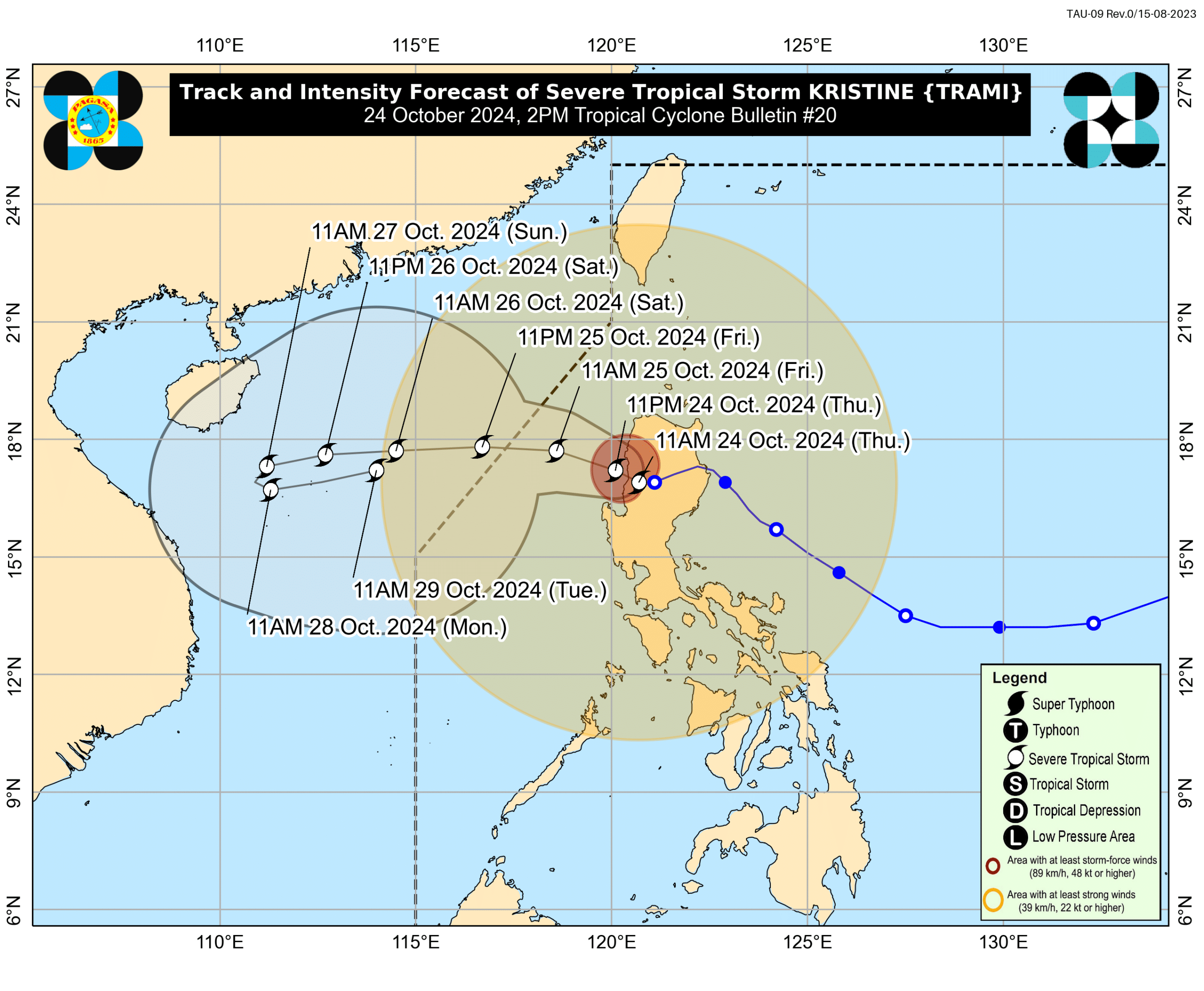
Track and Intensity Forecast of Severe Tropical Storm Kristine as of 2 p.m., October 24, 2024 (Image from DOST-Pagasa / Facebook)
MANILA, Philippines — Severe Tropical Storm Kristine (international name: Trami) maintained its strength as it remained over the waters of Southern Ilocos Sur, the state weather bureau said on Thursday.
In its 5 p.m. bulletin, the Philippine Atmospheric, Geophysical and Astronomical Services Administration (Pagasa) said that Kristine was last spotted over the waters of Santa Lucia, Ilocos Sur.
READ: Kristine maintains strength as it travels over Ilocos Sur – Pagasa
It was slowly moving westward while still packing up wind speed of 95 kilometers per hour (km/h) and gustiness of up to 145 km/h.
Pagasa said that Kristine “is forecast to move westward or west northwestward over the West Philippine Sea [WPS]” and is expected to re-intensify once it crosses over the WPS. Meanwhile, it will exit the Philippine area of responsibility on Friday afternoon.
Article continues after this advertisementMeanwhile, Pagasa noted that there is a “minimal to moderate risk of storm surge” in the next 48 hours over low-lying coastal communities of Ilocos Sur, La Union, Pangasinan, Cagayan, Isabela, Aurora, and Zambales.
Gale warning is also raised over the seaboards of Luzon and the western and central seaboards of Visayas.
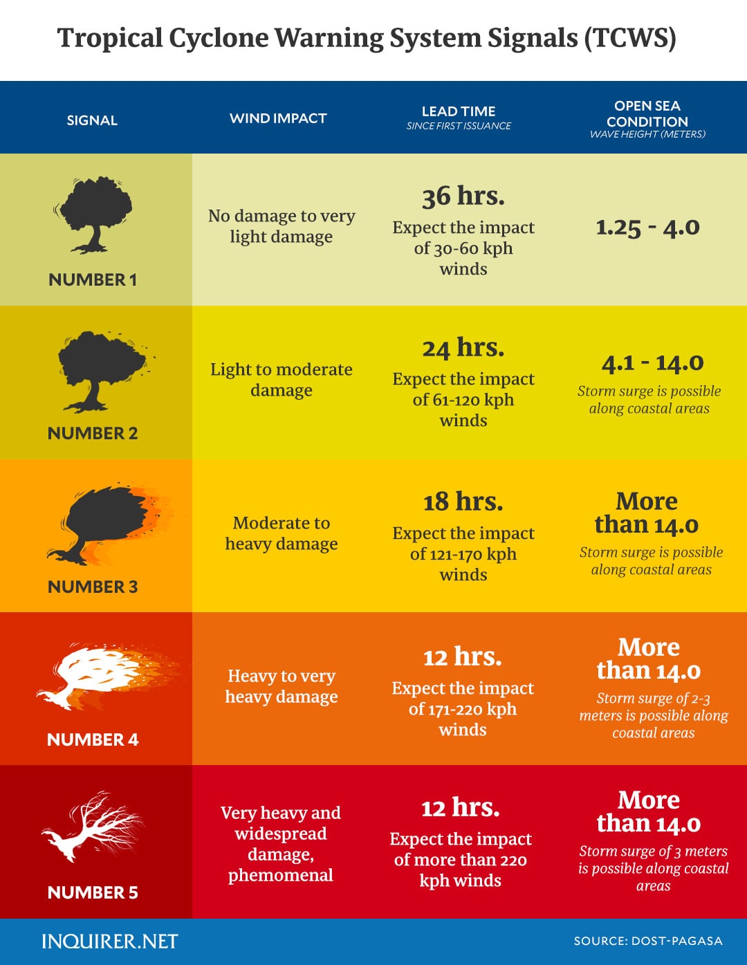
Further, the following Tropical Cyclone Wind Signals (TCWS) were hoisted over the following areas:
TCWS No.3
- Ilocos Sur
- La Union
- Pangasinan
TCWS No.2
Luzon
- Cagayan including Babuyan Islands
- Isabela
- Quirino
- Nueva Vizcaya
- Apayao
- Kalinga
- Abra
- Ifugao
- Mountain Province
- Benguet
- Ilocos Norte
- Aurora
- Nueva Ecija
- Tarlac
- Zambales
- Bataan
- Pampanga
- Bulacan
TCWS No.1
Luzon
- Batanes
- Metro Manila
- Batangas
- Laguna
- Cavite
- Quezon
- Occidental Mindoro
- Oriental Mindoro
- Marinduque
- Romblon
- Northern portion of mainland Palawan (El Nido, Taytay, Araceli, San Vicente, Dumaran, Roxas) including Calamian
- Islands, Cuyo, and Kalayaan Islands
- Camarines Norte
- Camarines Sur
- Catanduanes
- Albay
- Sorsogon
- Masbate including Ticao and Burias Islands
Visayas
- Aklan
- Capiz
- Antique including Caluya Islands
- Iloilo
- Bantayan Islands
- Northern Samar
- Northern portion of Samar (Calbayog City, Almagro, Tagapul-An, Santo Niño)
The National Disaster Risk and Reduction Management Council said on Thursday that seven persons were reported dead while more than two million people were affected by the storm.
READ: Kristine kills 7 persons, affects over 2 million people, says NDRRMC
The Office of Civil Defense said on Monday that Kristine may affect 30 million individuals, adding that “18,000 barangays are at risk of rain-induced landslides and floods, particularly in Central Visayas, Cordillera Administrative Region, Eastern Visayas, Ilocos Region, Mimaropa, Northern Mindanao, Soccsksargen (South Cotabato, Cotabato, Sultan Kudarat, Sarangani, General Santos), Western Visayas and Zamboanga Peninsula.”