Kristine now a severe tropical storm; Signal No. 3 in 12 Luzon areas
READ: LIVE UPDATES: Tropical Storm Kristine
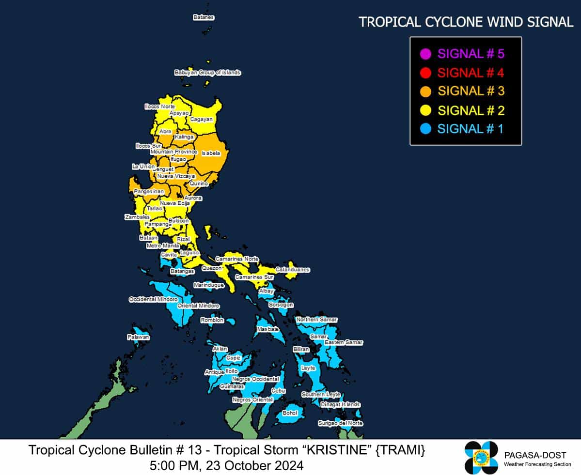
MANILA, Philippines — Erstwhile Tropical Storm Kristine (international name: Trami) has intensified into a severe tropical storm on Wednesday afternoon, which prompted the state weather bureau to raise Tropical Cyclone Wind Signal (TCWS) number 3 over twelve areas in Luzon.In its 5:00 p.m. bulletin, the Philippine Atmospheric, Geophysical and Astronomical Services Administration (Pagasa) said Kristine’s eye was last located some 175 kilometers east of Echague, Isabela, moving northwest at 20 kilometers per hour (kph) and carrying maximum sustained winds of 95 kph near the center with gusts of up to 115 kph.

GRPAHIC: Ed Lustan
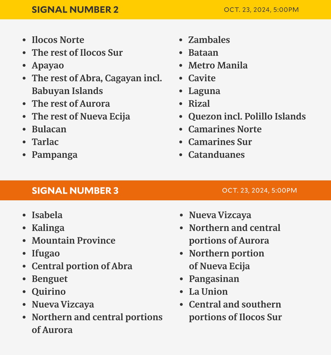
Signal No. 3 is up over the following areas:
- Isabela
- Kalinga
- Mountain Province
- Ifugao
- The central part of Abra (Malibcong, Licuan-Baay, Sallapadan, Daguioman, Bucloc, Boliney, Tubo, Luba, Manabo, Bucay, Villaviciosa, Pilar, San Isidro, Pe)
- Benguet
- Quirino
- Nueva Vizcaya
- Northern and central parts of Aurora (Dilasag, Casiguran, Dinalungan, Dipaculao, Maria Aurora, Baler)
- The northern part of Nueva Ecija (Carranglan, Lupao, San Jose City, Pantabangan), Pangasinan
- La Union
- The central and southern parts of Ilocos Sur (Cervantes, Quirino, Sigay, Suyo, Alilem, Sugpon, Tagudin, Santa Cruz, Salcedo, Gregorio del Pilar, San Emilio, Lidlidda, Burgos, San Esteban, Santiago, Banayoyo, Galimuyod, City of Candon, Santa Lucia, Nagbukel, Santa Maria, Narvacan)
Signal No. 2 is up over the following areas:
- Ilocos Norte
- The rest of Ilocos Sur
- Apayao
- The rest of Abra
- Cagayan including Babuyan Islands
- The rest of Aurora
- The rest of Nueva Ecija
- Bulacan
- Tarlac
- Pampanga
- Zambales
- Bataan
- Metro Manila
- Cavite
- Laguna
- Rizal
- Quezon including Polillo Islands
- Camarines Norte
- Camarines Sur
- Catanduanes
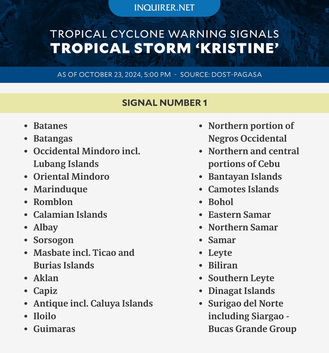
Signal No. 1 is up over the following areas:
- Batanes
- Batangas
- Occidental Mindoro including Lubang Islands,
- Oriental Mindoro
- Marinduque
- Romblon
- Calamian Islands
- Albay
- Sorsogon
- Masbate including Ticao and Burias Islands
- Aklan
- Capiz
- Antique including Caluya Islands
- Iloilo
- Guimaras
- The northern portion of Negros Occidental (Pontevedra, La Castellana, Moises Padilla, Bago City, La Carlota City, Valladolid, Pulupandan, Bacolod City, San Enrique, Murcia, Silay City, City of Talisay, Enrique B. Magalona, Manapla, City of Victorias, Cadiz City, Sagay City, City of Escalante, Toboso, Calatrava, Salvador Benedicto, San Carlos City)
- The northern portion of Negros Oriental (Vallehermoso, Canlaon City, City of Guihulngan)
- The northern and central portions of Cebu (Alcantara, Argao, Dumanjug, Sibonga, Pinamungahan, Ronda, Liloan, Cebu City, Moalboal, Consolacion, Danao City, Borbon, Carmen, Daanbantayan, Tuburan, City of Bogo, Tabogon, City of Naga, Lapu-Lapu City, City of Carcar, Mandaue City, Catmon, Minglanilla, Toledo City, Cordova, Compostela, San Remigio, Balamban, Aloguinsan, San Fernando, Asturias, Barili, Medellin, Sogod, Tabuelan, City of Talisay) including Bantayan Islands and Camotes Islands,
- Bohol
- Eastern Samar
- Northern Samar
- Samar
- Leyte
- Biliran
- Southern Leyte
- Dinagat Islands
- Surigao del Norte including Siargao – Bucas Grande Group
GRAPHIC: Ed Lustan
READ NEXT
EDITORS' PICK