Kristine remains strong over Aurora, Quezon; Signal No. 2 up in 26 areas

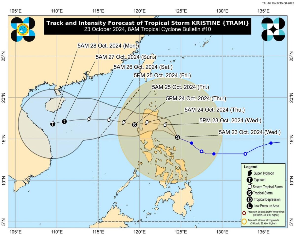
Track of storm Kristine as of 8 am of Wednesday, October 23, 2024 from Pagasa.
MANILA, Philippines — Tropical storm Kristine maintained its strength as it moved west northwestward over Quezon.
26 areas have been placed under Tropical Cyclone Wind Signal (TCWS) No. 2.
In its 8 a.m. weather bulletin, the Philippine Atmospheric, Geophysical and Astronomical Services Administration (Pagasa) said that Kristine was last located 310 kilometers east of Baler, Aurora or 310 km east northeast of Infanta, Quezon.

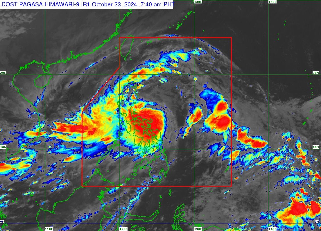
Satellite image of Storm Kristine from Pagasa as of 8 am of Wednesday, October 23, 2024
The storm is moving west northwestward at 15 kilometers per hour (km/h).
It was still packing its wind speed of 85 km/h and gustiness of up to 105 km/h.
Article continues after this advertisementREAD: 26 areas placed under storm signal number 2 as Kristine gets nearer
Article continues after this advertisementThe following areas are under TCWS No.2:
- Ilocos Norte
- Ilocos Sur
- La Union
- Pangasinan
- Apayao
- Abra
- Kalinga
- Mountain Province
- Ifugao
- Benguet
- Mainland Cagayan
- Isabela
- Quirino
- Nueva Vizcaya
- Aurora
- Nueva Ecija
- Bulacan
- Tarlac
- Pampanga
- Zambales
- Northern and eastern portions of Quezon (Infanta, General Nakar, Real, Mauban, Perez, Alabat, Quezon, Calauag, Tagkawayan, Guinayangan) including Polillo Islands
- Camarines Norte
- Camarines Sur
- Catanduanes
- Albay
- Northeastern portion of Sorsogon (Prieto Diaz, City of Sorsogon)
Meanwhile, TCWS No. 1 is up in the following areas:
Luzon
- Batanes
- Babuyan Islands
- Bataan
- Metro Manila
- Rizal
- Cavite
- Rest of Quezon
- Occidental Mindoro including Lubang Islands
- Oriental Mindoro
- Marinduque
- Romblon
- Calamian Islands
- Rest of Sorsogon
- Masbate including Ticao and Burias Islands
- Laguna
- Batangas
Visayas
- Northern portion of Negros Occidental (Pontevedra, La Castellana, Moises Padilla, Bago City, La Carlota City, Valladolid, Pulupandan, Bacolod City, San Enrique, Murcia, Silay City, City of Talisay, Enrique B. Magalona, Manapla, City of Victorias, Cadiz City, Sagay City, City of Escalante, Toboso, Calatrava, Salvador Benedicto, San Carlos City)
- Northern portion of Negros Oriental (Vallehermoso, Canlaon City, City of Guihulgngan)
- Northern and central portions of Cebu (Alcantara, Argao, Dumanjug, Sibonga, Pinamungahan, Ronda, Liloan, Cebu City, Moalboal, Consolacion, Danao City, Borbon, Carmen, Daanbantayan, Tuburan, City of Bogo, Tabogon, City of Naga, Lapu-Lapu City, City of Carcar, Mandaue City, Catmon, Minglanilla, Toledo City, Cordova, Compostela, San Remigio, Balamban, Aloguinsan, San Fernando, Asturias, Barili, Medellin, Sogod, Tabuelan, City of Talisay)
- Bantayan Islands
- Camotes Islands
- Bohol
- Rest of Eastern Samar
- Rest of Northern Samar
- Samar
- Leyte
- Biliran
- Southern Leyte
Mindanao
- Dinagat Islands
- Surigao del Norte including Siargao – Bucas Grande Group
Landfall forecast
Pagasa said that Kristine is forecast to make landfall over Isabela or Northern Aurora on Wednesday night or Thursday early morning.
It is also expected to “gradually intensify” into a severe tropical storm category before it makes a landfall.
It may exit the Philippine area of responsibility by Friday.
Gale Warning
A gale warning is up in the seaboards of Luzon and Visayas.
The state weather bureau warned that “[s]ea travel is risky for all types or tonnage of vessels.”
The Office of Civil Defense said on Monday that Kristine may affect 30 million individuals, adding that “18,000 barangays are at risk of rain-induced landslides and floods, particularly in Central Visayas, Cordillera Administrative Region, Eastern Visayas, Ilocos Region, Mimaropa, Northern Mindanao, Soccsksargen (South Cotabato, Cotabato, Sultan Kudarat, Sarangani, General Santos), Western Visayas and Zamboanga Peninsula.”
READ: Number coding scheme suspended in Metro Manila on Wednesday, Oct 23