MANILA, Philippines — Super Typhoon Julian (international name: Krathon) was downgraded into the typhoon category on Wednesday morning, state meteorologists said.
Julian decelerated into a typhoon at 2:00 a.m., according to the Philippine Atmospheric, Geophysical and Astronomical Services Administration (Pagasa).
READ: Julian is now a super typhoon, says Pagasa
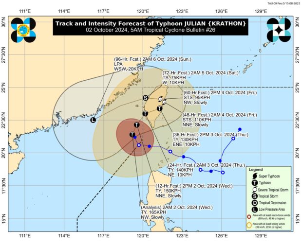
As of 4:00 a.m., the typhoon’s center was last spotted 280 km west-northwest of Itbayat, Batanes, packing maximum sustained winds of 165 kilometers per hour (kph) with gustiness of 205 kph.
Batanes, Babuyan Islands, the northern and western portions of Ilocos Norte, and the northwestern portion of mainland Cagayan are still under Tropical Cyclone Wind Signal No. 1, where 39 to 61 kph wind speed are expected.
This condition entails minimal to minor threats to life and property.
Julian is still outside the Philippine area of responsibility and is now heading towards Taiwan.
Pagasa said, “There is a significant change in the track forecast of Julian.”
“The typhoon is still forecast to turn northeastward towards the southwestern coast of Taiwan, where it is expected to make landfall tonight (Wednesday) or tomorrow early morning (Thursday),” Pagasa said.
“Julian is forecast to move erratically over the landmass and coastal waters of Taiwan before emerging over the Taiwan Strait on Friday evening or Saturday early morning,” it continued. “Afterwards, Julian will move southwestward over the Taiwan Strait and the waters south of mainland China.”
Julian is seen to weaken and may become a remnant low — referring to a former tropical cyclone that no longer has enough qualities to be considered such — over the weekend.
“Julian will continue to weaken due to a combination of incoming northeasterly wind flow over the East China Sea and Taiwan Strait and lower ocean heat content in its vicinity (which is related to upwelling of cooler waters caused by its slow movement for nearly two days),” Pagasa said.
“Further weakening is expected once Julian hits the landmass over Taiwan due to frictional effects,” it added.
