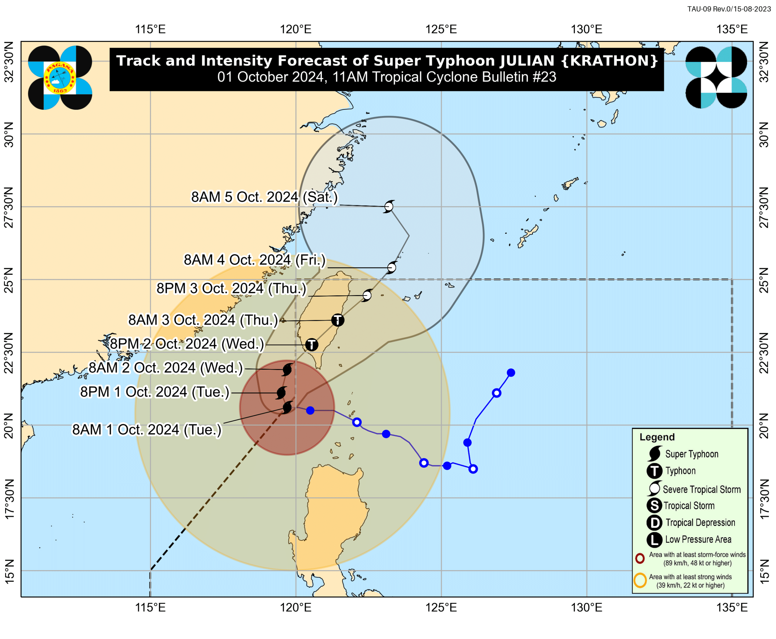

MANILA, Philippines — Super typhoon Julian slightly intensified after exiting the Philippine Area of Responsibility (PAR) at 9 a.m. Tuesday but may still re-enter on Wednesday, reported Philippine Atmospheric, Geophysical and Astronomical Services Administration (Pagasa) in its 11 a.m. bulletin on Tuesday.
“‘Yung kanyang mata ay nasa labas ng PAR, pero inaasahan natin na ito ay temporary o panandalian lamang na paglabas dahil we’re expecting a possible re-entry ng mata ni bagyong Julian sa ating area of responsibility most likely tomorrow,” state weather specialist Loriedin De La Cruz – Galicia said in its 11 a.m. press briefing.
(The eye is outside the PAR, but we expect this to be temporary as we’re anticipating a possible re-entry of Julian’s eye into our area of responsibility, most likely tomorrow.)
The super typhoon’s center was estimated 235 kilometers (km) west of Itbayat, Batanes as of 10 a.m., packing maximum sustained winds of 195 kilometers per hour (kph) and gusts of up to 240 kph, according to the state weather bureau.
Strong to typhoon-force winds may extend up to 630 km from the center as the typhoon moves westward slowly, Pagasa added.
State meteorologists said super typhoon Julian may intensify within the next 18 hours but may weaken slightly before making landfall as it approaches the mountains of Taiwan.
“Afterwards, increasing interaction with the mountainous terrain of Taiwan will slightly weaken Julian before making landfall. Its passage over Taiwan will result in Julian being downgraded into a severe tropical storm on Thursday,” the state weather bureau explained.
Pagasa forecast Julian to recurve towards the sea southwest of Taiwan from Monday to Tuesday morning.
“On the track forecast, the super typhoon will make landfall along the southwestern coast of Taiwan tomorrow (October 2) morning or afternoon. It will then cross the rugged terrain of Taiwan before emerging over the sea east of Taiwan on Thursday (3 October) morning,” Pagasa stated in its latest bulletin.
“Julian will move northeastward towards the East China Sea, and exit the Philippine Area of Responsibility on Thursday evening or Friday early morning, then turn northwestward on Friday evening to Saturday early morning once over the East China Sea,” they added.
Due to such developments, Pagasa updated the list of areas placed under Tropical Cyclone Wind Signals (TCWS):
TCWS No. 2
- Batanes
- Babuyan Islands
- Northern portion of Ilocos Norte (Bacarra, Pasuquin, Bangui, Vintar, Burgos, Pagudpud, Dumalneg, Adams)
- The northwestern portion of mainland Cagayan (Santa Praxedes, Claveria, Sanchez-Mira)
TCWS No. 1
- The rest of Ilocos Norte
- Ilocos Sur
- La Union
- Pangasinan
- Apayao
- Kalinga
- Abra
- Mountain Province
- Province of Ifugao
- Benguet
- The rest of mainland Cagayan
- Isabela
- Quirino
- Nueva Vizcaya
- Northern portion of Aurora (Dilasag, Casiguran, Dinalungan)
- Northern portion of Nueva Ecija (Carranglan, Lupao, Pantabangan)
A gale warning was also issued by Pagasa over the northern and western seaboards of Northern Luzon.