
Photo courtesy of Pagasa
MANILA, Philippines — Batanes remains under Tropical Cyclone Wind Signal (TCWS) No. 4 as Typhoon Julian is expected to reach the super typhoon category by Monday evening, according to the state weather bureau.
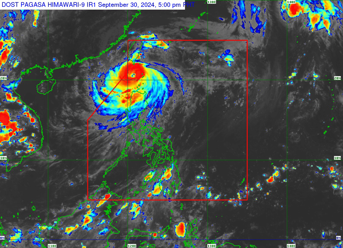
In its 5 p.m. cyclone update, the Philippine Atmospheric, Geophysical and Astronomical Services Administration (Pagasa) reported that Julian was last spotted 95 kilometers west southwest of Itbayat in Batanes.
It was moving west-northwestward at 15 kilometers per hour (kph), carrying maximum sustained winds of 175 kph and gusts of up to 215 kph.
Although Julian is already moving away from Batanes, Pagasa said it “will continue intensifying and may reach super typhoon category this afternoon or evening.”
The following areas remain under wind signals:
Signal No. 4
Batanes
Signal No. 3
The northern and western portions of Babuyan Islands (Babuyan Island, Calayan Island, Dalupiri Island, Fuga Island)
Signal No. 2
- The northern and westwern portion of Mainland Cagayan (Piat, Santo Nino, Camalaniugan, Tuao, Lal-Lo, Pamplona, Gonzaga, Alcala, Amulung, Santa Teresita, Baggao, Buguey, Solana, Rizal, Claveria, Gattaran, Iguig, Lasam, Aparri, Ballesteros, Abulug, Allacapan, Sanchez-Mira, Santa Praxedes, Santa Ana)
- The rest of Babuyan Islands
- Apayao
- Abra
- Kalinga
- Ilocos Norte
- The northern and central portions of Ilocos Sur (Sinait, Cabugao, San Emilio, Lidlidda, Banayoyo, Santiago, Santa Maria, Burgos, San Esteban, Nagbukel, Narvacan, Santa, Caoayan, Bantay, Santo Domingo, San Juan, San Vicente, San Ildefonso, Magsingal, Santa Catalina, City of Vigan)
Signal No. 1
- The rest of Ilocos Sur
- La Union
- Pangasinan
- Ifugao
- Mountain Province
- Benguet
- The rest of Mainland Cagayan (Peñablanca, Tuguegarao City, Enrile)
- Isabela
- Nueva Vizcaya
- Quirino
- The northern portion of Aurora (Dilasag, Casiguran, Dinalungan)
- The northern portion of Nueva Ecija (Carranglan, Lupao, Pantabangan)
Julian is expected to exit the Philippine Area of Responsibility (PAR) by Thursday.
“Julian is forecast to move generally westward to northwestward while decelerating over the Bashi Channel today and will begin recurving tomorrow (October 1) while moving slowly, then turn generally northeastward on Wednesday (October 2) towards the southwestern coast of Taiwan, where it is forecast to make landfall on Wednesday,” Pagasa said.
“The typhoon will then cross the rugged terrain of Taiwan and emerge over the waters east of Taiwan by Wednesday evening or Thursday (October 3) early morning,” it added.