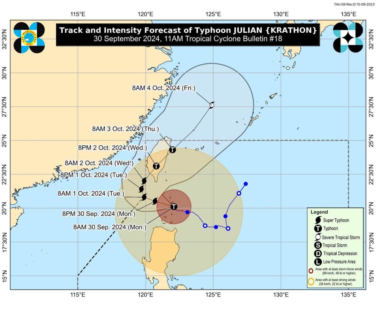

MANILA, Philippines — Typhoon Julian maintained its strength as it moved over the coastal waters of Batanes on Monday afternoon, the state weather bureau said.
In its 2 pm. bulletin, the Philippine Atmospheric, Geophysical and Astronomical Services Administration (Pagasa) said Julian was moving west-northwestward at 15 kilometers per hour (kph).
Julian was expected to be over the coastal waters of Sabtang Island, Batanes as of 1 p.m., state meteorologists said.
The typhoon carried maximum sustained winds of 175 kph near the center and gusts of up to 240 kph, an increase from the previous 215 kph.
“Julian is forecast to move generally west-northwestward to northwestward over the Bashi Channel today and will begin recurving tomorrow (October 1) while moving slowly,” Pagasa said.
Due to the ongoing effects of the typhoon, the state weather bureau updated Tropical Cyclone Wind Signals (TCWS) in the following areas:
TCWS No. 4
- Batanes
TCWS No. 3
- Babuyan Islands
TCWS No. 2
- Mainland Cagayan
- Apayao
- Abra
- Kalinga
- Ilocos Norte
- Northern and central portions of Ilocos Sur (Sinait, Cabugao, San Emilio, Lidlidda, Banayoyo, Santiago, Santa Maria, Burgos, San Esteban, Nagbukel, Narvacan, Santa, Caoayan, Bantay, Santo Domingo, San Juan, San Vicente, San Ildefonso, Magsingal, Santa Catalina, City of Vigan)
TCWS No. 1
- The rest of Ilocos Sur
- La Union
- Pangasinan
- Ifugao
- Mountain Province
- Benguet
- Isabela
- Nueva Vizcaya
- Quirino
- Northern and central portions of Aurora (Dilasag, Casiguran, Dinalungan, Dipaculao, Maria Aurora, Baler, San Luis), and the northern and eastern portions of Nueva Ecija (Cuyapo, Rizal, Laur, Pantabangan, Science City of Muñoz, Gabaldon, Carranglan, San Jose City, Lupao, Talugtug, Bongabon, Llanera, Talavera, Palayan City, General Mamerto Natividad)
Pagasa also raised a storm surge warning at 2 p.m. in the provinces of Batanes, Cagayan, and Ilocos Norte.
Estimated storm surge heights are from 2.1 to 3 meters, according to the same forecast.
“A moderate to high risk of storm surge may occur within the next 48 hours. There is a possibility of inundation due to rising sea water along with high waves in the low-lying communities in the municipalities of Basco, Itbayat, Ivana, Mahatao, Sabtang, and Uyugan in Batanes; Abulug, Aparri, Ballesteros, Buguey, Calayan, Claveria, Gonzaga, Pamplona, Sanchez Mira, Santa Ana, and Santa Praxedes in Cagayan; and Pagudpud in Ilocos Norte,” Pagasa said.