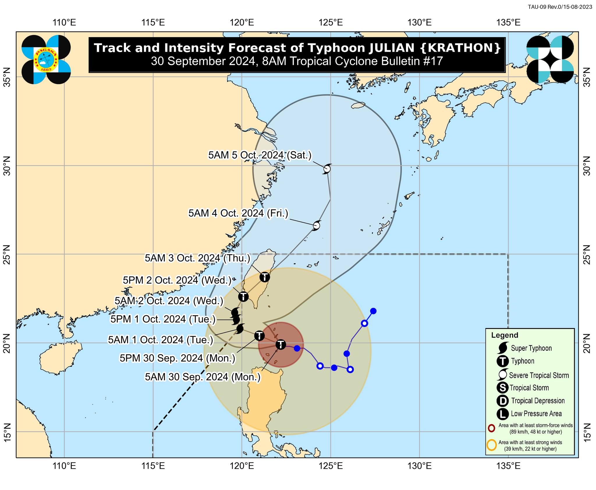

MANILA, Philippines — Typhoon Julian has further intensified and is nearing the super typhoon category, the Philippine Atmospheric, Geophysical and Astronomical Services Administration (Pagasa) said on Monday.
In its 8 a.m. cyclone update, Pagasa said Julian was last spotted over the coastal waters of Balintang Island in Calayan, Cagayan.
READ: Various LGUs suspend classes for Sept 30 due to typhoon Julian
It is moving west-northwestward at 10 kilometers per hour (kph), packing maximum sustained winds of 175 kph near the center and gusts of up to 215 kph.
“Julian will continue intensifying and may reach the super typhoon category tomorrow,” said Pagasa’s forecast.
“Interaction with the rugged terrain of Taiwan will trigger a weakening trend prior to landfall, although Julian is forecast to remain as a typhoon until it exits the Philippine area of Responsibility,” it noted.
Julian is forecast “to generally move west-northwestward over the Balintang Channel today and pass very close to Balintang Island and Batanes. A landfall scenario over these areas remains likely,” said the weather bureau.
The following areas remain under wind signals:
Signal No. 4
- Batanes
- northern portion of Babuyan Islands: Babuyan Island and Calayan Island)
Signal No. 3
- rest of the Babuyan Islands
- northeastern portion of mainland Cagayan: Santa Ana
Signal No. 2
- rest of mainland Cagayan
- Apayao
- northern portion of Abra: Tineg, Lacub, Malibcong, Licuan-Baay San Juan, Lagayan, Lagangilang, Dolores, Daguioman, Danglas, La Paz
- northern portion Kalinga: Pinukpuk, Balbalan, City of Tabuk, Rizal
- Ilocos Norte
- northern portion of Ilocos Sur: Sinait, Cabugao
Signal No. 1
- rest of Ilocos Sur
- La Union
- Pangasinan
- rest of Abra
- rest of Kalinga
- Ifugao
- Mountain Province
- Benguet
- Isabela
- Nueva Vizcaya
- Quirino
- Aurora
- northern and eastern portions of Nueva Ecija: Cuyapo, Rizal, Laur, Pantabangan, Science City of Muñoz, Gabaldon, Carranglan, San Jose City, Lupao, Talugtug, Bongabon, Llanera, Talavera, Palayan City, General Mamerto Natividad
- Polillo Islands