Weather disturbance Julian intensified into a typhoon on Sunday and was expected to make landfall or come in close contact with Babuyan Islands or mainland Batanes province on Monday, the Philippine Atmospheric, Geophysical and Astronomical Services Administration (Pagasa) said.
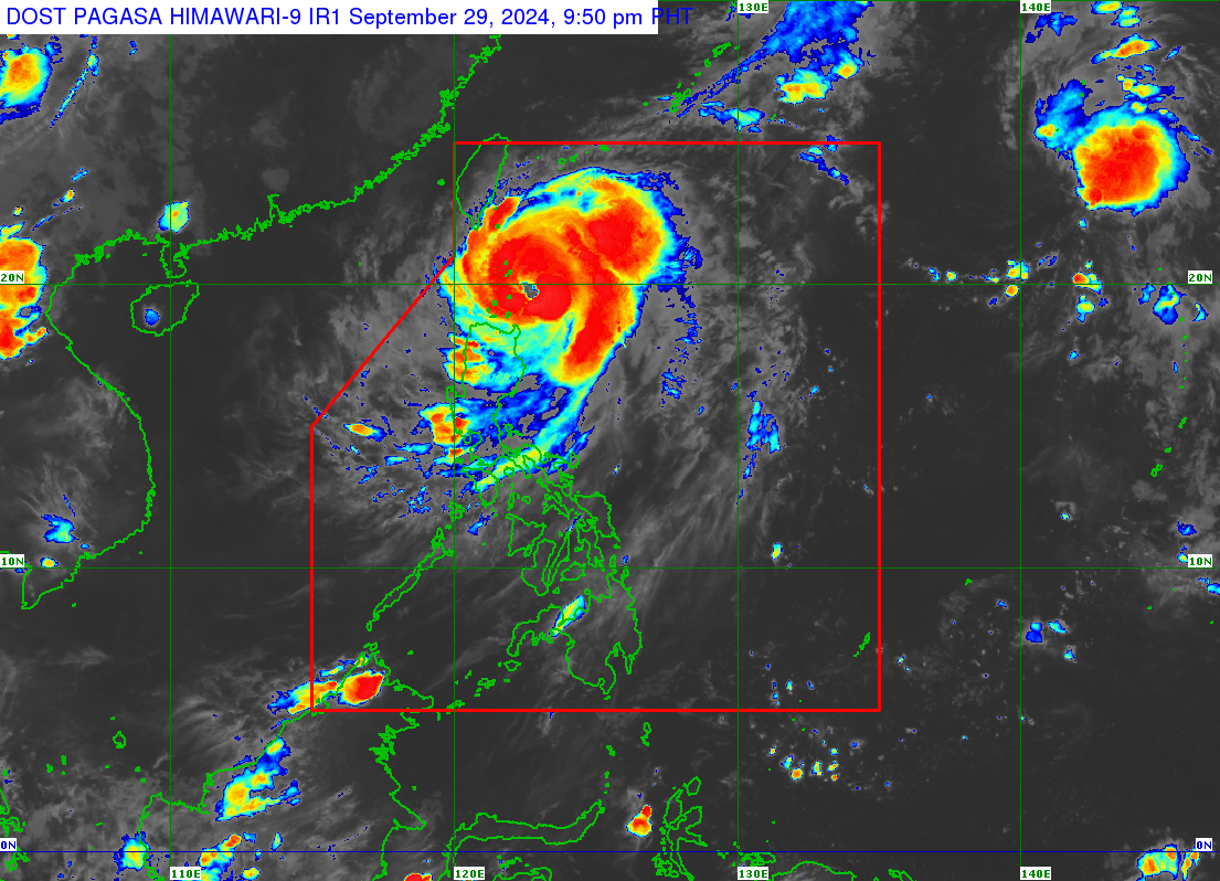
MANILA, Philippines — The weather bureau’s 5 p.m. bulletin on Sunday said Typhoon Julian (international name: Krathon) was located 235 kilometers east of Calayan, Cagayan province, with maximum sustained winds of 120 km per hour (kph) near the center and gustiness of up to 150 kph.
Tropical cyclone wind signal (TCWS) No. 3 was raised in Batanes and the northeastern portion of the Babuyan Islands. Placed under TCWS No. 2 were mainland Cagayan, the rest of Babuyan Islands, Apayao, and the northern and central portions of Ilocos Norte.
TCWS No. 1 was hoisted over the rest of Ilocos Norte, Ilocos Sur, La Union, Abra, Kalinga, Ifugao, Mountain Province, Benguet, Isabela, Nueva Vizcaya, Quirino, and the northern and central portions of Aurora.
Torrential rainfall would be felt in Ilocos Norte until Monday afternoon and until Tuesday in Batanes and Babuyan Islands, Pagasa added.
Heavy to intense rainfall was forecast over mainland Cagayan until Monday and in Ilocos Sur and Abra until Tuesday; and moderate to heavy rainfall in Mountain Province, Pangasinan, Zambales, and Bataan until Monday, and in Apayao, La Union and Benguet up to Tuesday.
Pagasa said the typhoon was moving north-northwestward at 15 km/h toward the waters east of Taiwan and was projected to exit the Philippine area of responsibility (PAR) on Thursday.
The weather bureau was also monitoring Tropical Storm Jebi, currently outside PAR at 2,010 km east northeast of extreme northern Luzon as of 3 p.m. on Sunday.
Jebi was moving north-northwestward at 25 km/h, with a maximum winds of 75 km/h and gustiness of up to 90 km/h.
On alert
In Cagayan Valley, the Regional Disaster Risk Reduction and Management Council (RDRRMC) went on a “red alert” on Sunday as it braced for Julian.
The RDRRMC said Batanes, Isabela, and Cagayan’s towns of Calayan and Santa Ana were on red alert (all human and material resources are made available for immediate deployment); the rest of Cagayan and Quirino were on blue alert (response agencies shall place their respective emergency operations centers on 24/7 operation); and Nueva Vizcaya remained on white alert (on standby).
The typhoon was expected to swell the Magat River (covering Ifugao, and parts of Nueva Vizcaya and Isabela), Cagayan River (traversing the Cordillera, Ilocos, and Cagayan Valley Regions), and Pinacanauan River (Cagayan province), authorities said.
No evacuation has yet been reported but disaster risk reduction and management offices in northern Luzon have been on alert.
On Sunday, a “no sail, no fish” rule and a liquor ban were in effect in Isabela and Cagayan.
Heavy rains spawned by Julian have also prompted the National Irrigation Administration (NIA) to release water, at 164 cubic meters per second, from Magat Dam, located in the boundary of Ifugao and Isabela.
Carlo Ablan, NIA-Magat River Integrated Irrigation System dam, and reservoir division manager, said they anticipated the heavy volume of water from the dam’s watersheds and had informed nearby communities of the water release.