
Image from DOST / Pagasa
MANILA, Philippines — Severe tropical storm Julian has developed into a typhoon on Sunday afternoon, reported the Philippine Atmospheric, Geophysical and Astronomical Services Administration (Pagasa).
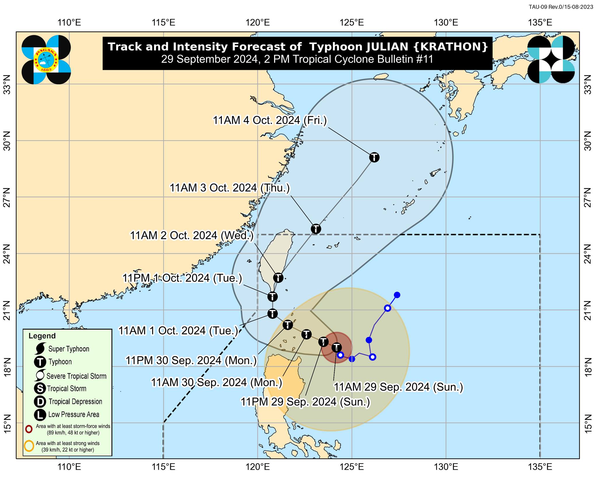
As of 1 p.m., Julian’s center is located 275 kilometers (km) east of Calayan, Cagayan, packing maximum sustained winds of 120 kilometers per hour (kph) near the center and gustiness of up to 135 kph, according to the state weather bureau’s 2 p.m. bulletin.
It is currently moving north northwestward at 15 kph with strong to storm-force winds extending outwards up to 490 km from the center, Pagasa added.
Signal no. 3 is still up in the northeastern portion of Babuyan Islands, while the following areas are under wind signal no. 2:
- Batanes
- Mainland Cagayan
- The rest of Babuyan Islands (Camiguin Is., Calayan Is., Dalupiri Is., Fuga Is.)
- Apayao
- Northern and central portions of Ilocos Norte (Pagudpud, Adams, Dumalneg, Bangui, Burgos, Pasuquin, Vintar, Carasi, Nueva Era, Solsona, Piddig, Dingras, Sarrat, San Nicolas, Laoag City, Bacarra)
Gale-force winds ranging from 62 kph to 88 kph may be experienced in the said areas within the next 24 hours, the state weather bureau noted.
Meanwhile, Pagasa hoisted wind signal no. 1 in the following areas:
- The rest of Ilocos Norte
- Ilocos Sur
- The northern portion of La Union (Santol, Sudipen, Bangar, Luna, Balaoan, San Gabriel, Bacnotan)
- Abra
- Kalinga
- Ifugao
- Mountain Province
- Northern and central portions of Benguet (Bakun, Mankayan, Buguias, Kabayan, Atok, Kibungan, Bokod, Kapangan)
- Isabela
- Nueva Vizcaya
- Quirino
- Northern and central portions of Aurora (Dilasag, Casiguran, Dinalungan, Dipaculao)
According to Pagasa, intermittent rains may be expected in these areas within 36 hours.
The state weather bureau forecasts that the highest wind signal likely to be raised during the occurrence of Julian is wind signal no. 4.
READ: Severe storm Julian further intensifies, signal no. 3 up in Babuyan Islands
A gale warning has been issued for the northern and eastern seaboards of Northern Luzon, deeming sea travel risky for small sea crafts and all types of motorbancas.