
State weather bureau Pagasa releases heavy rainfall warning on 2 a.m., Tuesday, Sept. 3, 2024. —Photo from Pagasa/Facebook
MANILA, Philippines — Zambales and other parts of Luzon will experience heavy rainfall on Tuesday morning, according to the Philippine Atmospheric, Geophysical, and Astronomical Services Administration (Pagasa).
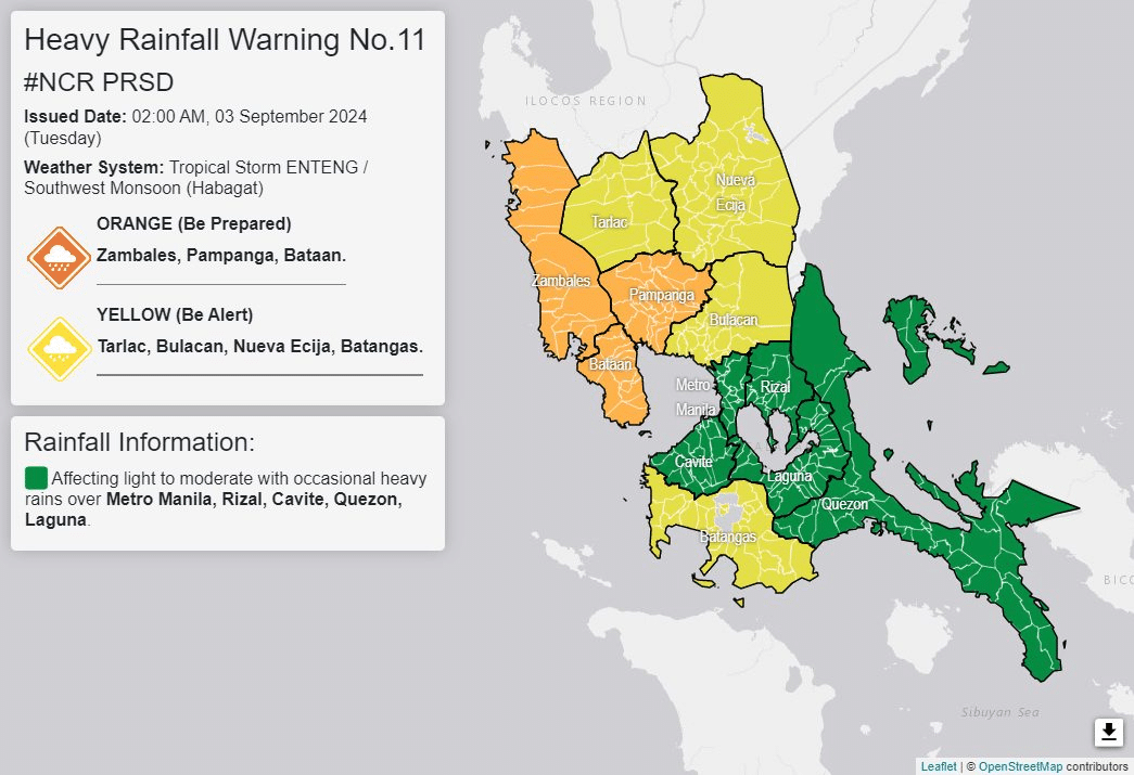
In its 2 a.m. rainfall warning advisory, Pagasa reported that orange rainfall alert was still raised in Zambales while Pampanga and Bataan were added to the list. Flooding is “still threatening” as areas under the orange rainfall warning will experience between 15 millimeters (mm) and 30 mm rainfall for the next two hours.
READ: Heavy rainfall warning up in Zambales, other areas
Meanwhile, Tarlac and Nueva Ecija were still placed under yellow rainfall warning while Bulacan was added under the rainfall alert where flooding in flood-prone areas is likely. Areas under the yellow rainfall warning will have between 7.5 mm and 15 mm of rain for the next two hours.
For emergency: government hotlines
Pagasa said that light to moderate with occasional heavy rains will affect Metro Manila, Rizal, Cavite, Quezon, and Laguna and may persist within three hours.
In its 2 a.m. weather bulletin, the center of Enteng was seen at Kabuyao, Apayao as it moved northwestward with a speed of 20 kilometers per hour (km/h). It has maximum sustained winds of 75 km/h with gustiness of up to 125 km/h.
According to Pagasa, the tropical storm is forecast to intensify its tropical storm category by Tuesday up to Thursday.
Tropical Cyclone Wind Signals (TCWS) are declared in the following areas:
TCWS No. 2
- Ilocos Norte
- Northern part of Ilocos Sur (Sinait, Cabugao, San Juan, Magsingal, Santo Domingo, San Ildefonso, San Vicente, Santa Catalina, City of Vigan, Bantay, Santa, Caoayan)
- Apayao
- Abra
- Kalinga
- Mountain Province
- Ifugao
- Cagayan including Babuyan Islands
- Northern and central portions of Isabela (Santo Tomas, Alicia, San Mateo, Aurora, Santa Maria, Quezon, San Mariano, Ramon, Naguilian, Roxas, San Guillermo, Luna, Delfin Albano, City of Cauayan, Echague, San Pablo, Ilagan City, Angadanan, Benito Soliven, City of Santiago, Tumauini, Cabagan, Reina Mercedes, San Manuel, Cabatuan, Quirino, Divilacan, Gamu, San Isidro, Mallig, Cordon, Jones, Maconacon, Burgos, San Agustin)
- Northern part of Quirino (Cabarroguis, Diffun, Aglipay, Saguday)
- Northern part of Nueva Vizcaya (Diadi, Bagabag)
TCWS No.1
- Batanes
- The rest of Ilocos Sur
- La Union
- Benguet
- The rest of Isabela
- The rest of Nueva Vizcaya
- The rest of Quirino
- Northern and central portion of Aurora (Casiguran, Dilasag, Dinalungan)
- Northeastern portion of Nueva Ecija (Carranglan, Pantabangan, Bongabon)