Northern Samar seeks geopark title for rock formations
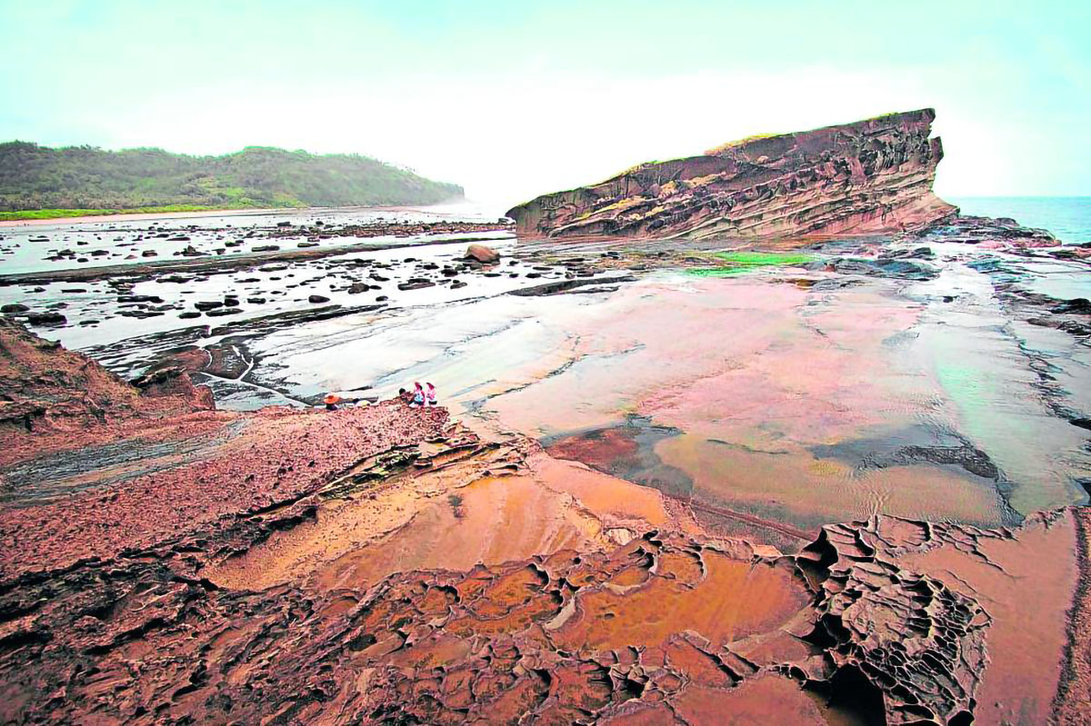
FORGED BY NATURE The rock formations in Biri, Northern Samar—formed as a result of tectonic movements, wave actions and weathering—are among the tourism jewels of Eastern Visayas region. The provincial government has nominated these natural wonders to become the country’s next Unesco global geopark after Bohol. —photo courtesy of Department of Tourism-Eastern Visayas
TACLOBAN CITY, LEYTE, Philippines — The popular rock formations on Biri Island in Northern Samar have been nominated by the provincial government for consideration as the country’s second “global geopark” recognized by the United Nations Educational, Scientific and Cultural Organization (Unesco) after the island province of Bohol.
Ivan Anthony Henares, secretary general of Unesco National Commission of the Philippines, led a group of experts who assessed the Biri rock formations in Barangay Progress on May 23.
READ: Value of Unesco World Heritage Site inscription
According to the Unesco, a global geopark is a single, unified geographical area where sites and landscapes have international geological significance.
Local officials are hopeful that the Biri rock formations will pass the requirements and earn the prestigious title of global geopark.
Article continues after this advertisement“We believe that Biri’s majestic rock formations are places of outstanding geological heritage. This will support sustainable development through conservation, education, community engagement and sustainable tourism,” Carl Sanchez Bordeos, culture and art coordinator of the Northern Samar provincial tourism office, told the Inquirer.
Article continues after this advertisementAccording to information from the provincial government, the rock formations in Biri, about 38 kilometers away from the provincial capital of Catarman, were formed as a result of centuries of natural processes, including tectonic movements, wave actions and weathering.
Ecotourism site
“The formations exhibit a variety of sedimentary and volcanic features, making them a valuable resource for scientific study and a captivating destination for ecotourism,” Bordeos said.
Seven rock formations are found in the area. Locals named these as Magasang, Magsapad, Macadlaw, Puhunan, Caranas, Pinanahawan and Bel-at, where a natural pool could be found.
“These rock formations were formed millions of years ago, which means it has [a] superior geological, natural and cultural heritage,” Bordeos said. “And with this, we would like to protect this natural heritage and share them with the world.”
The town of Biri faces the Pacific Ocean and San Bernardino Strait.
“That is why, Biri Island also has cultural and historical significance not only for the province and the Philippines but also in world history, most especially during the Manila Galleon trade,” Bordeos said.
Vicky Mabutin, tourism officer of Biri, said they were excited about the prospect of the rock formations being recognized by the Unesco.
“The rock formations are our town’s tourism gem. Last year alone, over 5,000 tourists visited the place,” she said.