Rediscovering Cagayan de Oro
HISTORIC SITES Visitors to Cagayan de Oro will learn more about the city by spending their time in historical landmarks, such as the Kiosko Kagawasan. — PHOTOS BY BOBBY LAGSA
CAGAYAN DE ORO CITY—As people approach the main city center of Cagayan de Oro from the south along the national highway, a giant clay jar will greet them at a junction in Barangay Bulua.
Ordinarily, the area is known to locals as banga, a starting point for jeepneys plying routes toward the city center. The structure was built to symbolize Bulua’s pottery industry that has endured until today.
For those who marvel at travels down memory lane, the banga opens a window of curiosity into Cagayan de Oro’s rich history, oftentimes taken for granted even by its over 700,000 people, much less the more than 300,000 people who do business here in the daytime.
The first settlement here was recorded around the 1620s and grew into a town in 1871. What used to be the municipality of Cagayan de Misamis in Misamis Oriental province became Cagayan de Oro City in 1950.
Apart from being the administrative seat of Northern Mindanao, Cagayan de Oro is also the region’s leading economic engine with its vibrant retail trade and powerhouse capacity for tourism and events.
To give visitors a more nuanced experience of the city, the Department of Tourism (DOT) launched the Cagayan de Oro City Historical Tourism Trail, in cooperation with the office of Rep. Rufus Rodriguez, himself a history buff.
The tour circuit is composed of 29 historical sites spread across the city, among these the Saint Augustine Metropolitan Cathedral, monuments, parks and museums.
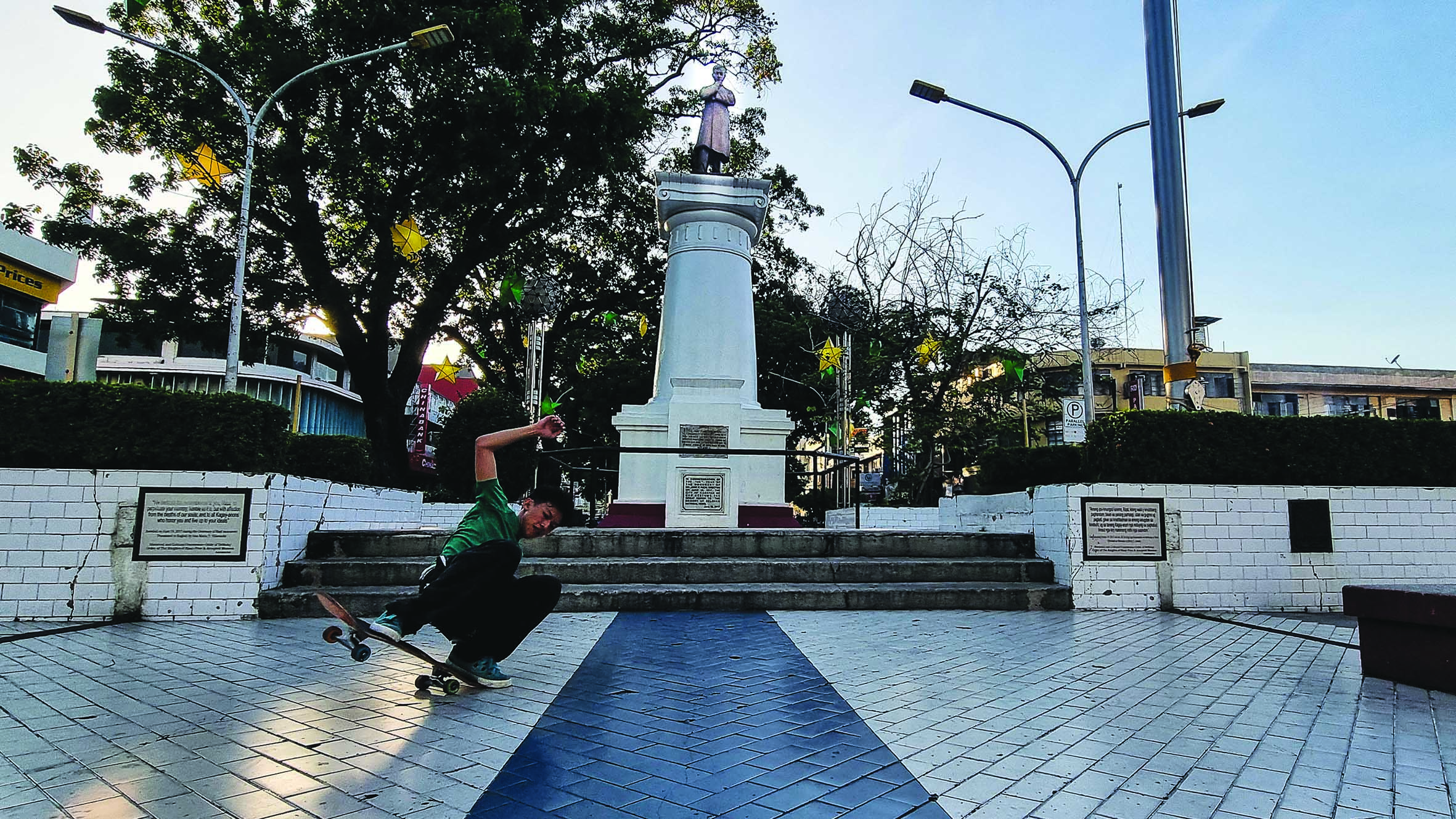
Rizal monument, in Plaza Divisoria
Uptown trail
Starting from the city’s uptown district, tourists can find Plaza de los Heroes along the busy Masterson Avenue.
The park has a small obelisk with the names of the heroes of the Philippine-American War in the 1900s inscribed on it. It tells the story of brave Kagay-anons who fought for the country’s independence against American colonizers.
About 8 kilometers south of Plaza de los Heroes is the Macahambus Cave where the Americans suffered a battlefield setback against Filipino soldiers led by Col. Apolinar Velez and Lt. Cruz Taal. The cave is open daily for tourists to visit.
City center attractions
The trail starts at the Saint Augustine Metropolitan Cathedral, home of the city’s patron. Beside the church is the Nuestra Señora del Santisimo Rosario, simply referred to by the faithful as Birhen sa Kota (Virgin of the Fort). The shrine displays a wooden image of the Blessed Virgin Mary presented with Madonna and with the Child Jesus in her arms.
Across the cathedral is Gaston Park, named after Mayor Segundo Gaston who commissioned the landscaping of the largest and oldest public park in the city. Constructed in 1623, the park was built as part of a wooden fort by Fray Agustin de San Pedro.
It attracts thousands of people daily, especially during weekends when throngs stop by after attending Holy Mass, providing food vendors good business. At night, Gaston Park brightens up with thousands of lights.
Beside the park is the Water Tower which was constructed in 1922 and built by the Americans to provide water to residents. In 2008, the interiors of the water tower were renovated and converted into a museum.
To the west of Gaston Park is the Ysalina Bridge that connects the two main sides of the city across the mighty Cagayan (de Oro) River. It is a favorite Instagram-worthy site as it turns into a landscape of bright colors at night.
Right beside the Ysalina Bridge is the City Hall, used to be called Casa Real, an edifice that burned down in 1910. To mark the building’s historical importance, two markers were erected beside it, one by the Cagayan de Oro Historical and Cultural Commission, and another by the National Historical Commission of the Philippines.
Duaw Park is just across City Hall. The park is covered by a giant acacia tree, drawing visitors who love to sip coffee right beside the river.
In front of the City Hall stands what used to be the Cagayan de Oro Maternity-Children’s Hospital and Puericulture Center. In the American era, there used to be Club Popular there where Kagay-anons and Misamisnons gathered and signed the pact of resistance against the colonial occupation.
At the corner of Velez and Hayes Streets is the Balay nga Bato (or stone house) of Sia Ygua, built in 1882 from bricks imported from southern China. Local revolutionaries and their supporters assembled outside the house on Jan. 10, 1899, for a grand parade in support of Gen. Emilio Aguinaldo’s declaration of Philippine independence.
During the American occupation, the house was used as headquarters of the US 40th Regiment. As such, it was the target of an attack by the resistance fighters’ Mindanao Battalion, led by Gen. Nicolas Capistrano, on April 7, 1900. The locals who died in battle were buried in graves at the back of the house.
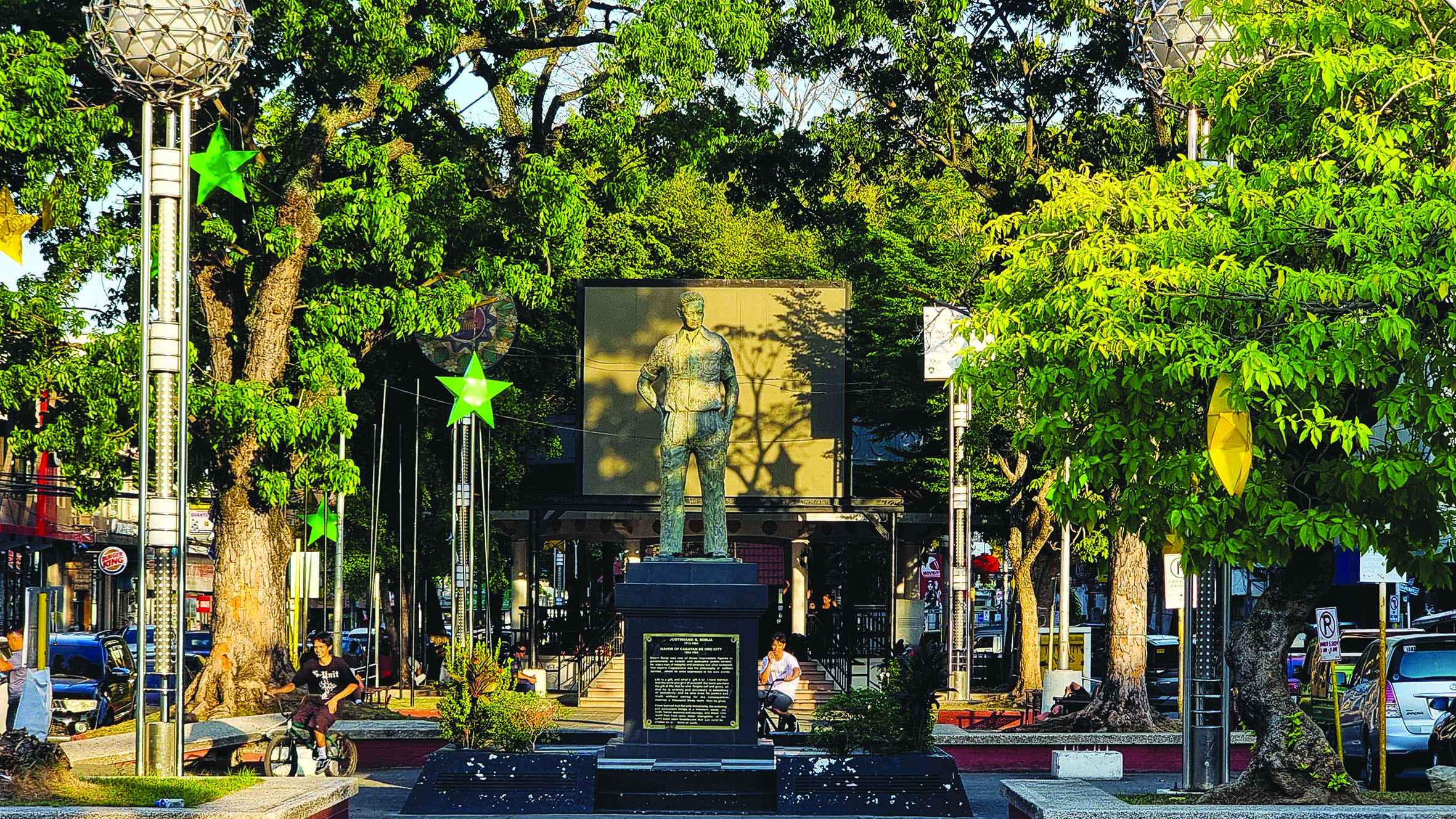
Plaza Divisoria and its immediate environs is considered the poblacion of the city. It consists of a series of six tree-covered parks that have monuments of heroes. There is the 108-year-old Jose Rizal monument, that of the late Mayor Justiniano Borja, one that honors the 1st Company of the Mindanao Battalion who died at the Battle of Agusan Hill, and of Ramon Magsaysay.
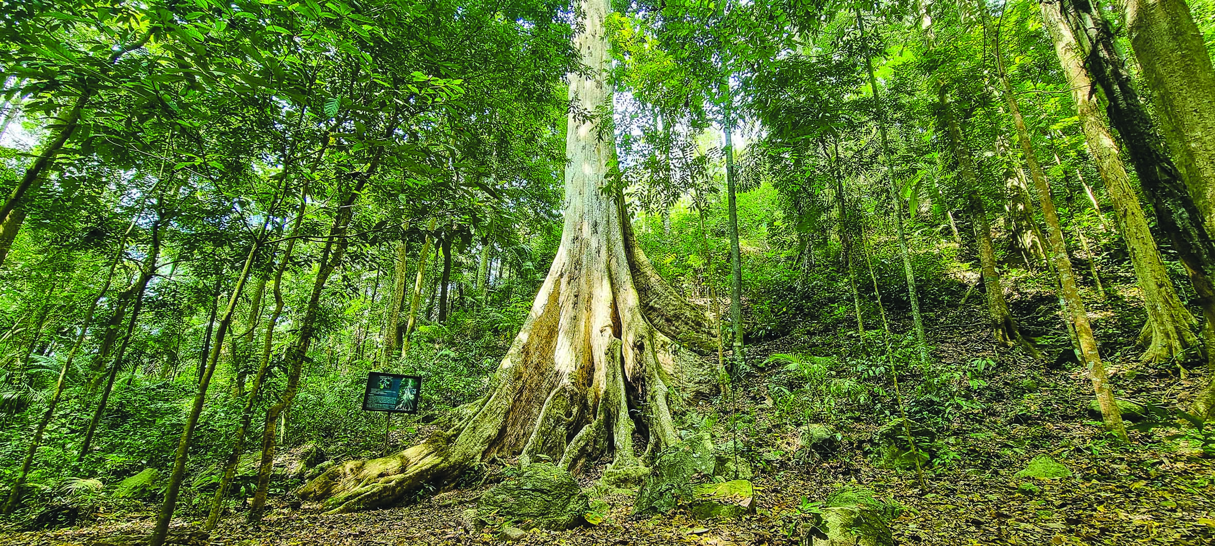
300-year-oldDao tree inside the Malasag eco-park.
Museums, history
Because of the tall mahogany trees that lined Plaza Divisoria, it has become a favorite spot for pause and rest amid the bustle of urban life. In the afternoon, youngsters converge in the park for skateboarding and bike stunts. Dance sport enthusiasts and street dancers use the Kiosko Kagawasan (Freedom Kiosk) as their practice stage. If you fancy Latin dances, this is where to spot future dance sport champions. The Kiosko is also a venue for free concerts and rallies.
The museums trail jumps off with the Xavier University (XU)-Ateneo de Cagayan heritage zone which comprises the Museo de Oro, the XU Science Center Building, the Lucas Hall, the Immaculate Conception Church, and the XU Library.
The 114-year-old administrative building of the Misamis Oriental General Comprehensive High School, the city’s biggest public high school, and the equestrian statue of the late Gov. Apolinar Velez are also interesting stops.
Capitol University’s Museum of Three Cultures was established in 2008. It preserves and exhibits cultural and historical artifacts of the three distinct cultural groupings of Northern Mindanao — the migrants, the lumad (indigenous peoples), and the Maranao.
The La Castilla Museum is the Pelaez family museum that houses heirlooms and antiques of the family of Rodolfo and Elsa Pelaez.
The structure is the summer residence of the founders of Liceo de Cagayan University. Inside the museum are wares, letters, paintings, purses and framed pictures, decorative items, dresses and gowns by Filipino fashion designers, toys, and vintage technology.
War memorial
The MacArthur Memorial Marker is the spot where Gen. Douglas MacArthur, his family and staff landed on March 13, 1942, in Barangay Macabalan, after escaping from Corregidor Island in Bataan aboard three PT (patrol, torpedo) boats.
From the port, MacArthur proceeded to Del Monte Lodge in Manolo Fortich, Bukidnon. Four days later, on March 17, 1942, MacArthur’s party was fetched by two B-17 bombers and brought to Australia.
The Heroes Hill in Barangay Agusan is where Captain Vicente Roa and his men fought the Americans during the Filipino-American War. They were defeated by the Americans in the fiercest local battle and their remains were buried at the hill. Their remains were later transferred to the Heroes Monument in Plaza Divisoria in 1931.
At the Philippine Air Force’s Lumbia Airport is the Japanese War Memorial of the 12th Hikoh-Daitai. The memorial was built at the airport as it was the Japanese Imperial Army that first developed the facility as a fighter plane airstrip in 1943.
Heritage tree
One’s trip into the city’s past can be capped by a visit to the 300-year-old Dao tree inside the Malasag eco-park forest, one of the city’s watershed areas. The tree stands 49 meters high and has a diameter of 2.28 meters, which will take about 30 people with outstretched arms to surround the tree.
Getting to the Dao tree is a commune with nature. The 10-km trek through the Malasag eco-trail is a favorite for hikers and bikers. The lush forest provides a cool breeze and shade. During the Holy Week, at least 200,000 Catholic devotees do their lent pilgrimage at the Malasag eco-park.
According to Marie Elaine Unchuan, DOT regional director, this new tourism offering caters to tourists who are interested in historical sites.
“This is one way to give our tourists a historical overview of our rich culture and heritage,” Unchuan said, adding that this innovation is just in time for Northern Mindanao’s playing host to this year’s Philippine Travel Expo.
“We want to make this one of our most popular tours, not only because we want to increase tourism arrivals, but we would like to have our tourists appreciate the history of the city,” she added.