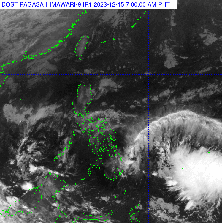
LPA off Mindanao may enter PAR in 24 hours, possible to become tropical cyclone

The low pressure area east of Southeastern Mindanao as seen on the Dec. 15, 2023 satellite image of the Philippines. (Photo from Pagasa)
MANILA, Philippines — The low-pressure area (LPA) off Mindanao forecast to enter the Philippine area of responsibility (PAR) may intensify into a tropical cyclone, the state weather bureau said on Friday.
According to the Philippine Atmospheric, Geophysical, and Astronomical Services Administration (Pagasa), the LPA was last seen 1,595 kilometers east of Southeastern Mindanao. It is expected to enter the PAR on Saturday.
“Papasok po ito ng Philippine area of responsibility bukas po, araw ng Sabado. Kaya posible nga po na ito ay maging isang ganap na bagyo,” weather specialist Obet Badrina reported in their morning weather forecast.
(It will enter the Philippine area of responsibility tomorrow, Saturday. It may become a tropical cyclone.)
If it enters the PAR and becomes a tropical cyclone, Badrina said the weather system will be called “Bagyong Kabayan.” It will be the first one for the month of December.
Article continues after this advertisementThe LPA currently has no direct effect in the country, he added. However, he said it would still bring rain to the Visayas and Mindanao, especially on Sunday.
Article continues after this advertisementREAD: Pagasa: New LPA formed off Mindanao, may enter PAR this weekend
READ: Cloud cluster spotted outside PAR may turn into LPA in 24 hours — Pagasa
Meanwhile, Pagasa said the northeast monsoon prevails in the Ilocos, Cordillera Administrative Region, Cagayan Valley, and Central Luzon. It will bring partly cloudy to cloudy skies with isolated rain.
The weather bureau also said the same weather conditions will be experienced in Metro Manila and the rest of the country either because of the easterlies or localized thunderstorms. It noted that flash floods or landslides are possible during severe thunderstorms.
No gale warning was raised in any seaboards of the Philippines, Badrina said. Moderate to rough seas are expected around Northern Luzon due to the northeast monsoon, while the rest of the country may experience slight to moderate seas.