China invasion nearing Philippine shores as Bongbong Marcos warned
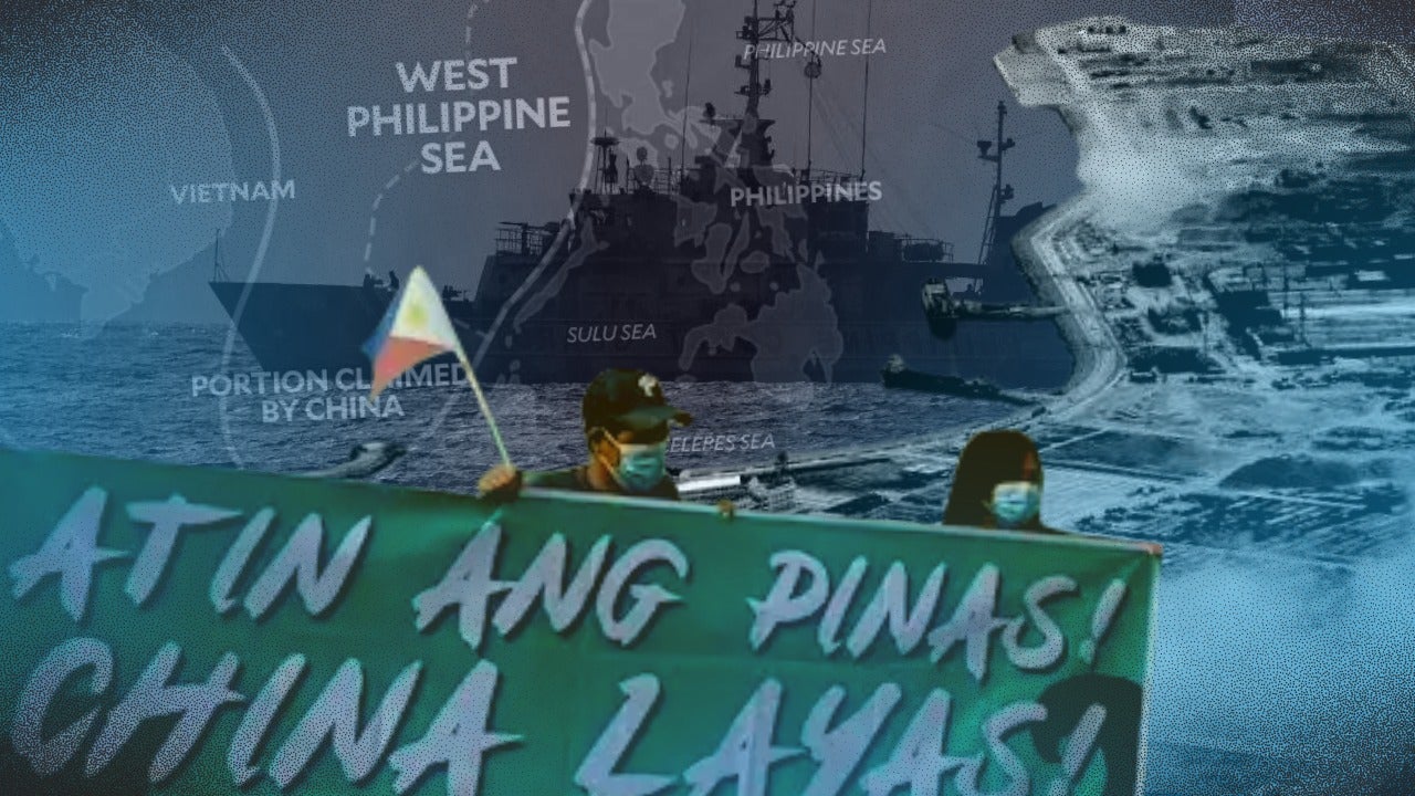
MANILA, Philippines—President Ferdinand “Bongbong” Marcos Jr. was not exaggerating when he said very recently that China’s reclamation inside Philippine exclusive economic zone (EEZ) was getting closer and closer to shore.
But there appears to be no end to China’s baseless assertion of having exclusive rights over 85.7 percent of the South China Sea (SCS) even as tension caused by China’s aggression in the area “has become more dire than ever before.”
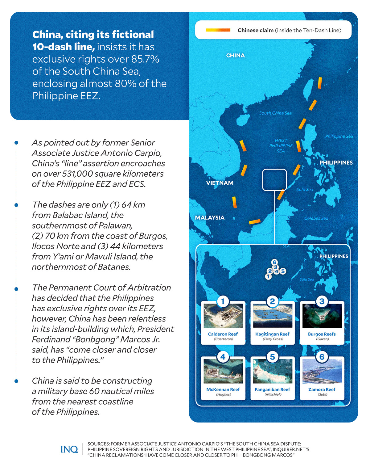
The Chinese aggression continued in spite of the 2016 decision of the Permanent Court of Arbitration that declared China’s nine-dash line (now 10-dash) to be based on fictitious claims. The dashes, which have become 10 this year, enclose over three million square kilometers.
READ: China’s new ‘10-dash line’ map incorporates Taiwan, most of West PH Sea
According to a book by former Supreme Court Senior Associate Justice Antonio Carpio, the dashes cover 80 percent of the exclusive economic zone (EEZ) of the Philippines, comprising 381,000 square kilometers of maritime space.
Article continues after this advertisementThe dashes are only 64 kilometers from Balabac Island, the southernmost of Palawan; 70 kilometers from the coast of Burgos, Ilocos Norte; and 44 kilometers from Y’ami or Mavuli Island, the northernmost part of Batanes.
Article continues after this advertisementThrough its “illegal” invention, China, almost 40 years ago, started construction on reefs within the WPS, but this year, Marcos revealed that China’s reclamation has come “closer and closer” to Philippine shores.
READ: China reclamations ‘have come closer and closer to PH’ – Bongbong Marcos
He said that the closest one, which is seen to become a military base for the People’s Liberation Army, is only 60 nautical miles, or 111.12 kilometers, from the country’s coastline.
Looking back, it was in 2021 when Filipinos expressed concern over reports that soil from the Philippines is being used by China for its island-building frenzy in WPS.
Almost 10 years ago, the governor of Zambales province in the Philippines said soil and sand from mountains “leveled” by mining could have been used by China, too, with Filipino fishermen seeing the soil and sand being used to reclaim reefs in the WPS.
Same old tactic
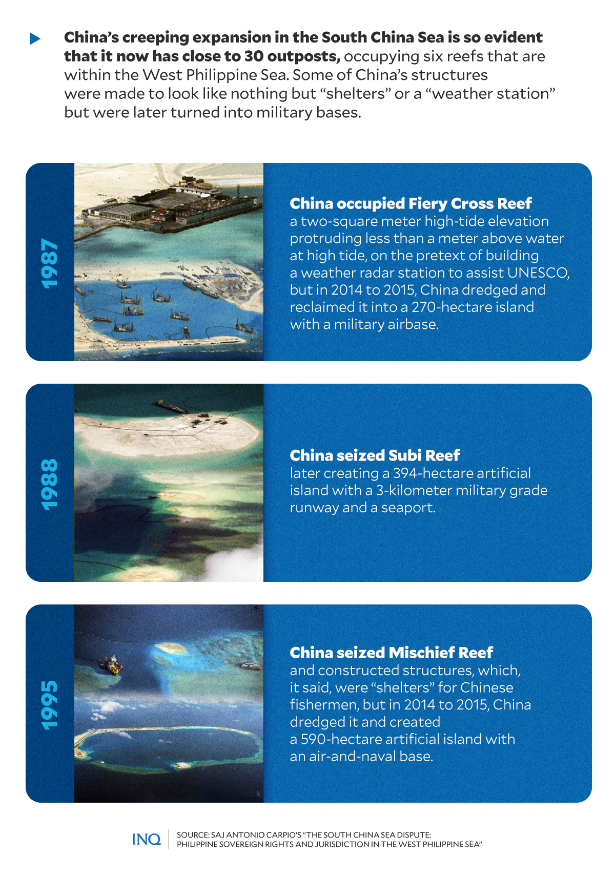
China’s extensive expansion in the SCS is so evident in plain sight that it now has close to 30 outposts, according to data from Asia Maritime Transparency Initiative (AMTI), occupying six reefs that are within the WPS. AMTI is a watchdog keeping tabs on developments in SCS using satellite technology among other means.
READ: DFA ‘seriously concerned’ over China’s ‘reclamation activities’ in Spratly’s unoccupied reefs
But most of China’s structures, especially those within the EEZ of the Philippines, before becoming high-grade military bases, were made to look like nothing but “shelters” or a “weather station.”
As stated in Carpio’s book, “The South China Sea Dispute: Philippine Sovereign Rights and Jurisdiction in the West Philippine Sea,” it was in 1987 when China occupied the Fiery Cross Reef, a two-square meter high-tide elevation.
China, back then, said it was for the construction of a weather station to assist the United Nations Educational, Scientific and Cultural Organization in its global oceanic survey.
However, in 2014 to 2015, China dredged it and reclaimed the reef, turning it into a 270-hectare island military airbase with a 3-kilometer military grade runway and a seaport.
China seized Subi Reef from the Philippines in 1988, too, later creating a 394-hectare artificial island with a three-kilometer military grade runway and a seaport. Subi Reef is part of the territorial sea of Pagasa Island in the Spratlys.
Then in 1995, China took Mischief Reef and constructed structures, which, it said, were “shelters” for Chinese fishermen. However, in 2014 to 2015, China dredged it and created a 590-hectare artificial island with an air-and-naval base.
RELATED STORY: Chinese militia ships swarm Julian Felipe Reef in West Philippine Sea
Mischief Reef, located 125 nautical miles from Palawan, is a low-tide elevation within the Philippine EEZ. As part of its continental shelf, the Philippines is the only country with the right to exploit the natural resources in or erect structures on the reef.
Militarizing the sea
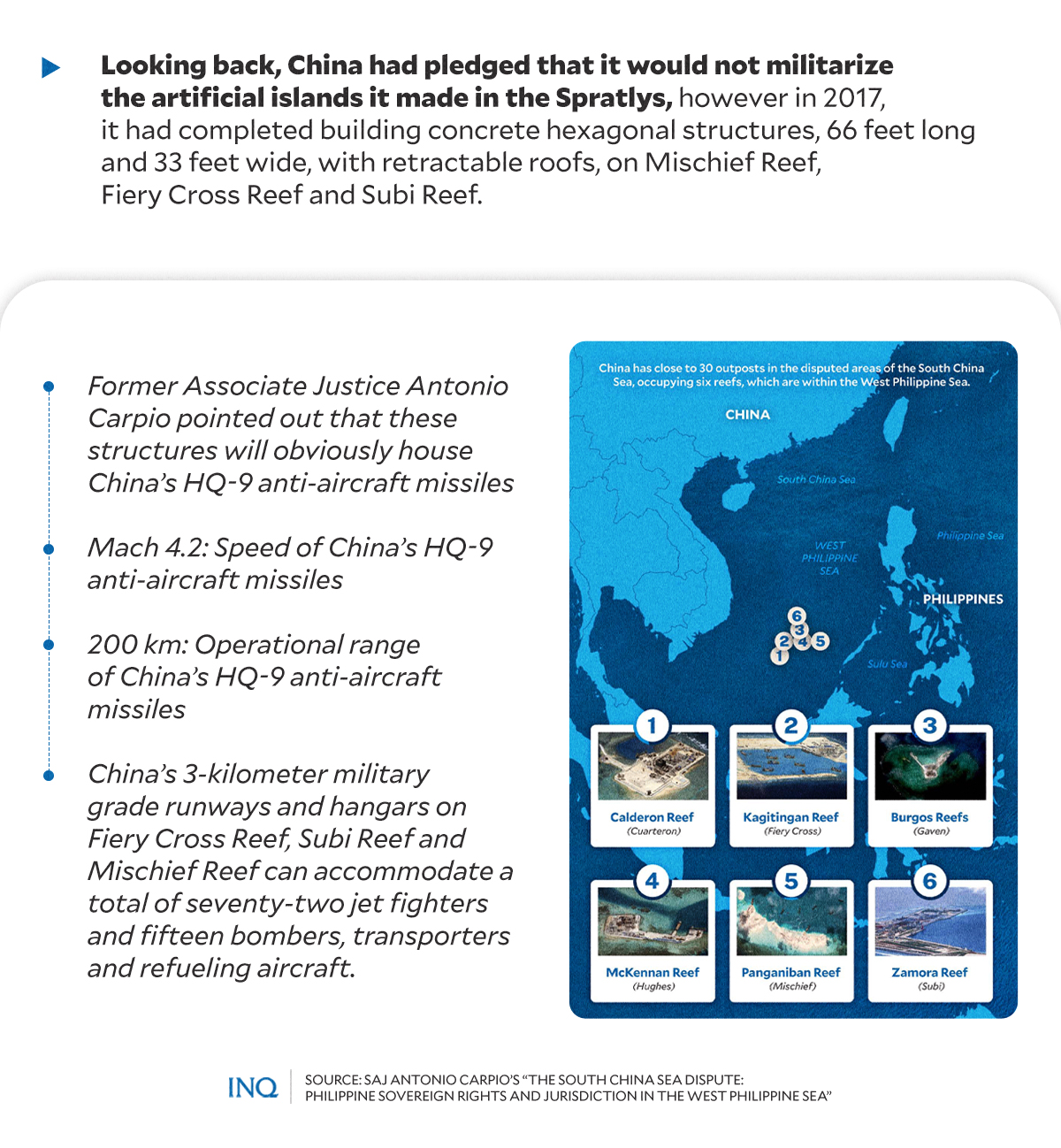
Carpio pointed out that the “creeping, eastward expansion” of China’s military outposts toward the nine-dash line will allow China to enforce the nine-dash line as its national boundary in the SCS.
As of 2017, China had already completed building concrete hexagonal structures, 66 feet long and 33 feet wide, with retractable roofs, on Mischief Reef, Fiery Cross Reef and Subi Reef in the Spratlys.
These structures, Carpio said, will obviously house China’s HQ-9 anti-aircraft missiles that have a speed of Mach 4.2 and an operational range of 200 kilometers.
“China can now declare and impose an Air Defense Identification Zone (ADIZ) in the SCS, with only the northeastern part of the SCS not covered by the radar of its anti-aircraft missile system,” he stressed.
However, an air and naval base in Scarborough Shoal, which is also controlled by China, will complete its radar coverage in the entire South China Sea, backed by anti-aircraft missile batteries covering a radius of 200 kilometers.
Likewise, China’s 3-kilometer military grade runways and concrete hangars on Fiery Cross Reef, Subi Reef and Mischief Reef can accommodate a total of 72 jet fighters and 15 bombers, transporters and refueling aircraft.
This, Carpio said, is far from what Chinese President Xi Jinping committed in 2015—that China will not militarize the artificial islands it built in the Spratlys.
“China’s grand design is to control the SCS for economic and military purposes,” Carpio said.
RELATED STORY: DFA to China: Remove illegal structures, cease reclamations