‘Potentially catastrophic’ Hurricane Otis heads for Mexico
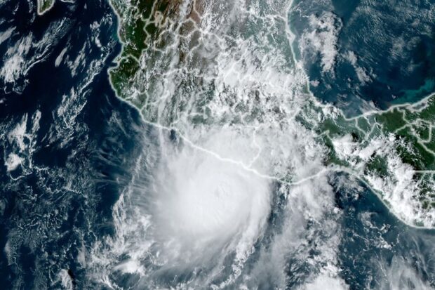
This handout picture courtesy of NOAA/RAAMB (National Oceanic and Atmospheric Administration / Regional and Mesoscale Meteorology Branch) taken on October 24, 2023 shows hurricane Otis approaching Mexico’s southern Pacific coast. Hurricane Otis on october 24, 2023 strengthened to a major Category 3 storm as it headed toward Mexico’s southern Pacific coast, the US National Hurricane Center (NHC) said. (Photo by NOAA / AFP)
Acapulco, Mexico — Hurricane Otis on Tuesday strengthened to a powerful Category 4 storm as it barreled toward Mexico’s Pacific coast, the US National Hurricane Center said, warning it could be “potentially catastrophic” upon landfall early Wednesday.
With the hurricane expected to continue to strengthen, “Otis is forecast to be a potentially catastrophic Category 5 hurricane when the center reaches the coast,” the NHC said, though it added that “rapid weakening will occur after landfall.”
Maximum sustained winds had increased to near 145 miles (230 kilometers) per hour, according to the NHC, which put Otis in the second-highest category on the five-step Saffir-Simpson scale.
As of Tuesday evening, the storm’s center was located about 85 miles from the beach resort city of Acapulco, and a hurricane warning was in effect for the coastline from Punta Maldonado to Zihuatanejo.
Authorities in the southern state of Guerrero suspended school classes and prepared to open emergency shelters.
Article continues after this advertisementSoldiers were seen patrolling the beach of Acapulco, where visitors made the most of the calm before the storm.
Article continues after this advertisement“We won’t be running any tours today,” boat operator Carolina Torres said, voicing hope that Otis might weaken before making landfall.
“If it hits us, that’s very serious for us,” she added.
Rainfall of up to 15 inches (38 centimeters) was expected across Guerrero and parts of neighboring Oaxaca state, the NHC said.
“This rainfall will produce flash and urban flooding, along with mudslides in areas of higher terrain,” it warned.
“A potentially catastrophic storm surge is expected to produce life-threatening coastal flooding,” it added.
Hurricanes hit Mexico every year on both its Pacific and Atlantic coasts, usually between May and November, though few make landfall as a Category 5.
READ: ‘Erratic’ Hurricane Norma on track to hit Mexico’s Baja California
Earlier this week, Tropical Storm Norma left three people dead, including a child, after making landfall for a second time in the northwestern state of Sinaloa.
Norma came ashore for the first time on the Baja California peninsula on Saturday before heading back out to sea, later barreling into the mainland.
Earlier this month, two people died when Hurricane Lidia, an “extremely dangerous” Category 4 storm, struck the western states of Jalisco and Nayarit.
And in August, storm Hilary, which at one point was also a Category 4 hurricane, caused one death and damaged infrastructure as it hit Baja California.
Scientists have warned that storms are becoming more powerful as the world gets warmer with climate change.