Jenny to bring rains to Luzon, Signal No. 3 up in Batanes, says Pagasa
MANILA, Philippines — Typhoon Jenny’s center remains distant from the Philippine landmass, but its impact persists on Luzon and whips up the southwest monsoon.
This is based on the 11 a.m. forecast on Wednesday of the Philippine Atmospheric, Geophysical and Astronomical Services Administration (Pagasa).
According to Pagasa, the clouds brought by the typhoon are bringing rain to Northern Luzon.
The typhoon itself enhances the southwest monsoon – which is causing downpours in western parts of Central and Southern Luzon.
“Dalawa po yung hihimayin natin: Yung weather na dulot ng bagyong si Jenny sa Northern Luzon area, at yung mga paulan ng habagat sa ilang bahagi ng Central at Southern Luzon,” Pagasa Assistant Weather Services Chief Chris Perez said.
(We will discuss two things: The weather brought by typhoon Jenny in Northern Luzon and the rains from the southwest monsoon in some portions of Central and Southern Luzon.)
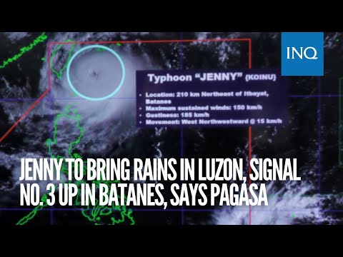
Typhoon Jenny has maximum sustained winds of 150 kilometers per hour near its center and gustiness of up to 185 kilometers per hour.
It is currently moving west-northwestward at 15 kilometers per hour.
At 10:00 a.m., the typhoon was last seen 210 kilometers northeast of Itbayat, Batanes.
Tropical Cyclone Wind Signal (TCWS) No. 3 was raised in the area.
The rest of Batanes and the northern portion of Babuyan Islands, particularly Babuyan Island and Calayan Island, are under TCWS No. 2
Areas under TWCS No. 2 will experience bad weather, with winds that can damage houses of light materials, electric posts, communication lines, and plants.
The rains might cause floods in low-lying areas.
Gale warnings are raised in these areas, as well as in Isabela and Ilocos Norte.
Meanwhile, the following areas have been placed under TCWS No. 1:
Rest of the Babuyan Islands
The northern portion of mainland Cagayan (Santa Ana, Gonzaga, Buguey, Santa Teresita, Lal-Lo, Camalaniugan, Pamplona, Claveria, Aparri, Ballesteros, Abulug, Allacapan, Sanchez-Mira, Santa Praxedes, Lasam, Gattaran)
Northern portion of Apayao (Calanasan, Pudtol, Luna, Santa Marcela, Flora)
Northern portion of Ilocos Norte (Piddig, Bangui, Vintar, Burgos, Pagudpud, Bacarra, Adams, Pasuquin, Carasi, Dumalneg, Laoag City)
These areas may experience rains and occasional gustiness of winds.
On the other hand, as the typhoon intensifies the southwest monsoon, rains are expected in parts of Central and Southern Luzon.
“At dahil sa location at pagkilos ng bagyong si Jenny, patuloy nitong pinag-iibayo ang habagat,” Perez reported.
(Due to the location and movement of the typhoon, it continues to intensify the southwest monsoon.)
“So, dito nga sa may bandang kanluran ng gitna at katimugang Luzon, may inaasahan din tayong paulan,” he said.
(So here in the western area of Central and Southern Luzon, we are expecting rains.)
The weather bureau reminded people experiencing typhoons and areas affected by southwest monsoon about possible flooding and landslides.
RELATED STORIES
Typhoon Jenny’s Signal No. 3 a possibility, says Pagasa
Typhoon Jenny slows down, slightly weakens – Pagasa