Goring now a severe tropical storm, may become typhoon by Saturday — Pagasa
MANILA, Philippines — Severe Tropical Storm Goring continues to intensify as it moves southeast, the Philippine Atmospheric, Geophysical and Astronomical Services Administration (Pagasa) said on Friday afternoon.
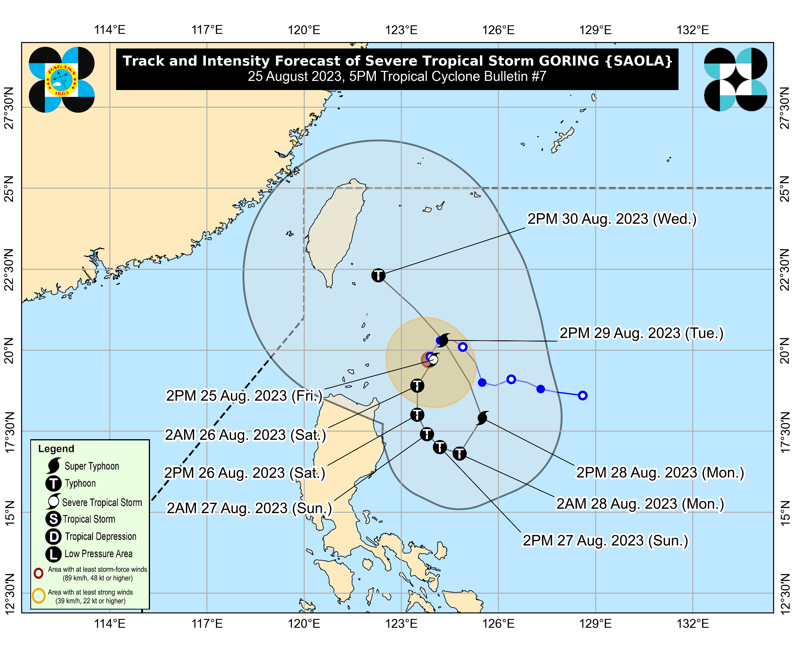
Pagasa’s latest bulletin showed that Goring now packs maximum sustained winds of 110 kilometers per hour (kph) near the center and gustiness of up to 135 kph.
As of 4:00 p.m., it was last seen 260 kilometers east of Calayan, Cagayan, and was moving slowly in a southeastward direction.
According to Pagasa, due to Goring spending more time over warm waters, the cyclone is expected to undergo rapid intensification, reaching typhoon-category strength by Saturday — before attaining its maximum strength by Monday.
Pagasa maintains that it has the potential to become a super typhoon. If it does, Goring will be the third super typhoon to enter the Philippine area of responsibility, after Super Typhoon Betty and Super Typhoon Egay.
Article continues after this advertisement“Goring is forecast to rapidly intensify and may reach typhoon category by tomorrow. Goring is forecast to steadily strengthen and may attain its maximum strength by Monday, potentially becoming a Super Typhoon,” Pagasa said.
Article continues after this advertisement“Considering these developments, the public and disaster risk reduction and management offices concerned are advised to take all necessary measures to protect life and property. Persons living in areas identified to be highly or very highly susceptible to these hazards are advised to follow evacuation and other instructions from local officials,” it added.
As of now, Tropical Cyclone Wind Signal No. 1 is raised over the following areas:
- Batanes
- Eastern portion of Babuyan Islands (Babuyan Islands, Camiguin Islands)
- Eastern portion of mainland Cagayan (Santa Ana, Gonzaga, Lal-Lo, Gattaran, Baggao, Peñablanca, Santa Teresita, Buguey, Camalaniugan, Aparri)
- Eastern portion of Isabela (Maconacon, Divilacan, Palanan, Dinapigue, San Mariano, San Pablo, Cabagan, Tumauini, Ilagan City)
Pagasa expects Goring to continue moving south until Sunday and then start moving eastward.
It would then complete a circular motion on Tuesday, back near its original position today, as a super typhoon. After which, Goring would move northwest towards Taiwan, but it would slightly weaken into a typhoon-category cyclone.
Pagasa is not yet expecting a landfall scenario but state meteorologists’ cone of probability includes the northern portions of Cagayan and Batanes if Goring steers closer to the west.
While it may not hit land, Goring is expected to enhance the southwest monsoon or habagat, causing rains and strong winds over areas under the wind signals and the following regions and provinces:
- Saturday: Aurora, Bataan, Metro Manila, Calabarzon, Bicol Region, Dinagat Islands, and most of Mimaropa, and Visayas
- Sunday: Aurora, Bataan, Metro Manila, Calabarzon, Mimaropa, Bicol Region, Visayas, Dinagat Islands, and Surigao del Norte
READ: Super Typhoon Egay: Half a million affected, billions in damage in Northern Luzon