Signal no. 1 up in northeastern Cagayan due to Goring — Pagasa
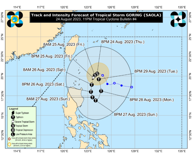
Tropical storm Goring’s latest track and intensity forecast. (Photo courtesy of Pagasa)
MANILA, Philippines — Tropical Cyclone Wind Signal No. 1 was raised in the northeastern of Cagayan due to tropical storm Goring (international name: Saola), said the Philippine Atmospheric, Geophysical and Astronomical Services Administration (Pagasa) on Thursday evening.
Pagasa, in its bulletin issued at 11 p.m., said dwellers in the northeastern portion of mainland Cagayan may experience strong winds within the next 36 hours.
“Minimal to minor impacts from strong winds are also possible within any of the areas where wind signal no. 1 is hoisted,” said Pagasa.
Goring, according to the state weather bureau, was last spotted 235 kilometers (km) east of Basco, Batanes with maximum sustained winds of 65 kilometers per hour (kph) and gustiness of up to 80 kph.
It is slowly moving westward.
Due to this weather disturbance, at least 50 to 100 millimeters of rainfall is expected in Batanes and Babuyan Islands beginning Thursday evening, August 24 until Friday evening, August 25.
At least 50 to 100 millimeters of rainfall is likewise expected in the eastern portion of mainland Cagayan beginning Friday until Saturday evening, August 26.
“Forecast rainfall [is] generally higher in elevated or mountainous areas. Under these conditions, flooding and rain-induced landslides are possible especially in areas that are highly or very highly susceptible to these hazards as identified in hazard maps and in localities that experienced considerable amounts of rainfall for the past several days,” Pagasa noted.
Pagasa said due to the highly favorable environment, Goring is forecast to rapidly intensify and may reach typhoon category by Saturday morning.
It may reach its peak intensity on Sunday evening, August 27. However, the chances of it developing into a super typhoon is not yet ruled out by the state weather bureau.
This weather disturbance is also likely to enhance the southwest monsoon, locally known as “habagat.”
The cyclone-enhanced monsoon will trigger intermittent rain over the western portions of Central and Southern Luzon beginning Friday and over the western portion of Visayas starting Saturday.
It may also cause gusty conditions over the following areas starting Saturday:
- Aurora
- Bataan
- Metro Manila
- Calabarzon
- Bicol Region
- Dinagat Islands
- most of MIMAROPA and Visayas
- Dinagat Islands
- Surigao del Norte