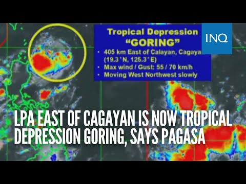
MANILA, Philippines — The low pressure area (LPA) east of Cagayan has intensified into a tropical depression and is now locally named Goring, the state weather bureau said Thursday.
Goring was located 405 kilometers east of Calayan, Cagayan, packing maximum wind speeds of 55 kilometers per hour (kph) and gustiness of up to 70 kph, according to the Philippine Atmospheric, Geophysical and Astronomical Services Administration (Pagasa).
Pagasa also said that Goring will have an irregular movement direction for the next five days, as it is expected to strengthen further into a typhoon.
“Magiging kakaiba ang pagkilos nitong si bagyong Goring, dahil magkakaroon tayo ng pag-ikot or looping track sa susunod na limang araw. So, ibig sabihin po for the next 12 hours kikilos pahilaga itong si Bagyong Goring then simula po bukas hanggang sa Lunes or over the long weekend, ay kikilos patimog in general si bagyong Goring at inaasahang lalakas pa ito into tropical storm by tomorrow, at typhoon category naman po pagsapit ng Lunes,” explained Pagasa weather specialist Benison Estareja.
(Cyclone Goring will behave differently, as we will have a rotating or looping track for the next five days. So, this means that for the next 12 hours, Typhoon Goring will move northward, then starting tomorrow until Monday or over the long weekend, typhoon Goring will generally move southward and it is expected to strengthen into a tropical storm by tomorrow, and typhoon category by Monday.)
READ: Pagasa: LPA spotted in east of Cagayan may develop into tropical cyclone
The state weather service said areas in Cagayan valley may experience heavy rainfall. It added that tropical cyclone wind signals may possibly be raised within today, August 24, or tomorrow, Friday, over northern Luzon areas such as Cagayan Valley and Cordillera Administrative Region.
In the coming days, Pagasa said hoisting tropical cyclone wind signals over Central Luzon, Ilocos Region, Calabarzon, and northern portion of Bicol Region is also possible.
“Considering the proximity of Goring to land, any westward shift in the track forecast may result in heavy rainfall over portions of Cagayan Valley in the next three days, and is less likely over the rest of the country,” Pagasa’s public report indicated.
Goring is forecast to stay inside the Philippine area of responsibility (PAR) for a week, and enhance the southwest monsoon, which is locally known as habagat.
“Nasa isang linggo pa mananatili ng PAR itong si Bagyong Goring at bukod sa epekto nito sa Cagayan Valley, ay mag-eenhance rin po ito ng habagat or southwest monsoon, over many areas of the country,” Estareja said.
(Tropical Depression Goring will remain under PAR for another week and apart from its impact on Cagayan Valley, it will also enhance the southwest monsoon over many areas of the country.)
The tropical depression-boosted southwest monsoon is anticipated to bring rain and gusty conditions in Luzon, Visayas, and northern Mindanao, according to Pagasa.
In the meantime, Pagasa said Metro Manila and other areas in northern Luzon will experience cloudy skies with chances of localized thunderstorms on Thursday.
READ: Pagasa: Cloudy Thursday with possible rain showers due to LPA off Cagayan, ‘habagat’
It likewise noted that another tropical cyclone was seen forming more than 2,900 km east of northern Luzon – outside PAR. But it has no direct effect yet on the country’s weather. Pagasa said it is not expecting the looming weather disturbance to enter PAR as of now.
As for the country’s seaboards, Pagasa said waves will be slight to moderate (0.6 to 2.1 meters) on Thursday and moderate to rough (1.5 to 2.5 meters) on Friday over extreme northern Luzon and northeastern portion of mainland Cagayan. The state weather bureau did not raise any gale warning as of morning of August 24.
