Super Typhoon Egay keeps strength; Signal No. 5 up on Babuyan’s Camiguin Island

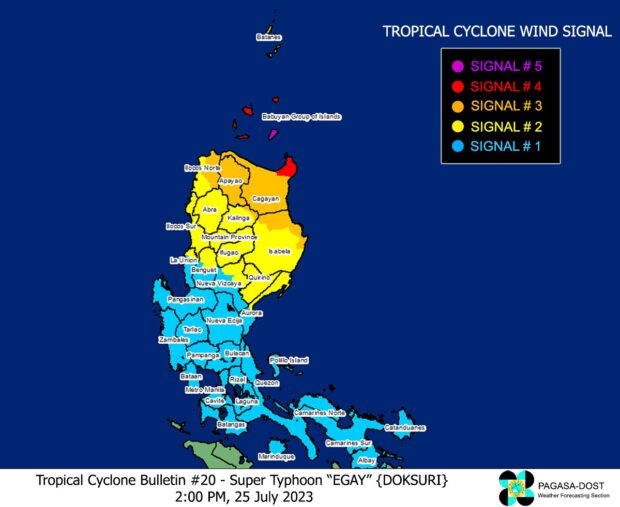
Due to Super Typhoon Egay (international name: Doksuri), tropical Cyclone Wind Signals. Photo from Pagasa’s website
MANILA, Philippines — Camiguin, one of the five big islands of Babuyan, was placed under Tropical Cyclone Wind Signal (TCWS) No. 5 on Tuesday afternoon as Super Typhoon Egay (international name: Doksuri) maintained its strength while crossing the Philippine Sea.
The Philippine Atmospheric, Geophysical and Astronomical Services Administration (Pagasa) said in its 2 p.m. cyclone update that Egay was moving northwestward at 20 kilometers per hour (kph) as it was last spotted 230 kilometers east-northeast Cagayan province’s Tuguegarao City.
Egay was packing maximum sustained winds of 180 kph and gustiness of up to 230 kph, according to state meteorologists.
READ: LIVE UPDATES: Super Typhoon Egay
Egay’s strong winds and rain also made Pagasa hoist TCWS No. 4 over the northeastern part of mainland Cagayan (Santa Ana and Gonzaga) and the rest of Babuyan Islands – Babuyan Island, Calayan Island, Fuga Island, and Dalupiri Island.
Article continues after this advertisementTCWS No. 3, on the other hand, remained over the following areas:
Article continues after this advertisement- The northeastern portion of Isabela (Divilacan, Maconacon, Palanan, Santa Maria, San Pablo, Santo Tomas, Cabagan, Tumauini)
- The rest of Cagayan, Apayao, the eastern portion of Ilocos Norte (Vintar, Adams, Pagudpud, Dumalneg, Nueva Era, Carasi, Bangui, Piddig, Solsona)
- The northeastern part of Kalinga (Rizal, Pinukpuk)
- Batanes
Meanwhile, TCWS No. 2 was raised over:
- The rest of Isabela, northern and central portions of Aurora (Dilasag, Casiguran, Dinalungan, Dipaculao)
- Quirino
- The rest of Kalinga
- The northeastern part of Nueva Vizcaya (Kasibu, Quezon, Diadi, Bagabag, Ambaguio, Villaverde, Solano, Bayombong)
- The rest of Ilocos Norte
- Ilocos Sur
- Abra
- Mountain Province
- Ifugao
- Northern portion of Benguet (Bakun, Mankayan, Buguias, Kabayan, Kibungan, Atok)
- The northern part of La Union (Bangar, Sudipen, Luna, Balaoan, Santol)
Pagasa likewise placed under TCWS No. 1 the following areas:
- Metro Manila
- Quezon, including Pollilo Islands
- The rest of Aurora
- The rest of Nueva Vizcaya
- The rest of Benguet
- The rest of La Union
- Nueva Ecija
- Pangasinan
- Tarlac
- Zambales
- Bulacan
- Pampanga
- Bataan
- Marinduque
- Cavite
- Rizal
- Laguna
- Batangas
- Camarines Norte
- Camarines Sur
- Albay
- Catanduanes
The state weather service said Egay is forecast to hit or pass very close to the Babuyan Islands-northeastern mainland Cagayan area today (July 25) or early morning Wednesday.
It added that the super typhoon is expected to exit the Philippine area of responsibility by Thursday morning and will make landfall in the vicinity of Fujian, China, on Friday morning.
RELATED STORIES
Parts of Cagayan under Signal No. 4 due to Super Typhoon Egay; winds up to 184 kph possible
11 regions feel impact of Egay