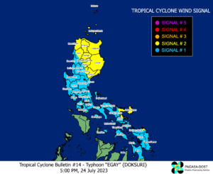
Signal No. 2 in 17 areas as Typhoon Egay intensifies — Pagasa

MANILA, Philippines — Seventeen areas are now under Tropical Cyclone Wind Signal (TCWS) Number 2 as Typhoon Egay (international name: Doksuri) steadily intensifies, the Philippine Atmospheric, Geophysical and Astronomical Services Administration (Pagasa) said in its 5:00 p.m. update.
Pagasa said the center of Egay, which was last spotted some 500 kilometers east of Baler, Aurora, has increased its maximum sustained winds from 150 kph near the center to 155 kph and gustiness from 185 kph to 190 kph while moving northwest at 10 kph.
TCWS No. 2 is up over the following areas:
Luzon
- Catanduanes
- eastern portion of Albay (Rapu-Rapu, Bacacay, City of Tabaco, Malilipot, Malinao, Tiwi)
- northern portion of Camarines Norte (Calaguas and Maculabo Islands)
- eastern portion of Camarines Sur (Caramoan, Presentacion, Garchitorena, Lagonoy, San Jose, Sagñay)
- Isabela
- northern and central parts of Aurora (Dilasag, Casiguran, Dinalungan, Dipaculao)
- Quirino
- Cagayan including Babuyan Islands
- Apayao
- Kalinga
- central and eastern parts of Mountain Province (Paracelis, Natonin, Barlig, Sadanga, Bontoc)
- eastern portion of Nueva Vizcaya (Kasibu, Quezon, Diadi, Bagabag)
- eastern portion of Ifugao (Alfonso Lista, Aguinaldo, Mayoyao, Lagawe, Banaue, Hingyon, Lamut)
- central and eastern parts of Abra (Tineg, Lacub, Malibcong, Lagangilang, San Juan, Dolores, Lagayan, Danglas, La Paz, Daguioman, Boliney, Bucloc, Licuan-Baay, Sallapadan, Tayum, Bucay, Bangued, Peñarrubia, Manabo, Tubo)
- Ilocos Norte
- Batanes
Visayas
- The northeastern portion of Northern Samar (Laoang, Palapag)
A 62 to 88 kph wind speed is expected in the said areas in the next 24 hours.
TCWS No. 1 is up over the the following areas:
Luzon
- Sorsogon
- Masbate including Ticao Island, Burias Island
- The rest of Albay
- The rest of Camarines Sur
- The rest of Camarines Norte
- The rest of Abra
- The rest of Mountain Province
- The rest of Ifugao
- The rest of Nueva Vizcaya
- Quezon including Pollilo Islands
- The rest of Aurora
- Benguet
- Ilocos Sur
- La Union
- Pangasinan
- Nueva Ecija
- Tarlac
- Zambales
- Bataan
- Bulacan
- Pampanga
- Metro Manila
- Rizal
- Cavite
- Laguna
- Marinduque
- central and eastern portions of Romblon (Banton, Corcuera, Romblon, Magdiwang, Cajidiocan, San Fernando)
- The northern and central portions of Batangas (Calaca, Cuenca, Taysan, Lian, Tuy, Balayan, Talisay, Padre Garcia, Agoncillo, Santo Tomas, San Jose, Lemery, Lipa City, Ibaan, City of Tanauan, Mataasnakahoy, Alitagtag, Balete, Nasugbu, San Juan, San Nicolas, Rosario, Laurel, Santa Teresita, Taal, Malvar)
Visayas
- Eastern Samar
- The rest of Northern Samar
- Samar
- Biliran
- The northern and central portions of Leyte (Tunga, Pastrana, San Miguel, Mahaplag, Matag-Ob, Tolosa, Palo, Calubian, Leyte, Mayorga, Julita, Carigara, Babatngon, Dagami, Jaro, Abuyog, San Isidro, Santa Fe, Albuera, Villaba, La Paz, Palompon, Macarthur, Tabontabon, Tanauan, Merida, Ormoc City, Isabel, Javier, Dulag, Capoocan, Alangalang, City of Baybay, Burauen, Tabango, Tacloban City, Kananga, Barugo)
- The northern portion of Cebu (Daanbantayan, Medellin) including Bantayan Islands, Camotes Islands
Intermittent rainfall and 39-61 kph winds are expected within 36 hours: