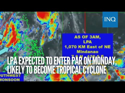
MANILA, Philippines — The low-pressure area (LPA) monitored east of northeast Mindanao would likely enter the Philippine area of Responsibility (PAR) within the day and is forecast to develop into a tropical cyclone in one to two days, the state weather bureau said on Monday.
Citing its 5 a.m. bulletin, Philippine Atmospheric, Geophysical and Astronomical Services Administration (Pagasa) said the LPA outside PAR was last spotted 1,070 kilometers east of northeast Mindanao.
“Itong LPA nating ito base sa ating huling datos ay posibleng maging bagyo sa isa hanggang dalawang araw at posibleng ngayong Lunes ay pumasok na ito ng PAR,” weather forecaster Obet Badrina said in a morning forecast.
(According to our latest data, this LPA may become a typhoon in one to two days, and it may enter the PAR this Monday.)
“Wala pa naman itong direktang epekto sa anumang bahagi ng ating bansa at base sa ating datos posible itong kumilos papalapit sa ating bansa kung maging bagyo man. Ito kasing track ng mga bagyo kapag July yung bahagi ng Luzon o kaya minsan ito ay nagrerecruve sa bahagi ng Japan,” he added
(It does not directly impact any part of our country, but based on our latest findings, it may either move closer to our country or recurve to Japan since this is usually the track of tropical cyclones every July.)
Meanwhile, Badrina said that tropical storm Dodong (international name Talim) is on its way to Hainan Island or the southern part of China. It was last spotted 825 kilometers west of extreme Northern Luzon.
On the other hand, Badrina said that the southwest monsoon, or “habagat,” will continue to bring overcast skies and rain showers across the country.
Due to the effects of habagat, he said that a gale warning remained raised in Batanes, Babuyan Islands, Romblon, Marinduque, Ilocos Norte, Ilocos Sur, La Union, Pangasinan, Zambales, Bataan, the western coast of Batangas, Occidental Mindoro, including Lubang Island, Palawan, including Calamian, Cagayancillo, Cuyo, Kalayaan Islands and the southern coast of Quezon.
In the meantime, below is the forecast temperature range in key cities or areas for Monday, according to Pagasa:
- Metro Manila: 25 to 31 degrees Celsius
- Baguio City: 17 to 20 degrees Celsius
- Laoag City: 26 to 32 degrees Celsius
- Tuguegarao: 26 to 32 degrees Celsius
- Legazpi City: 25 to 32 degrees Celsius
- Puerto Princesa City: 25 to 31 degrees Celsius
- Tagaytay: 22 to 28 degrees Celsius
- Kalayaan Islands: 25 to 31 degrees Celsius
- Iloilo City: 26 to 31 degrees Celsius
- Cebu: 25 to 32 degrees Celsius
- Tacloban City: 26 to 33 degrees Celsius
- Cagayan De Oro City: 24 to 32 degrees Celsius
- Zamboanga City: 25 to 32 degrees Celsius
- Davao City: 26 to 32 degrees Celsius
