
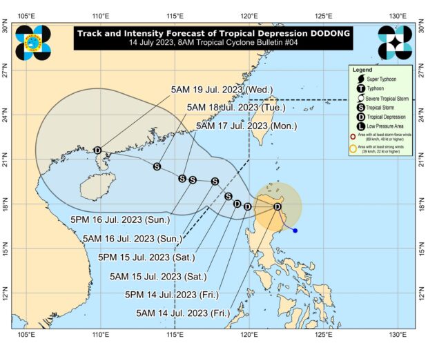
Tropical Depression Dodong’s track. Photo from Pagasa’s website
MANILA, Philippines — Tropical Depression Dodong was able to maintain its strength as it continues to move away from the country’s landmass, the Philippine Atmospheric, Geophysical and Astronomical Services Administration (Pagasa) said on Friday evening.
Updates from Pagasa showed that the center of Dodong, as of 10 p.m., was spotted 160 kilometers northwest of Dagupan City, Pangasinan. It still packs maximum sustained winds of 55 kilometers per hour (kph), and gustiness of up to 70 kph.
It is now moving southwest, at a speed of 15 kph.
According to Pagasa, the cyclone’s prolonged stay over bodies of water may translate to it gaining strength, intensifying into a tropical storm before it exits the Philippine area of responsibility (PAR) — and a severe tropical storm once it leaves.
The latest track shows that on Saturday morning, Dodong would possibly be located 125 kilometers west southwest of Sinait, Ilocos Sur, as a tropical storm. It would then start a northwest movement, exiting the PAR between Saturday night and early Sunday morning.
By Monday morning, it would be located 710 kilometers west of Calayan, Cagayan. or south of mainland China. During this time, it would intensify further as a severe tropical storm.
All tropical cyclone wind signals have been lifted, except for Ilocos Norte and Ilocos Sur, which are under Signal No. 1. Still, Pagasa warned that a huge portion of Luzon would experience rains — particularly La Union and Pangasinan— as Dodong would intensify the southwest monsoon or habagat.
“Under these conditions, flooding and rain-induced landslides are possible, especially in areas that are highly or very highly susceptible to these hazard(s) as identified in hazard maps and in localities that experienced considerable amounts of rainfall for the past several days,” Pagasa said.
Pagasa also identified areas that may be affected by gusty conditions in the coming days due to the southwest monsoon:
- Friday night to Saturday: Areas in Ilocos Region not under any wind signal, Cordillera Administrative Region, Batanes, Isabela, Quirino, Nueva Vizcaya, Central Luzon, Metro Manila, Calabarzon, Mimaropa, Bicol Region, and Western Visayas
- Sunday: Ilocos Region, Zambales, Bataan, Cavite, Mimaropa, Bicol Region, Western Visayas, and the southern portion of Quezon
- Monday: Ilocos Region, Zambales, Bataan, Cavite, Oriental Mindoro, Palawan, Romblon, and Antique
“In the next 24 hours, Dodong and the enhanced Southwest Monsoon may bring moderate to rough seas over the eastern (1.5 to 3.0 m) and western (2.0 to 4.0 m) seaboards of Northern Luzon, and the western seaboards of Central and Southern Luzon (2.0 to 4.0 m),” Pagasa said.
“Mariners of small seacrafts are advised to take precautionary measures when venturing out to sea. If inexperienced or operating ill-equipped vessels, avoid navigating in these conditions,” it added.
RELATED STORIES:
LPA is now Tropical Depression Dodong; 16 areas under Signal No. 1 – Pagasa
Dodong may reach tropical storm category as it exits PH, says Pagasa