Pagasa: Storm Chedeng maintains strength, may intensify into typhoon
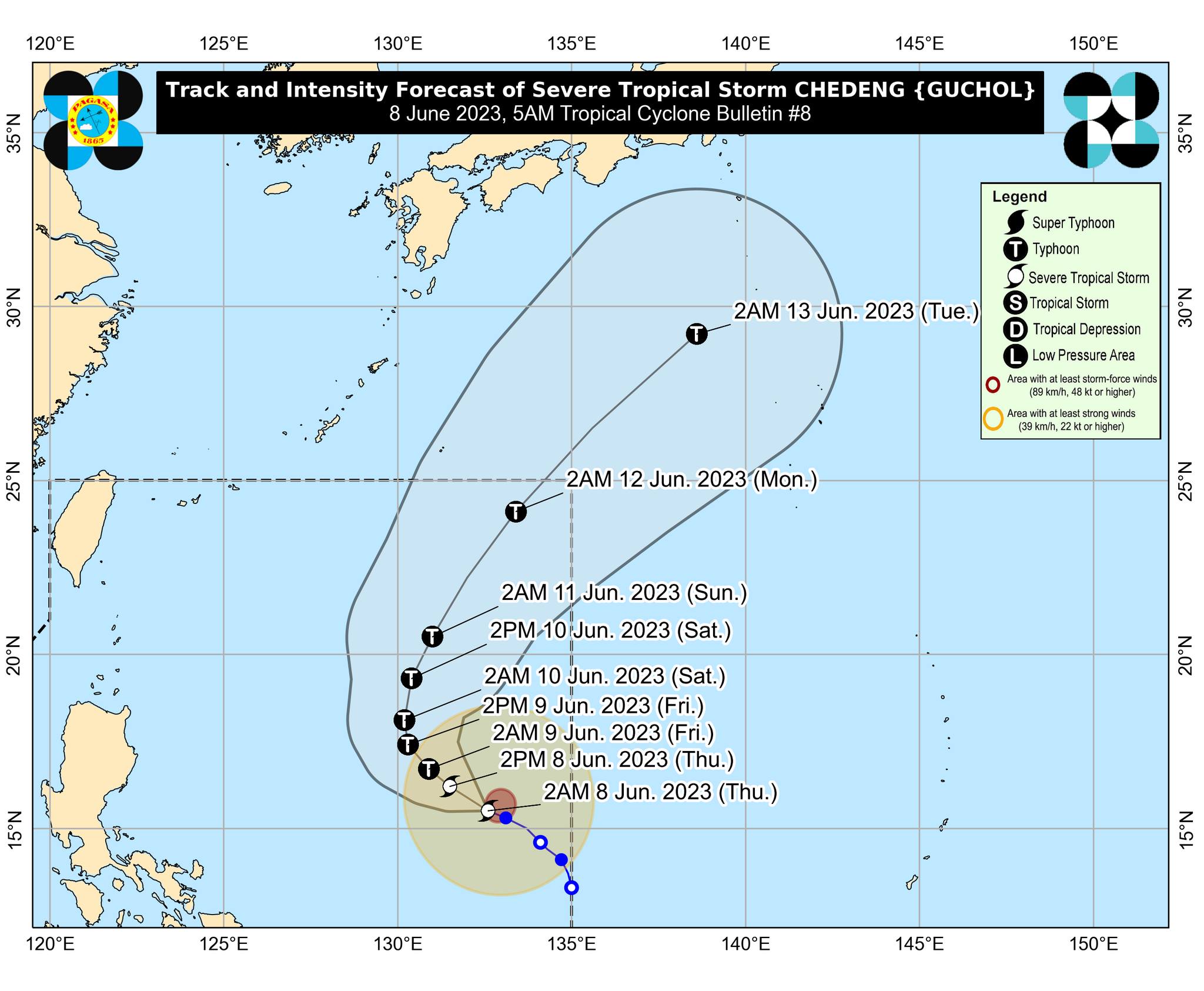
MANILA, Philippines — Severe tropical storm Chedeng (International name: Guchol) has maintained its strength over the Philippine Sea east of Central Luzon and may intensify into a typhoon by Friday, the Philippine Atmospheric, Geophysical and Astronomical Services Administration (Pagasa) said Thursday morning.
Pagasa weather specialist Benison Estareja said Chedeng was last monitored some 1,190 kilometers (km) east of Central Luzon with maximum sustained winds of 95 kilometers per hour (kph) and gustiness of up to 115 kph.
“Hindi rin direktang nakakaapekto itong kabuoan nitong si bagyong Chedeng sa malaking bahagi po ng ating bansa. Mabagal pa rin itong kumikilos, 10 kph lamang sa direksyong north northwest,” Estareja said in an early morning weather forecast.
(Typhoon Chedeng is not directly affecting most parts of our country and is still moving north-northwest slowly at 10 kph.)
“Posibleng lumakas ito bilang typhoon by tomorrow early morning. Pagsapit naman po ng weekend Sabado hanggang Linggo inaasahan na kikilos pahilaga at hilagang silangan itong si bagyong Chedeng habang nanatiling malakas as a typhoon,” he added.
(Chedeng may intensify into a typhoon by early tomorrow morning. Chedeng is expected to move north or northeast from Saturday to Sunday while remaining strong as a typhoon.)
Article continues after this advertisementEstareja added that Chedeng will remain distant from Philippine landmass, and there is a minimal chance that Pagasa will raise tropical cyclone wind signals over any part of the country.
Article continues after this advertisement“Habagat” rain in the next few days
The typhoon is forecast to leave the Philippine area of responsibility by Monday morning.
It is still expected, however, to enhance the southwest monsoon or “habagat,” which will affect the western part of the country in the next few days.
Meanwhile, no gale warning was hoisted over any of the country’s seaboards.
Forecast temperature range in key cities / areas on Thursday
- Metro Manila: 25 to 33 degrees Celsius
- Baguio City: 17 to 24 degrees Celsius
- Laoag City: 25 to 33 degrees Celsius
- Tuguegarao: 26 to 35 degrees Celsius
- Legazpi City: 25 to 32 degrees Celsius
- Puerto Princesa City: 25 to 31 degrees Celsius
- Tagaytay: 22 to 30 degrees Celsius
- Kalayaan Islands: 26 to 31 degrees Celsius
- Iloilo City: 27 to 32 degrees Celsius
- Cebu: 26 to 31 degrees Celsius
- Tacloban City: 26 to 32 degrees Celsius
- Cagayan De Oro City: 25 to 32 degrees Celsius
- Zamboanga City: 25 to 33 degrees Celsius
- Davao City: 25 to 33 degrees Celsius