Baguio, Benguet towns link up to protect Kennon watershed
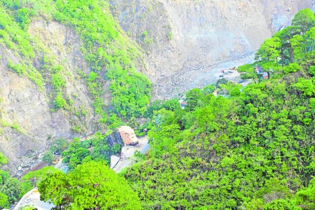
SCENIC ZIGZAG | Kennon Road, the popular “zigzag road” to Baguio City, is within the Bued River basin that flows from its headwaters in the Cordillera and cascades down to farmlands
in Pangasinan and La Union provinces. Baguio and its neighboring towns of Tuba and Itogon in Benguet are joining hands to preserve the river system and its watershed. (Photo by NEIL CLARK ONGCHANGCO / Inquirer Northern Luzon)
BAGUIO CITY, Benguet, Philippines — The conversion of Cordillera forests into farms, with an annual rate of 8.64 hectares of lost timberland, will impact 13 major river systems in Luzon, a group of researchers revealed on Tuesday.
This prompted this city and its neighboring Benguet towns of Tuba and Itogon to join hands and preserve the watershed of Kennon Road’s Bued River system using new data and a management plan drawn up by Project Danum, a multidisciplinary study group of the University of the Cordilleras that was funded by the Department of Science and Technology (DOST).
The 18,473.81-ha Bued River Basin leads down to the farmlands in the provinces La Union and Pangasinan. The headwaters of Bued and other river systems flowing into Luzon provinces are in the Cordillera, which has been described as Luzon’s watershed cradle.
Project Danum (the term is Ilocano for water) tracked the behavior of Bued River, particularly near the settlements along Kennon Road, and has been measuring the water and soil quality, moisture and temperature there, said project leader Nathaniel Vincent Lubrica, an engineer. It has also been calculating the potential impact of increased rainfall along the river system in the future.
The data collected helped shape the Bued watershed management plan that was turned over to the environment offices of Baguio, Tuba and Itogon on Tuesday.
Synchronized use
One of the plan’s recommendations was for all three local governments to synchronize and harmonize their respective land use plans.
Taking note of Baguio’s industrial and commercial land use priorities and Itogon’s dominant mineral extraction zones, Lubrica said most sections of Bued watershed must be reserved for forest use.
Itogon hosts some of the country’s oldest mining companies, which continue to operate today.
Tuba’s current land use for Bued is predominantly “strict forest protection,” followed by agriculture and a push for its own industrialization.
These communities must talk because “some of the proposed land use upstream may affect the land use downstream,” Lubrica said.
Project Danum also reviewed the rate of forest losses in the Bued area for the past 20 years, which confirmed that “when the urban area expanded and agricultural activities increased, the Bued forest decreased,” he said.
Lubrica heads another DOST-funded study group, Program Boondock, that is conducting several climate-impact research projects throughout the Cordillera.
At least 174,553 people live near or along the Bued River system and its watershed, according to Project Danum’s demographic profile of the area. They belong to 41 villages in Tuba, Itogon and Baguio. At least 70 percent of these Bued settlements are in the summer capital, he said.
Prone to landslides
Citing a 2021 socioeconomic study of Bued River that was conducted by the Department of Environment and Natural Resources, Project Danum said most of the dwellers were government or office workers, entrepreneurs and seasonal construction workers, with only 2 percent engaged in agriculture and 1 percent occasionally taking part in food production.
The Bued terrain is prone to landslides, which is a typical problem for the 34-kilometer Kennon Road, the shortest route to Baguio City from Pangasinan and La Union.
Lubrica said sections of its watershed have “inadequate vegetative cover” and “impermeable subsoil,” which may account for its “high drainage density.” This means runoff rainwater is not absorbed immediately by the ground, so it joins the Bued River channel and occasionally increases its water elevation as it flows to low-lying communities.
“We still have time to do something,” Lubrica said after water quality standards described the Bued River as being in “good condition.”
READ: