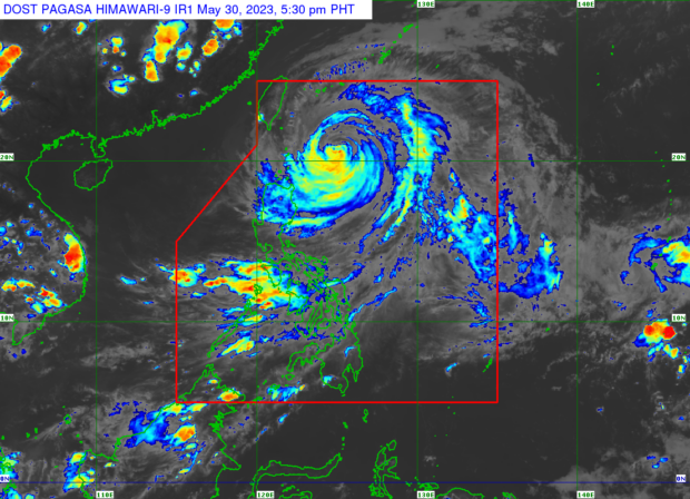
MANILA, Philippines — Typhoon Betty (international name: Mawar) is expected to exit the Philippine area of responsibility (PAR) by Thursday or Friday, the Philippine Atmospheric, Geophysical and Astronomical Services Administration (Pagasa) said Tuesday afternoon.
Until then, Tropical Cyclone Wind Signal (TCWS) No. 2 remains hoisted over Batanes, while TCWS No. 1 is up over Apayao, Cagayan, and Babuyan Islands, the northern and eastern parts of Isabela, eastern portion of Ilocos Norte, northern portion of Kalinga, and the northeastern portion of Abra.
“Inaasahan natin na aalis ng PAR si Betty ng Thursday o Friday, and then mula ngayon hanggang Thursday or Friday, yung habagat yung makakaapekto sa atin, lalo na sa Luzon,” said Pagasa weather forecaster Aldczar Aurelio.
(Betty is expected to exit PAR on Thursday or Friday, and then today until Thursday or Friday, the southwest monsoon will affect the weather, especially Luzon.)
Betty as of Tuesday afternoon was spotted some 315 kilometers east of Basco, Batanes, with maximum sustained winds of 150 kilometers per hour (kph) and gustiness of up to 185 kph., Pagasa reported.
Batanes can expect stormy conditions due to Betty, while the Babuyan Islands, Cagayan, Isabala, Apayao, Kalinga, Abra, and Ilocos Norte will have rains and gusty winds, added Pagasa.
The Mimaropa (Mindoro, Marinduque, Romblon, Palawan) region, Western Visayas, Zamboanga Peninsula, the rest of Ilocos region, Cordillera Administrative Region, and Cagayan valley will also experience cloudy skies with scattered rain due to the combined effects of Betty and the southwest monsoon.
The rest of the country could also expect rain due to the southwest monsoon.
Meanwhile, a gale warning is in effect over the northern seaboard of Northern Luzon, eastern seaboard of central Luzon, Southern Luzon, and the eastern seaboard of the Visayas due strong winds spawned by Betty.
