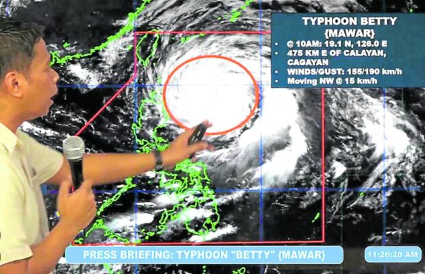
KEEPING TRACK | A state weather bureau forecaster briefs reporters on the track of Typhoon Betty on Monday morning, May 29, 2023. (DOST-PAGASA PHOTO)
TUGUEGARAO CITY, Cagayan, Philippines — At least 152 families, or 528 people, were evacuated in the provinces of Cagayan and Ilocos Norte since Sunday in anticipation of the impact of Typhoon Betty (international name: Mawar), authorities said on Monday.
The state weather bureau, however, said the typhoon had slightly weakened and is expected to further lose strength on its way out of the Philippine Area of Responsibility (PAR) through the Philippine Sea east of Northern Luzon.
Nevertheless, Cagayan was placed under “red alert” status, as local officials monitored weather updates and prepared contingency plans for disaster response.
According to the provincial disaster risk reduction and management office, most of the evacuated families were from coastal areas and low-lying communities vulnerable to landslides in the towns of Sta. Ana and Gonzaga and Calayan Island.
Although there was still no reported flooding in Gonzaga as of Monday, the municipal disaster risk reduction and management office began evacuation in that town, amid strong winds and occasional rains.
As of noon Monday, a total of 486 people from 140 families were taken to temporary shelters, with most of them living in the villages of Caroan, Ipil, Cabiraoan, and Sta. Clara in Gonzaga town.
Some 34 families or 111 people were evacuated from the villages of Poblacion, Dadao, Babuyan Claro, and Naguilan on Calayan Island.
The provincial boards of Cagayan and Isabela had earlier imposed a liquor ban in their respective areas starting Sunday.
Classes at all levels, both in public and private schools, were suspended on Monday in Cagayan.
Typhoon signals
The Philippine Atmospheric, Geophysical and Astronomical Services Administration (Pagasa) hoisted Signal No. 2 over parts of mainland Cagayan, the eastern part of Babuyan Islands (Babuyan Island, Camiguin Island, Didicas Island, Pamuktan Island), and the islands of Batanes province.
Areas in Northern Luzon placed under Signal No. 1 were the rest of the Babuyan Islands, the rest of mainland Cagayan, Isabela, Quirino, and parts of Nueva Vizcaya, Apayao, Abra, Kalinga, Mountain Province, Ifugao, and Ilocos Norte.
Also under Signal No. 1 were the northern and central parts of Aurora, Polillo Islands, the northern part of Catanduanes, the northeastern part of Camarines Sur, and the northern part of Camarines Norte.
In Ilocos Norte, 12 families, or 42 people, from Barangay Lanao in Bangui town were evacuated in anticipation of flooding and landslides, while classes from preschool to secondary levels in public and private schools were suspended in Batac City and Pasuquin town.
In Batangas province in Southern Luzon, sea travel among small vessels was suspended due to rough sea conditions, according to the Philippine Coast Guard (PCG).
The PCG also cited a forecast by Pagasa that a strong gale and rough to very rough sea conditions would be experienced in the seaboards of southern Luzon.
All trips by small seacraft with 250 gross tons or less, such as motorized passenger and fishing boats, were suspended.
Also suspended, in the Bicol region, were sea trips as well as classes in public and private schools.
‘No longer a supertyphoon’
But Esperanza Cayanan, the officer in charge of Pagasa, said Betty was “no longer [a] supertyphoon anymore, but of typhoon intensity and we see that it will continue to weaken.”
“It can weaken into 140 kilometers per hour (kph) wind intensity as it departs northwards. And before it leaves PAR, we see that it could be of storm intensity or simply a tropical storm with wind strength of 110 kph by Thursday night to Friday,” she said at Monday’s Laging Handa briefing.
Pagasa anticipates the storm to leave the country by Friday at the latest, not Thursday as earlier reported.
As of the state weather bureau’s bulletin Sunday afternoon, Betty packed maximum sustained winds of 165 kph, well below the supertyphoon level of 185 kph and above — the storm’s previous category early on Saturday when it entered PAR.
Pagasa’s bulletin by Monday afternoon said Betty was last spotted 445 km east of Calayan, Cagayan, packing maximum sustained winds of 155 kph near the center with gustiness of up to 190 kph.
Betty was still expected to enhance the southwest monsoon. But Cayanan said this would “not [be] that strong.”
At any rate, she said residents in the western sections of the Visayas, Mimaropa (Mindoro, Marinduque, Romblon and Palawan) region, and central and southern Luzon, including Metro Manila, should expect rains until Wednesday, although this would “not be too heavy.”
Police preparations
Meanwhile, more than 27,000 disaster response personnel from the police nationwide have been assembled to assist in possible preemptive evacuation, and rescue and relief operations in areas threatened by the typhoon, Philippine National Police chief Gen. Benjamin Acorda Jr. said on Monday.
The PNP National Headquarters Critical Incident Management Committee has been activated to monitor, coordinate and direct all disaster response efforts of PNP units, he said.
Police at the municipal, city, and provincial levels were also ordered to keep all national highways and thoroughfares clear of debris and obstruction to ensure unhampered passage of emergency vehicles, rescue equipment and relief aid convoys to disaster-hit areas.