
Typhoon Betty (international name: Mawar)
MANILA, Philippines — The deceleration of Typhoon Betty (international name: Mawar) continues as it moved westward within the Philippine area of responsibility, the state weather bureau said Sunday.

The Philippine Atmospheric, Geophysical and Astronomical Services Administration (Pagasa) also said in its 11 a.m., May 28, weather bulletin that 12 Northern Luzon provinces will remain under Tropical Cyclone Wind Signal (TWCS) No. 1 despite Betty’s slow down.
These provinces were Batanes; Cagayan including the Babuyan Islands; Isabela; Apayao; Ilocos Norte; northern and central portions of Abra; Kalinga; central and east parts of Mountain Province; central and east parts of Ifugao; north and eastern portions of Aurora; Quirino; and northern portions of Nueva Vizcaya
READ: 12 Northern Luzon provinces placed under Signal No. 1 due to Betty
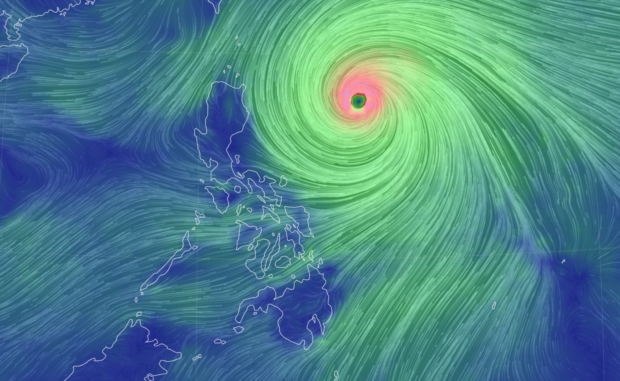
Betty was last spotted 715 kilometers east of Tuguegarao City, packing maximum sustained winds of 175 kilometers per hour (kph) with gustiness of up to 215 kph.
Based on Pagasa’s heavy rainfall outlook, the effects of Betty may begin on Monday (May 29) in the following areas:
- 100 to 200 millimeters (mm): The eastern portion of Babuyan Islands and the northeastern portion of mainland Cagayan.
- 50 to 100 mm: Batanes, the northwestern portion of mainland Cagayan, and the northern portions of Ilocos Norte and Apayao.
- Greater than 200 mm: Batanes, Babuyan Islands, and the northern portion of Ilocos Norte
- 100 to 200 mm: The northern portion of mainland Cagayan, the rest of Ilocos Norte, Ilocos Sur, La Union, Abra, and Benguet
- 50 to 100 mm: Pangasinan, Cordillera Administrative Region, and mainland Cagayan.
- Greater than 200 mm: Batanes, Ilocos Sur, the northern portion of La Union, and the northern part of Benguet
- 100 to 200 mm: Babuyan Islands, Ilocos Norte, Abra, and the rest of La Union and Benguet
- 50 to 100 mm: The northern portion of mainland Cagayan, Pangasinan, and the rest of Cordillera Administrative Region
READ: Typhoon Betty’s trough, southwesterly wind flow to bring rain in parts of PH
Pagasa likewise maintained its earlier forecast that Betty may enhance the southwest monsoon (locally termed habagat). This, it noted, may affect the western portions of Mimaropa and Western Visayas, as well as western parts of Calabarzon, Central, and Southern Luzon in the next few days.
READ: Pagasa warns of potential flash floods, landslides across PH