No heavy rains in NCR on Monday, monsoon may prevail on Wednesday — Pagasa
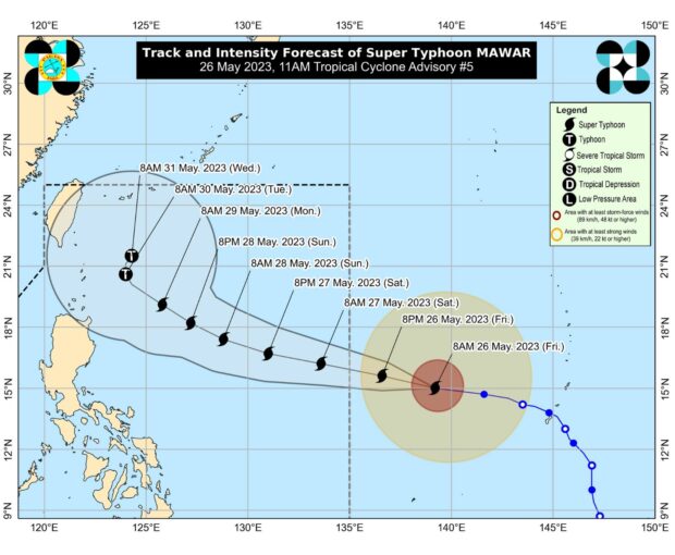
Track of Super Typhoon Mawar from Pagasa’s website
MANILA, Philippines — Despite Super Typhoon Mawar entering the Philippine area of responsibility (PAR) between Friday night and Saturday morning, state meteorologists forecast a likelihood that Metro Manila will not see much rain on Monday, May 29, 2023.
This is according to Philippine Atmospheric, Geophysical and Astronomical Services Administration (Pagasa) officer-in-charge Dr. Esperanza Cayanan.
Cayanan said numerical models show there won’t be much rain in the National Capital Region (NCR) beginning next week.
However, she clarified these are only models and must not be taken as absolute predictions.
Cayanan said the situation depends on Mawar’s track.
Article continues after this advertisementShe said the cyclone can be in a position where it will influence the southwest monsoon or ‘habagat.’
Article continues after this advertisement“So by Monday nakikita d’yan na wala masyadong ulan sa Metro Manila. Pero this is a model na ‘wag nating tutukan na kapag sinabing walang nakita, wala na, kasi we are experiencing thunderstorms every afternoon, and kung ‘yong bagyo natin ay tatahak do’n sa northeast — meron kasi kaming binabantayan na position na pwedeng mag-enhance talaga ng habagat,” she said.
(So by Monday, we see that there would be not much rain in Metro Manila, but this is only a model that we shouldn’t take as the only basis — that if we say there are no rains, there would be no rains. It’s because we are experiencing thunderstorms every afternoon, and if the cyclone moves northeast — we are monitoring a position where it can enhance the southwest monsoon.)
“So, by Tuesday, makikita natin na meron nang kaunting pag-ulan dito sa Metro Manila […] Pero ‘wag pa rin nating sabihin na totally wala tayong inaasahan ng Monday or Tuesday kasi may habagat na actually tayo by this time and ‘yong numerical models are just an estimation,” she added.
(So, by Tuesday, we can see that some areas in Metro Manila will have rains […] But let’s not say that there would be no rains totally for Monday or Tuesday because the southwest monsoon is already present by that time, and these numerical models are just estimations.)
Cayanan said the chances of rain are higher by Wednesday, as Mawar — which would be named “Betty” once it enters PAR — would be in a position where it could pull the southwesterly wind flow towards Metro Manila.
“Yong worst na scenario na nakikita na malakas na pag-ulan over Metro Manila is Wednesday, so kung saan medyo nasa far northeast na ‘yong bagyo at hahatak na ito ng habagat,” she explained.
(The worst case scenario that we saw is that the strong rains over Metro Manila would start by Wednesday, so that is when the cyclone has moved to the far northeast and can pull the southwest monsoon.)
“‘Yong ibang western provinces — ‘yong Mindoro kung titignan natin, siya ‘yong nakikita natin na mas malakas ‘yong pag-ulan, and of course, ‘yong western section ng Northern Luzon. And lagi kasi tayong nakatutok sa bagyo, so ‘yong Visayas and Mindanao, ‘yong western sections din natin ay nakikita natin na makakaranas ng pag-ulan,” she added.
(Other western provinces — like Mindoro, if we would take a look at it, we can see strong rains, and of course, the western section of Northern Luzon. And because we are monitoring the cyclone, we know that for Visayas and Mindanao, the western sections will also experience rains.)
Pagasa’s bulletin earlier said, as of Friday afternoon (May 26, 2023), Mawar was still packing maximum sustained winds of 215 kilometers per hour (kph) near the center and gustiness of up to 260 kph.
It was last seen 1,705 kilometers east of southeastern Luzon, moving west at the speed of 20 kph.
Pagasa meteorologists have also urged Filipinos not to be complacent, just because Mawar is expected to weaken once it enters PAR, as it would still be a typhoon-category cyclone.
Cayanan said in the same briefing that Mawar would not hit the country like Super Typhoon Yolanda did.
However, she urged the public not to think of it as weak, as it can still carry strong gusts of winds.
RELATED STORIES:
Super Typhoon Mawar even stronger as it gets nearer to PAR border
Super Typhoon Mawar even stronger as it roars closer to PAR border