Bongbong Marcos: LGUs to take lead on Mawar response; nat’l gov’t to assist
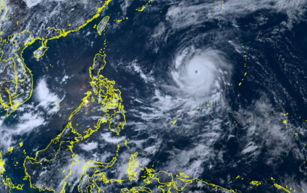
Track of Super Typhoon Mawar | PHOTO: Screengrab from Himawari 8 weather satellite
MANILA, Philippines — President Ferdinand Marcos Jr. on Friday said local government units (LGUs) should lead in responding to Super Typhoon Mawar and assured them that the national government would be ready to assist.
According to the state weather bureau, Mawar is anticipated to spawn heavy rain over several parts of the country. It will also enhance the southwest monsoon (locally known as habagat). The super typhoon will be named “Betty” once it enters the Philippine area of responsibility.
“We have already warned the LGUs to prepare in case of heavy rains and flooding. Ang aming ginagawa ay (What we do is) we leave it to the LGUs right now to make the call kung ano ‘yung gagawin nila (on what they will do),” Marcos said in an interview with reporters in Manila.
“Sinasabi namin (What we’re saying), the national government is here to assist. We are in constant contact with the local governments para makita natin (so we’ll see) what is the situation in their place,” he added.
After a storm, the President also said the national government would eventually find out the LGUs’ needs to respond appropriately to their respective situations.
Article continues after this advertisementAccording to Marcos, the government has been preparing for the onslaught of Mawar. It said it had a different strategy since the typhoon would also pull the southwest monsoon, which may cause heavy rain even in Visayas and Mindanao.
Article continues after this advertisement“It’s a little different from the usual situation kung saan dumadaan lang ang bagyo, ‘yun lang ang inaalala natin. Pero iba itong nangyari dito,” he said.
(It’s a little different from the usual situation where the typhoon passes. That’s all we worry about. But it happened differently here.)
“Malakas ang typhoon, eh. Humihila siya ng mga weather pattern, pumapasok dito sa Pilipinas. So that’s what we are looking out for,” he added.
(The typhoon is strong. It’s pulling weather patterns, entering here in the Philippines. So that’s what we are looking out for.)
Marcos said he had discussed with the Defense officer-in-charge Carlito Galvez the prepositioning of funds, food packs, and response teams.
READ: Palace: Gov’t monitoring Super Typhoon Mawar, contingency measures in place
In its latest update, the Philippine Atmospheric, Geophysical and Astronomical Services Administration said Mawar slightly intensified as it gets nearer the PAR border on Friday noon.
It also said that Mawar was last seen 1,705 kilometers east of southeastern Luzon, moving west at the speed of 20 kilometers per hour (kph) and packing maximum sustained winds of 215 kph near the center and gustiness of up to 260 kph. It
Mawar is anticipated to enter the PAR between Friday night and Saturday morning (May 27).