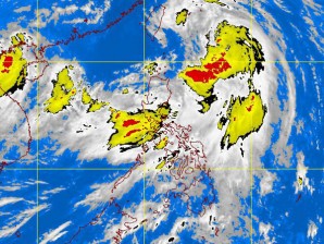
MANILA, Philippines — Tropical storm “Falcon” (international name: Maeri) has intensified further as it continues to move across Philippine waters, the Philippine Atmospheric, Geophysical and Astronomical Services Administration said Friday.
In its latest weather bulletin, Pagasa said that 370 km east northeast of Tuguegarao City and is now packing maximum sustained winds of 85 kph nea the center and gusts of up to 100kph.
Falcon is forecast to move 19 kph north northwest at 19 kph.
Signal number 1 remains raised over the Calayan, Babuyan and Batanes groups of islands, Pagasa said. All signal warnings have been lowered elsewhere.
“Residents in low lying and mountainous areas under signal number 1 are alerted against possible flashfloods and landslides,” Pagasa said.
Falcon is forecast to enhance the southwest monsoon and bring rains over Central and Southern Luzon, Visayas and Mindanao.
By Saturday morning, Falcon is expected to be 330 km northeast of Basco, Batanes and at 690 km north notheast of Basco, Batanes or 270 km west nothwest of Okinawa, Japan by Sunday morning.


