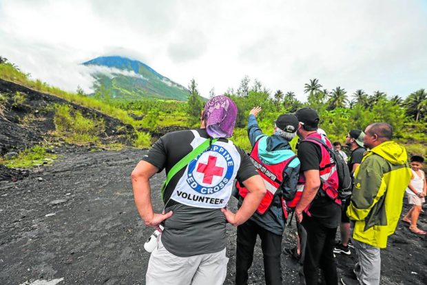
WHERE ARE THEY? | A low pressure area affecting most of Luzon hampers the search for the pilot, mechanic, and two Australian passengers of the Cessna plane that crashed on Saturday, Feb. 18, 2023, in Albay province. Rescuers paused to survey the area surrounding Mayon Volcano where scattered parts of the plane were found. (Photo by MARK ALVIC ESPLANA)
LEGAZPI CITY, Albay, Philippines — Disaster response officials, who were conducting search and rescue operations for the missing four people on board a Cessna plane, have tapped the local mountaineers to reach the crash site along the gullies of Mayon Volcano.
The debris of the Cessna RPC340 was located through an aerial inspection some 350 meters from the volcano’s crater on Sunday afternoon along the side of Camalig town in Albay province, a day after the aircraft went missing just minutes after taking off from Bicol International Airport (BIA) in Daraga, the town that adjoins this city where BIA was opened in 2021.
Still missing were Capt. Rufino James Crisostomo Jr., the pilot; his mechanic, Joel Martin; and their two Australian passengers, Simon Chipperfield and Karthi Santhanam, both consultants of the Energy Development Corp. (EDC).
The aircraft took off around 6:43 a.m. from BIA on Feb. 18 and was heading back to Manila after the two Australian passengers visited the EDC-operated BacMan Geothermal Power Plant, also in Albay, for inspection.
At a press briefing on Sunday, Eduardo Jimenez, EDC community relations officer, said they were hoping that the plane’s occupants would be found alive.
Camalig Mayor Carlos Irwin Baldo Jr., the incident commander, said by phone on Monday that they were still considering the weather and the recommendation of the Philippine Institute of Volcanology and Seismology (Phivolcs) as a sudden phreatic eruption posed a threat to the search and rescue teams.
“It would be risky to climb because of the continuous rains at the upper and lower portions of the volcano that could trigger movement of sand and boulders,” he said.
Extensive planning
Baldo said they tapped mountaineers, trained personnel from the Bureau of Fire Protection, and other experts to climb and reach the crash site, but they still needed extensive planning.
As of Monday afternoon, around 25 volunteer mountaineers were told to stand by and wait for the go signal from the command post.
Paul Karson Alanis, resident volcanologist of the Mayon Volcano Observatory Station at Ligñon Hill in this city, said Phivolcs has no mandate to give clearance on climbing on the volcano, adding the authority belongs to concerned local governments.
“In case they decide to mount the search and rescue, what we can give is regular updates on the status of Mayon,” Alanis said in a message.
The volcano is still under alert level 2, which means there is a possibility of a phreatic or magmatic eruption. Phivolcs had recorded 20 volcanic earthquakes and 21 rockfall events since alert level 2 was raised over Mayon on Oct. 7, 2022.
On Monday morning, 162 government rescuers were deployed to check on the gullies and river channels at the foot of the volcano and find the debris of the plane and possible signs of life.
Tim Lawrence Florece, Camalig’s information officer, said cloudy skies due to a low pressure area hampered the aerial inspection team of the Philippine Air Force Tactical Operations Group 5, which is based in this city, from penetrating the crash site at noon on Monday.
Risky climb
George Cordovilla, 51, leader of the local mountaineering group Albay Climbing Community, said they were familiar with the area where the tail and debris of the Cessna plane were found.
“If we start climbing at 8 a.m., we could reach the area at 4 p.m., but it depends on the terrain. We can’t move faster if it’s raining,” added Glen Calixto, 46, who heads Camp One Albay and one of the rescue responders in the 2013 eruption.
Cordovilla said they had passed through the crash site when they rescued a Russian mountaineer during the phreatic eruption in 2013. The easiest access to the area was the Miisi village in Daraga town, near the boundary of the adjacent town of Camalig, he added.
Cordovilla has reached the volcano’s summit more than 300 times and was one of the 27 local and foreign mountain climbers who were trekking when the volcano erupted on May 7, 2013. A Filipino tour guide and four German nationals were killed during the phreatic eruption.
“Mountaineers could really help a lot, especially because we know the area and the terrain. We are also equipped with gear, and we know how to survive in the area for an overnight stay or for two days,” Calixto told the Inquirer.
He said the initial trails followed by the team were dangerous, especially during rainy days, but mountaineers could follow different trail paths to easily reach the crash site.
They prepared tools they could use in clearing some bushes and debris that had possibly covered the trails through years of inactivity in the area.
After the 2013 eruption, the provincial government banned the conduct of trekking and mountaineering activities, including crater climbing, on the volcano.